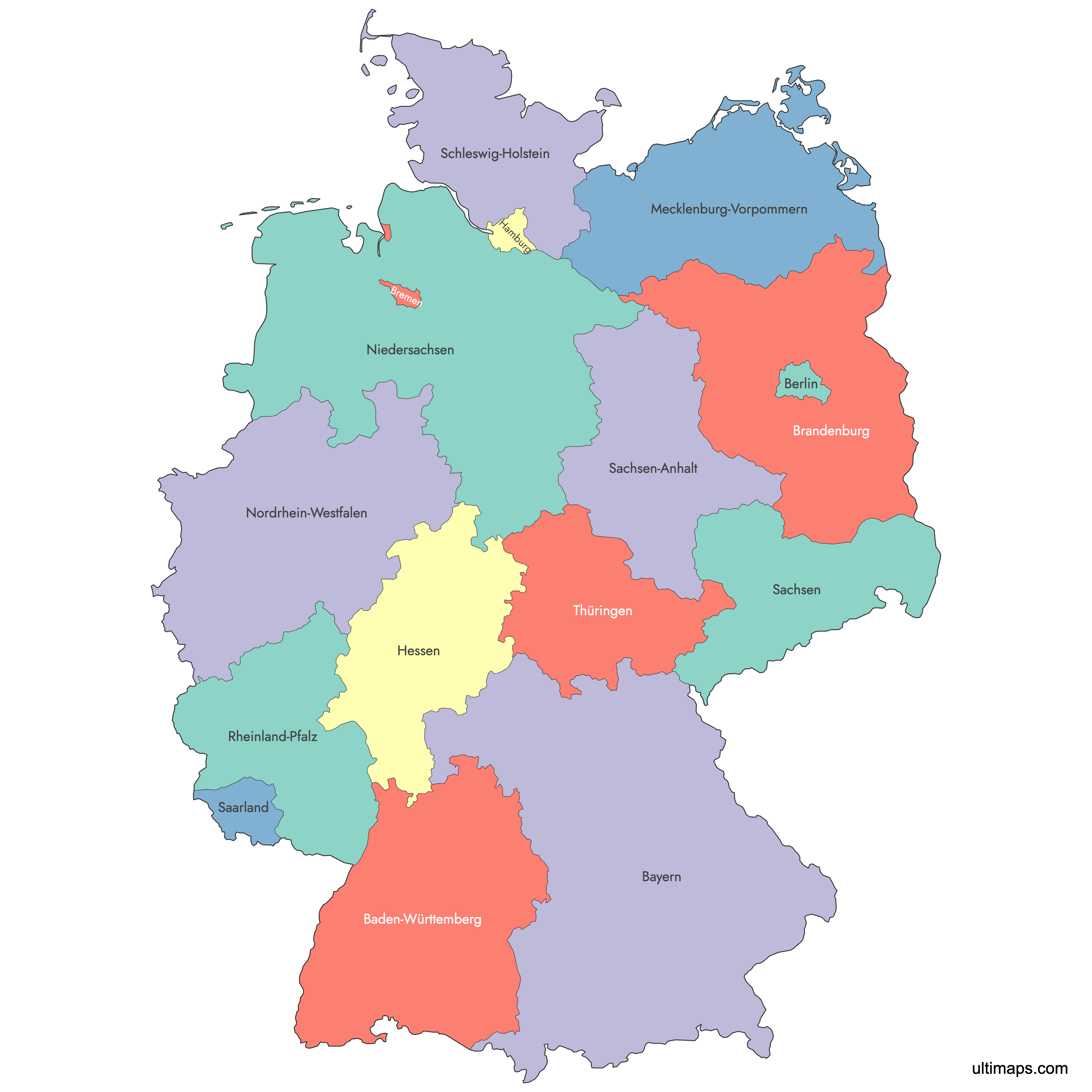
Map of Germany States
Germany is divided into 16 states (Bundesländer), including 13 area states and 3 city-states, each with its own constitution and government. Use the interactive maps below to explore state boundaries, capitals, and geographic features. Download free reference maps or learn more about creating a custom map of Germany to visualize your own data.
Interactive Map of Germany States
List of States (16)
| # | State |
|---|---|
| 1 | |
| 2 | |
| 3 | |
| 4 | |
| 5 | |
| 6 | |
| 7 | |
| 8 | |
| 9 | |
| 10 | |
| 11 | |
| 12 | |
| 13 | |
| 14 | |
| 15 | |
| 16 |
About Germany's States
- Number of States: 16 states (Bundesländer), comprising 13 area states and 3 city-states (Berlin, Hamburg, and Bremen).
- Capital: Berlin, which is also a city-state with approximately 3,755,000 residents (2022 estimate).
- Largest State by Area: Bavaria at 70,550 km² (27,239 sq mi).
- Smallest State by Area: Bremen at 419 km² (162 sq mi).
- Most Populous State: North Rhine-Westphalia with approximately 17,924,000 residents (2022 estimate).
- Least Populous State: Bremen with approximately 680,000 residents (2022 estimate).
- Total Population: Approximately 84.4 million (2022 estimate).
- Total Area: 357,022 km² (137,847 sq mi).
- Bordering Countries: Germany borders Denmark to the north, Poland and the Czech Republic to the east, Austria and Switzerland to the south, and France, Luxembourg, Belgium, and the Netherlands to the west. It also has coastlines on the North Sea and the Baltic Sea.
- Time Zone: Central European Time (CET, UTC+1), Central European Summer Time (CEST, UTC+2) during daylight saving.
- Current Boundaries Established: The 16-state structure was finalized on 3 October 1990 with German reunification, when five reconstituted eastern states and reunified Berlin joined the Federal Republic.
Interesting Facts
- North Rhine-Westphalia is home to roughly 17.9 million people, making it more populous than the Netherlands, its neighbor to the west.
- Bavaria alone is larger than the entire Republic of Ireland (70,273 km²) and accounts for nearly 20% of Germany's total land area.
- Bremen is both the smallest state by area and by population, yet it consists of two non-contiguous cities, Bremen and Bremerhaven, separated by about 60 km of Lower Saxony.
- The Zugspitze, Germany's highest peak at 2,962 meters (9,718 feet), sits in Bavaria on the border with Austria.
Free Downloads
You can download free blank Map of Germany States and other maps in high resolution PNG, SVG and PDF formats from the blank maps section of the site: Download Blank Map of Germany States
Custom Map Features
This map supports labels.
This map is divided into 16 states.
Updates
Sep 12, 2024:
- Added labels
Sep 28, 2023:
- Added map of Germany States
Frequently Asked Questions
Germany has 16 states, known as Bundesländer. Thirteen of these are area states, while three, Berlin, Hamburg, and Bremen, are city-states that function simultaneously as municipalities and federal states. This structure was established with German reunification on 3 October 1990.
Bavaria (Bayern) is the largest state by area at 70,550 km² (27,239 sq mi). It covers nearly one-fifth of Germany's total land area and is located in the southeast of the country. Its capital is Munich.
Bremen is the smallest state at just 419 km² (162 sq mi). It is a city-state made up of two non-contiguous cities: Bremen and Bremerhaven. Despite its small size, it has been an important trading port since the Middle Ages.
North Rhine-Westphalia is the most populous state with approximately 17.9 million residents as of 2022. Its capital is Düsseldorf, but its largest city is Cologne (Köln), with over 1 million inhabitants. The state also includes major cities such as Dortmund, Essen, and Duisburg.
The Brandenburg Gate and Museum Island are in Berlin. Neuschwanstein Castle is located in Bavaria near Füssen. The Cologne Cathedral, a UNESCO World Heritage Site, stands in North Rhine-Westphalia. Hamburg, a city-state in the north, is home to one of Europe's largest ports.
Germany shares borders with nine countries: Denmark to the north; Poland and the Czech Republic to the east; Austria and Switzerland to the south; and France, Luxembourg, Belgium, and the Netherlands to the west. It also has coastlines along the North Sea and the Baltic Sea.
You can use Ultimaps to create custom maps of Germany. Color-code states manually or upload your data, place pins, customize the look, and export to PNG, PDF, or SVG. No sign-up required.