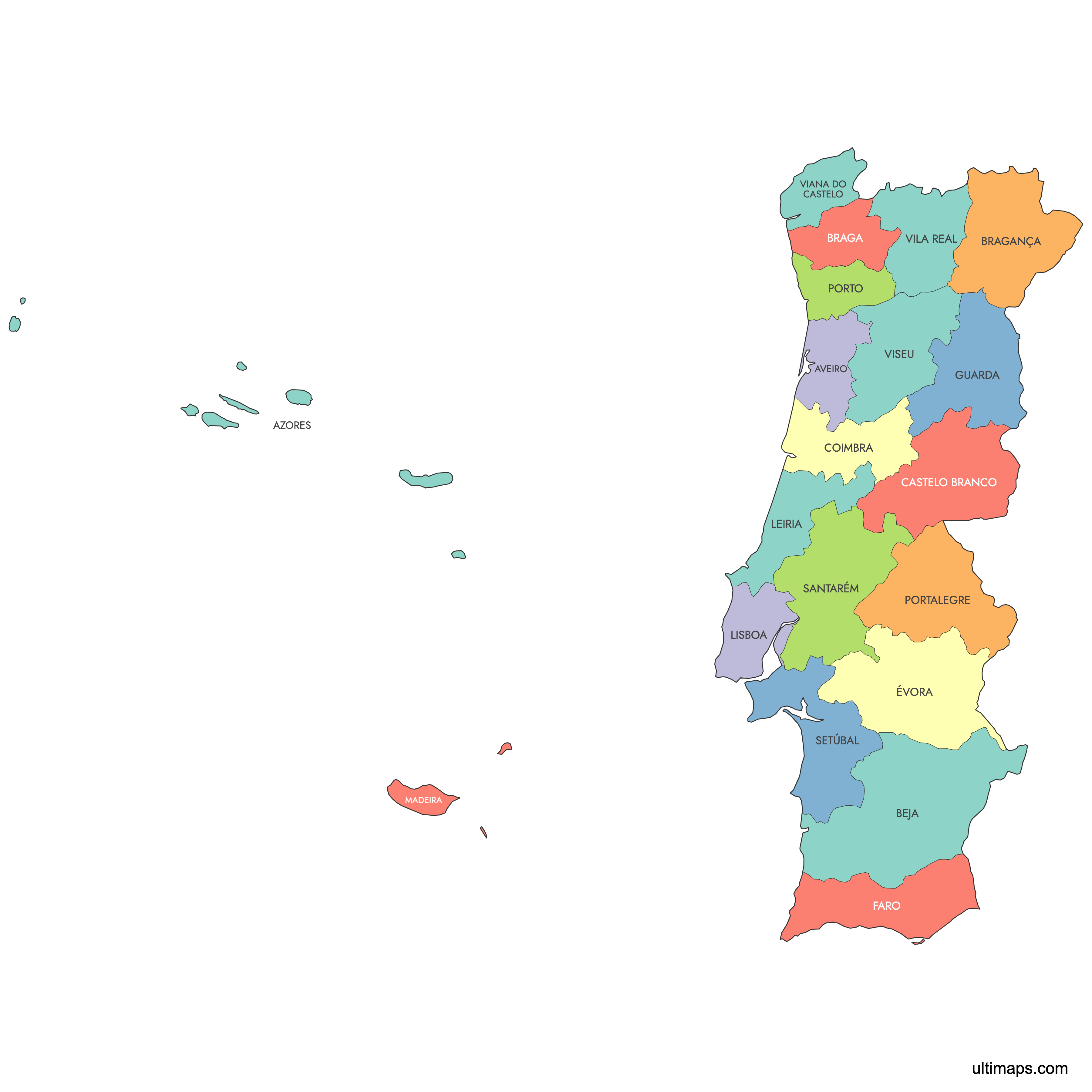
Map of Portugal Districts
Portugal's mainland is divided into 18 districts, the country's most historically significant geographic subdivisions. Use the interactive map below to explore district boundaries, capitals, and key cities. Download free reference maps or create a custom map of Portugal to visualize your own data.
Interactive Map of Portugal Districts
List of Districts (20)
| # | District |
|---|---|
| 1 | |
| 2 | |
| 3 | |
| 4 | |
| 5 | |
| 6 | |
| 7 | |
| 8 | |
| 9 | |
| 10 | |
| 11 | |
| 12 | |
| 13 | |
| 14 | |
| 15 | |
| 16 | |
| 17 | |
| 18 | |
| 19 | |
| 20 |
About Portugal's Districts
- Number of districts: 18 mainland districts (the Azores and Madeira are autonomous regions, not districts).
- Most populous district: Lisboa (Lisbon), with 2,250,533 residents (2011 census).
- Least populous district: Portalegre, with 118,506 residents (2011 census).
- Largest district by area: Beja, at 10,266 km² (3,964 sq mi).
- Smallest district by area: Viana do Castelo, at 2,219 km² (857 sq mi).
- Capital: Lisbon, located in the Lisboa district.
- Bordering countries: Spain to the north and east.
- Bordering bodies of water: Atlantic Ocean along the west and southwest coast.
- Time zone: Western European Time (WET, UTC+0), with Western European Summer Time (WEST, UTC+1) during daylight saving.
- Boundaries established: Districts were created by royal decree on 18 July 1835. Setúbal was the last district added, split from Lisboa in 1926.
Interesting Facts
- Interior districts cover roughly 63.8% of Portugal's mainland area but are home to fewer than two million people, which is less than the single district of Lisboa alone. This highlights the sharp coastal vs. interior population imbalance.
- Beja, the largest district, is about 4.6 times the size of Viana do Castelo, the smallest.
- Although the formal powers of district civil governors were removed in 2011, districts still serve as the basis for electoral constituencies, football associations, and police regions across mainland Portugal.
- Beneath the 18 districts, mainland Portugal contains 308 municipalities (concelhos) and 3,259 civil parishes (freguesias) as of 2025.
- The 1976 Portuguese Constitution defined districts as transitional, intended to be replaced by administrative regions, but those regions were never fully implemented, so districts persist in everyday use.
Free Downloads
You can download free blank Map of Portugal Districts and other maps in high resolution PNG, SVG and PDF formats from the blank maps section of the site: Download Blank Map of Portugal Districts
Custom Map Features
This map supports labels.
This map is divided into 20 districts.
Updates
Sep 28, 2023:
- Added map of Portugal Districts
Frequently Asked Questions
Portugal's mainland is divided into 18 districts: Aveiro, Beja, Braga, Bragança, Castelo Branco, Coimbra, Évora, Faro, Guarda, Leiria, Lisboa, Portalegre, Porto, Santarém, Setúbal, Viana do Castelo, Vila Real, and Viseu. The Azores and Madeira are classified as autonomous regions, not districts. Districts were established by royal decree on 18 July 1835, with Setúbal added in 1926.
Beja is the largest district, covering 10,266 km² (3,964 sq mi) in the southern Alentejo region. It is roughly 4.6 times larger than the smallest district, Viana do Castelo. Despite its size, Beja is one of the least densely populated districts on the mainland.
Viana do Castelo is the smallest district, with an area of 2,219 km² (857 sq mi). It sits in the far northwest of mainland Portugal along the Atlantic coast. The district is known for its coastal city and the Sanctuary of Santa Luzia.
Lisboa (Lisbon) is the most populous district, with 2,250,533 residents recorded in the 2011 census. It covers 2,801 km² (1,082 sq mi) and contains the national capital. The least populous district is Portalegre, with just 118,506 residents in the same census.
Porto, Portugal's second-largest city and a major port wine hub, is in the Porto district. Évora, a UNESCO World Heritage city with a Roman temple and the Capela dos Ossos, is the capital of the Évora district. Coimbra, home to one of Europe's oldest universities, is in the Coimbra district, while the Algarve beach towns of Lagos, Albufeira, and Portimão fall within the Faro district.
Portugal shares its only land border with Spain to the north and east. Eight districts touch the Spanish border, including Viana do Castelo, Bragança, Guarda, Castelo Branco, Portalegre, Évora, Beja, and Faro. The Atlantic Ocean borders Portugal along its entire west and southwest coast, with ten districts having a coastline.
You can use Ultimaps to create custom maps of Portugal. Color-code districts manually or upload your data, place pins, customize the look, and export to PNG, PDF, or SVG. No sign-up required.