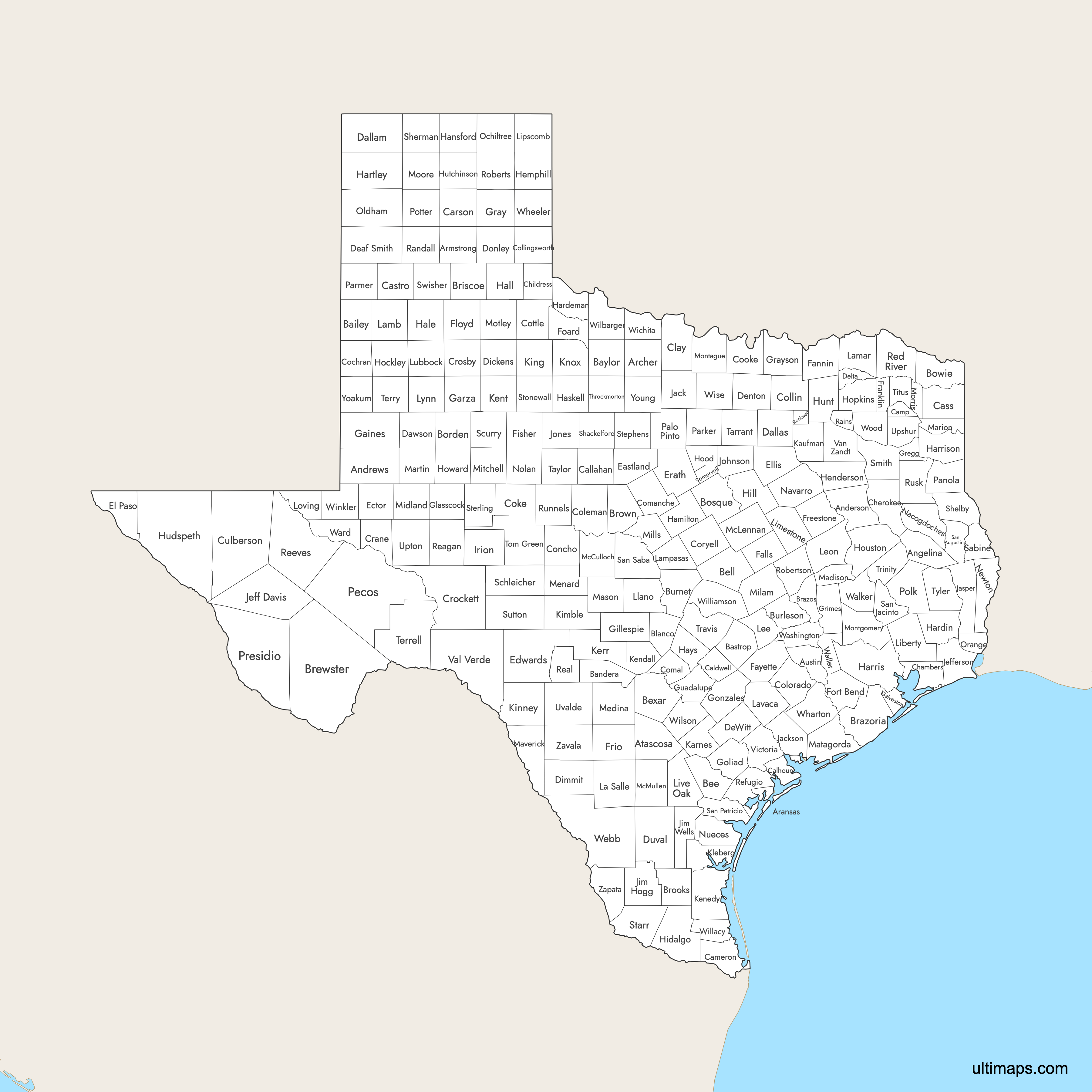
Map of Texas Counties
Texas is divided into 254 counties, the highest number of any US state. Use the interactive maps below to explore counties and their boundaries. Download free maps or learn more about creating a custom Texas county map to highlight your own data.
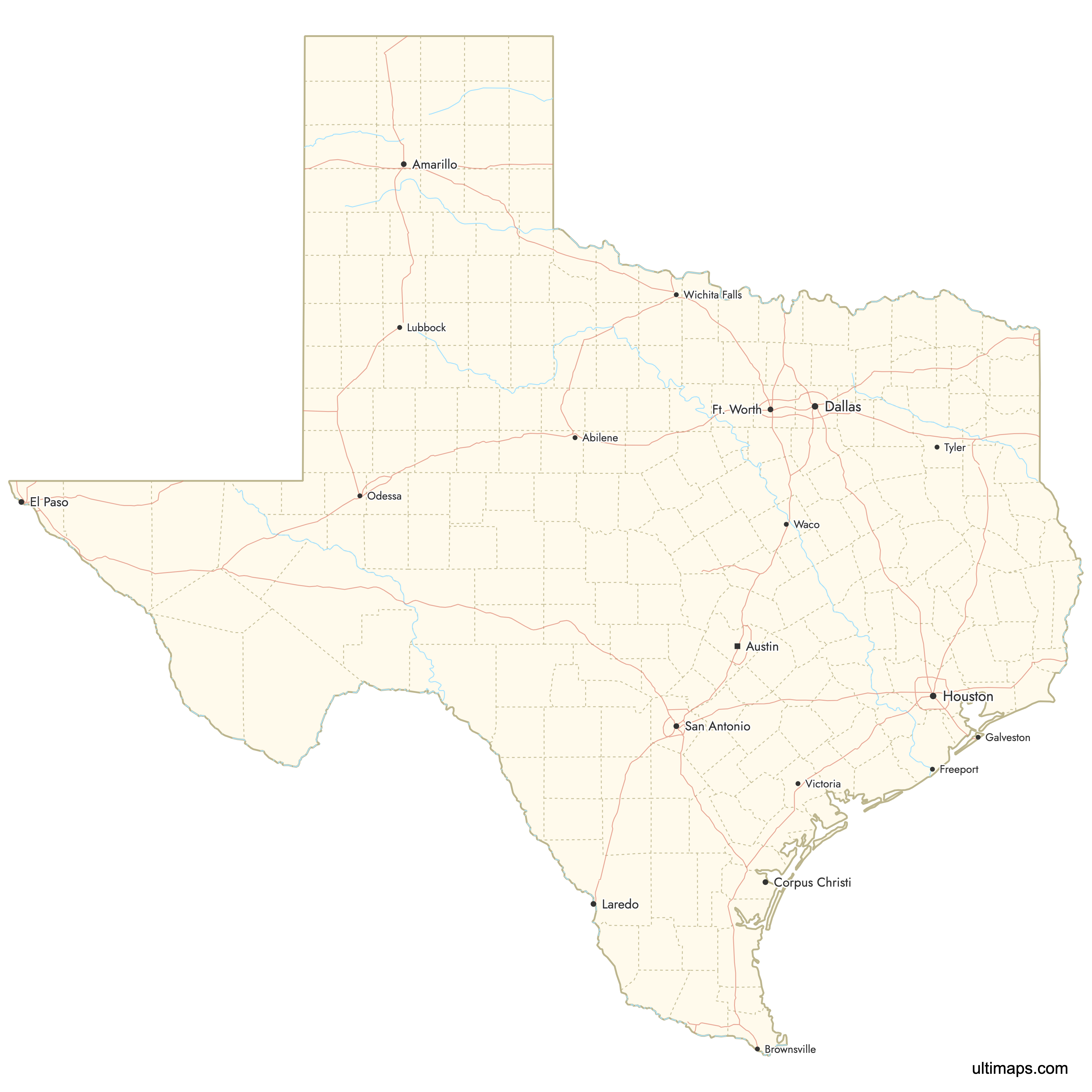
Interactive Map of Texas Counties
List of Counties (254)
| # | County | County seat | Year founded |
|---|---|---|---|
| 1 | Palestine | 1846 | |
| 2 | Andrews | 1876 | |
| 3 | Lufkin | 1846 | |
| 4 | Rockport | 1871 | |
| 5 | Archer City | 1858 | |
| 6 | Claude | 1876 | |
| 7 | Jourdanton | 1856 | |
| 8 | Bellville | 1836 | |
| 9 | Muleshoe | 1876 | |
| 10 | Bandera | 1856 | |
| 11 | Bastrop | 1836 | |
| 12 | Seymour | 1858 | |
| 13 | Beeville | 1857 | |
| 14 | Belton | 1850 | |
| 15 | San Antonio | 1836 | |
| 16 | Johnson City | 1858 | |
| 17 | Gail | 1876 | |
| 18 | Meridian | 1854 | |
| 19 | Boston | 1840 | |
| 20 | Angleton | 1836 | |
| 21 | Bryan | 1841 | |
| 22 | Alpine | 1887 | |
| 23 | Silverton | 1876 | |
| 24 | Falfurrias | 1911 | |
| 25 | Brownwood | 1856 | |
| 26 | Caldwell | 1846 | |
| 27 | Burnet | 1852 | |
| 28 | Lockhart | 1848 | |
| 29 | Port Lavaca | 1846 | |
| 30 | Baird | 1858 | |
| 31 | Brownsville | 1848 | |
| 32 | Pittsburg | 1874 | |
| 33 | Panhandle | 1876 | |
| 34 | Linden | 1846 | |
| 35 | Dimmitt | 1876 | |
| 36 | Anahuac | 1858 | |
| 37 | Rusk | 1846 | |
| 38 | Childress | 1876 | |
| 39 | Henrietta | 1857 | |
| 40 | Morton | 1876 | |
| 41 | Robert Lee | 1889 | |
| 42 | Coleman | 1858 | |
| 43 | McKinney | 1846 | |
| 44 | Wellington | 1876 | |
| 45 | Columbus | 1836 | |
| 46 | New Braunfels | 1846 | |
| 47 | Comanche | 1856 | |
| 48 | Paint Rock | 1858 | |
| 49 | Gainesville | 1848 | |
| 50 | Gatesville | 1854 | |
| 51 | Paducah | 1876 | |
| 52 | Crane | 1887 | |
| 53 | Ozona | 1875 | |
| 54 | Crosbyton | 1876 | |
| 55 | Van Horn | 1911 | |
| 56 | Dalhart | 1876 | |
| 57 | Dallas | 1846 | |
| 58 | Lamesa | 1876 | |
| 59 | Hereford | 1876 | |
| 60 | Cooper | 1870 | |
| 61 | Denton | 1846 | |
| 62 | Cuero | 1846 | |
| 63 | Dickens | 1876 | |
| 64 | Carrizo Springs | 1858 | |
| 65 | Clarendon | 1876 | |
| 66 | San Diego | 1858 | |
| 67 | Eastland | 1858 | |
| 68 | Odessa | 1887 | |
| 69 | Rocksprings | 1858 | |
| 70 | El Paso | 1848 | |
| 71 | Waxahachie | 1849 | |
| 72 | Stephenville | 1856 | |
| 73 | Marlin | 1850 | |
| 74 | Bonham | 1837 | |
| 75 | La Grange | 1837 | |
| 76 | Roby | 1876 | |
| 77 | Floydada | 1876 | |
| 78 | Crowell | 1891 | |
| 79 | Richmond | 1837 | |
| 80 | Mount Vernon | 1875 | |
| 81 | Fairfield | 1850 | |
| 82 | Pearsall | 1858 | |
| 83 | Seminole | 1876 | |
| 84 | Galveston | 1838 | |
| 85 | Post | 1876 | |
| 86 | Fredericksburg | 1848 | |
| 87 | Garden City | 1887 | |
| 88 | Goliad | 1836 | |
| 89 | Gonzales | 1836 | |
| 90 | Pampa | 1876 | |
| 91 | Sherman | 1846 | |
| 92 | Longview | 1873 | |
| 93 | Anderson | 1846 | |
| 94 | Seguin | 1846 | |
| 95 | Plainview | 1876 | |
| 96 | Memphis | 1876 | |
| 97 | Hamilton | 1856 | |
| 98 | Spearman | 1876 | |
| 99 | Quanah | 1858 | |
| 100 | Kountze | 1858 | |
| 101 | Houston | 1836 | |
| 102 | Marshall | 1839 | |
| 103 | Channing | 1876 | |
| 104 | Haskell | 1858 | |
| 105 | San Marcos | 1848 | |
| 106 | Canadian | 1876 | |
| 107 | Athens | 1846 | |
| 108 | Edinburg | 1852 | |
| 109 | Hillsboro | 1853 | |
| 110 | Levelland | 1876 | |
| 111 | Granbury | 1866 | |
| 112 | Sulphur Springs | 1846 | |
| 113 | Crockett | 1837 | |
| 114 | Big Spring | 1876 | |
| 115 | Sierra Blanca | 1917 | |
| 116 | Greenville | 1846 | |
| 117 | Stinnett | 1876 | |
| 118 | Mertzon | 1889 | |
| 119 | Jacksboro | 1856 | |
| 120 | Edna | 1836 | |
| 121 | Jasper | 1836 | |
| 122 | Fort Davis | 1887 | |
| 123 | Beaumont | 1836 | |
| 124 | Hebbronville | 1913 | |
| 125 | Alice | — | |
| 126 | Cleburne | — | |
| 127 | Anson | — | |
| 128 | Karnes City | — | |
| 129 | Kaufman | — | |
| 130 | Boerne | — | |
| 131 | Sarita | — | |
| 132 | Jayton | — | |
| 133 | Kerrville | — | |
| 134 | Junction | — | |
| 135 | Guthrie | — | |
| 136 | Brackettville | — | |
| 137 | Kingsville | — | |
| 138 | Benjamin | — | |
| 139 | Cotulla | — | |
| 140 | Paris | — | |
| 141 | Littlefield | — | |
| 142 | Lampasas | — | |
| 143 | Hallettsville | — | |
| 144 | Giddings | — | |
| 145 | Centerville | — | |
| 146 | Liberty | — | |
| 147 | Groesbeck | — | |
| 148 | Booker | — | |
| 149 | George West | — | |
| 150 | Llano | — | |
| 151 | Mentone | — | |
| 152 | Lubbock | — | |
| 153 | Tahoka | — | |
| 154 | Madisonville | — | |
| 155 | Jefferson | — | |
| 156 | Stanton | — | |
| 157 | Mason | — | |
| 158 | Bay City | — | |
| 159 | Eagle Pass | — | |
| 160 | Brady | — | |
| 161 | Waco | — | |
| 162 | Tilden | — | |
| 163 | Hondo | — | |
| 164 | Menard | — | |
| 165 | Midland | — | |
| 166 | Cameron | — | |
| 167 | Goldthwaite | — | |
| 168 | Colorado City | — | |
| 169 | Montague | — | |
| 170 | Conroe | — | |
| 171 | Dumas | — | |
| 172 | Daingerfield | — | |
| 173 | Matador | — | |
| 174 | Nacogdoches | — | |
| 175 | Corsicana | — | |
| 176 | Newton | — | |
| 177 | Sweetwater | — | |
| 178 | Corpus Christi | — | |
| 179 | Perryton | — | |
| 180 | Vega | — | |
| 181 | Orange | — | |
| 182 | Palo Pinto | — | |
| 183 | Carthage | — | |
| 184 | Weatherford | — | |
| 185 | Farwell | — | |
| 186 | Fort Stockton | — | |
| 187 | Livingston | — | |
| 188 | Amarillo | — | |
| 189 | Marfa | — | |
| 190 | Emory | — | |
| 191 | Canyon | — | |
| 192 | Big Lake | — | |
| 193 | Leakey | — | |
| 194 | Clarksville | — | |
| 195 | Pecos | — | |
| 196 | Refugio | — | |
| 197 | Miami | — | |
| 198 | Franklin | — | |
| 199 | Rockwall | — | |
| 200 | Ballinger | — | |
| 201 | Henderson | — | |
| 202 | Hemphill | — | |
| 203 | San Augustine | — | |
| 204 | Coldspring | — | |
| 205 | Sinton | — | |
| 206 | San Saba | — | |
| 207 | Eldorado | — | |
| 208 | Snyder | — | |
| 209 | Albany | — | |
| 210 | Center | — | |
| 211 | Stratford | — | |
| 212 | Tyler | — | |
| 213 | Glen Rose | — | |
| 214 | Rio Grande City | — | |
| 215 | Breckenridge | — | |
| 216 | Sterling City | — | |
| 217 | Aspermont | — | |
| 218 | Sonora | — | |
| 219 | Tulia | — | |
| 220 | Fort Worth | — | |
| 221 | Abilene | — | |
| 222 | Sanderson | — | |
| 223 | Brownfield | — | |
| 224 | Throckmorton | — | |
| 225 | Mount Pleasant | — | |
| 226 | San Angelo | — | |
| 227 | Austin | — | |
| 228 | Groveton | — | |
| 229 | Woodville | — | |
| 230 | Gilmer | — | |
| 231 | Rankin | — | |
| 232 | Uvalde | — | |
| 233 | Del Rio | — | |
| 234 | Canton | — | |
| 235 | Victoria | — | |
| 236 | Huntsville | — | |
| 237 | Hempstead | — | |
| 238 | Monahans | — | |
| 239 | Brenham | — | |
| 240 | Laredo | — | |
| 241 | Wharton | — | |
| 242 | Wheeler | — | |
| 243 | Wichita Falls | — | |
| 244 | Vernon | — | |
| 245 | Raymondville | — | |
| 246 | Georgetown | — | |
| 247 | Floresville | — | |
| 248 | Kermit | — | |
| 249 | Decatur | — | |
| 250 | Quitman | — | |
| 251 | Plains | — | |
| 252 | Graham | — | |
| 253 | Zapata | — | |
| 254 | Crystal City | — |
Texas Counties: Key Facts
County boundaries in Texas date back to the 19th century, formed as the state expanded west and populations grew. Today, Texas counties vary in both size and population, from rural areas to densely populated urban centers.
- Number of counties: 254 (most of any state)
- Largest county by area: Brewster County - 6,192 square miles (16,041 km²)
- Most populous county: Harris County (Houston) - about 4.7 million residents
- Least populous county: Loving County (Mentone) - 64 people (2020 Census)
- Smallest county by area: Rockwall County - 149 square miles (386 km²)
- Counties with major urban centers: Dallas (Dallas), Harris (Houston), Tarrant (Fort Worth), Bexar (San Antonio), Travis (Austin), El Paso (El Paso)
- Time zones: Central Time for most counties; Mountain Time in El Paso and Hudspeth
- Neighboring states: New Mexico, Oklahoma, Arkansas, Louisiana
- International border: 1,254 mi (2,018 km) with Mexico along the Rio Grande
The first Texas counties were formed in 1836 after independence from Mexico. County boundaries largely unchanged since 1931 (re-creation of Loving County).
Free Downloads
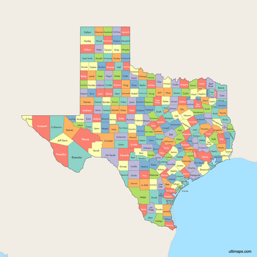 Colored Map of Texas Counties with Surrounding Areaspng1229 KB
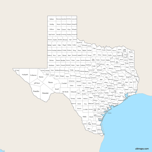 Labeled Map of Texas Counties with Surrounding Areaspng1166 KB
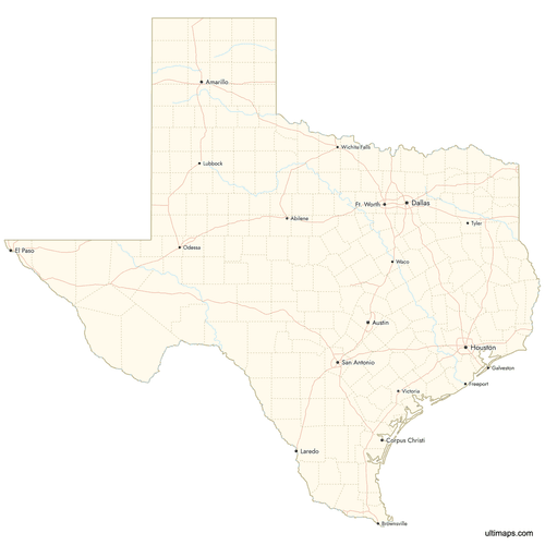 Map of Texas Counties with Citiespng1067 KB

You can download free blank Map of Texas Counties and other maps in high resolution PNG, SVG and PDF formats from the blank maps section of the site: Download Blank Map of Texas Counties
Custom Map Features
This map supports labels.
This map supports surrounding areas, roads, rivers and cities. New
This map is divided into 254 counties.
Updates
Jul 25, 2025:
- Improved map quality
- Added support for surrounding areas and lakes
Aug 26, 2024:
- Added map of Texas Counties


