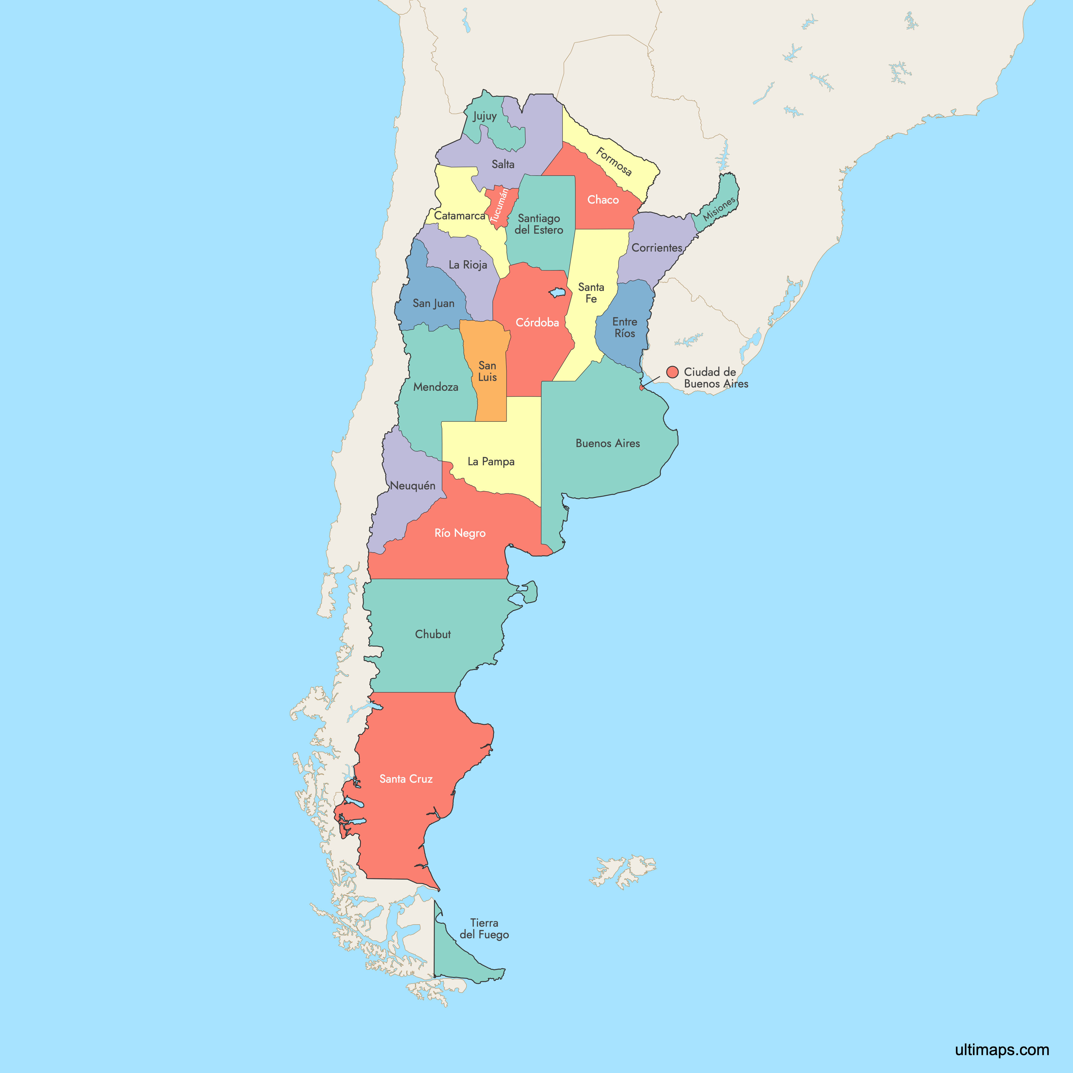
Map of Argentina Provinces
Argentina is divided into 23 provinces and the Autonomous City of Buenos Aires, the federal capital. Each province has its own capital and governance. Use the interactive maps below to explore the provinces and their boundaries. Download free maps or learn how to create a custom map of Argentina to visualize your own data.
Interactive Map of Argentina Provinces
List of Provinces (24)
| # | Province |
|---|---|
| 1 | |
| 2 | |
| 3 | |
| 4 | |
| 5 | |
| 6 | |
| 7 | |
| 8 | |
| 9 | |
| 10 | |
| 11 | |
| 12 | |
| 13 | |
| 14 | |
| 15 | |
| 16 | |
| 17 | |
| 18 | |
| 19 | |
| 20 | |
| 21 | |
| 22 | |
| 23 | |
| 24 |
Argentina Provinces: Key Facts
- Number of provinces: 23 provinces plus the Autonomous City of Buenos Aires.
- Largest province by area: Buenos Aires Province, covering approximately 118,754 square miles (307,571 km²).
- Most populous province: Buenos Aires Province, with over 17 million inhabitants as of 2022.
- Smallest province by area: Tucumán, with an area of about 8,764 square miles (22,524 km²).
- Least populous province: Tierra del Fuego, with a population of about 190,641 as of the 2022 census.
- Major urban centers: Buenos Aires (Autonomous City), Córdoba, Rosario (in Santa Fe), Mendoza, and La Plata.
- Neighboring countries: Chile, Bolivia, Paraguay, Brazil, and Uruguay.
- Time zone: Argentina Time Zone (ART), UTC-3.
- Provincial capitals: Each province has its own capital, such as La Plata, Córdoba, and Mendoza.
- Regions: Provinces are grouped into regions like the Pampas, Patagonia, Cuyo, Northwest, and Northeast.
- Interesting fact: Tierra del Fuego includes part of Antarctica and several South Atlantic islands claimed by Argentina.
Free Downloads
 Colored Map of Argentina Provinces with Surrounding Areaspng771 KB
 Labeled Map of Argentina Provinces with Surrounding Areaspng771 KB

You can download free blank Map of Argentina Provinces and other maps in high resolution PNG, SVG and PDF formats from the blank maps section of the site: Download Blank Map of Argentina Provinces
Custom Map Features
This map supports labels.
This map supports surrounding areas. New
This map is divided into 24 provinces.
Updates
Nov 25, 2025:
- Improved map quality
- Added support for surrounding areas and lakes
Sep 26, 2024:
- Added map of Argentina
Frequently Asked Questions
Argentina has 23 provinces and one autonomous city, Buenos Aires, which serves as the federal capital.
Buenos Aires Province is the largest, with an area of 307,571 km² (118,754 square miles).
Tucumán is the smallest province, with an area of 22,524 km² (8,764 square miles).
Buenos Aires Province is the most populous, with over 17 million inhabitants as of the 2022 census.
Tierra del Fuego is the least populous province, with about 190,641 residents as of 2022.
Argentina shares borders with Chile, Bolivia, Paraguay, Brazil, and Uruguay.
You can use Ultimaps to create custom maps of Argentina. Color-code provinces manually or upload data, place pins, customize look and feel, and export to PNG, PDF, or SVG.