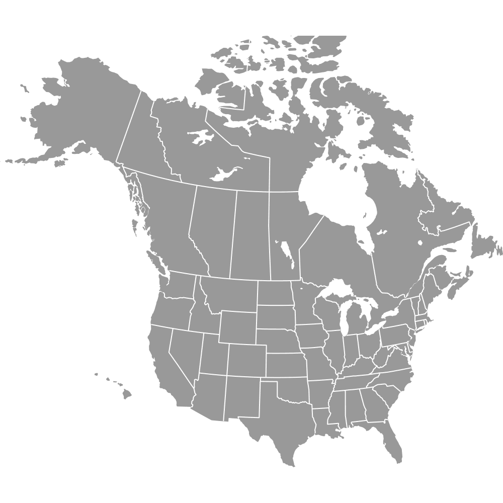
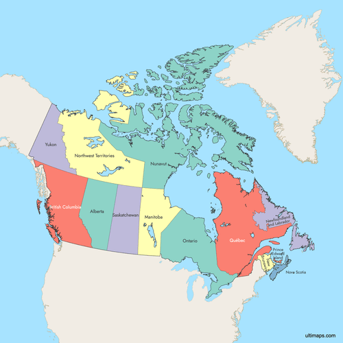
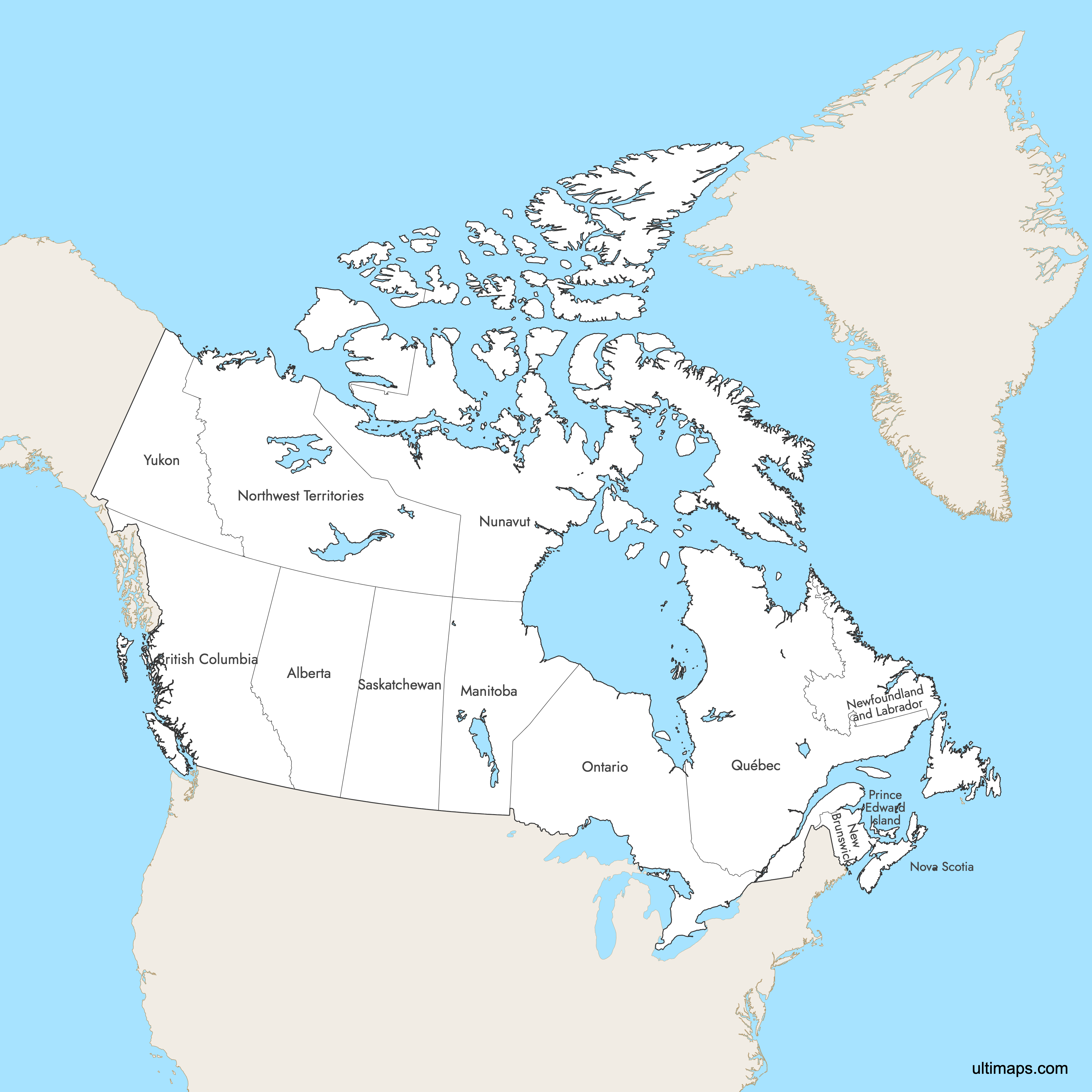
Map of Canada Provinces
Canada is divided into 10 provinces and 3 territories, spanning 3,855,100 square miles (9,984,670 km²) from the Atlantic to the Pacific and Arctic oceans. Each province functions as a distinct administrative region with its own capital and government, while the three northern territories cover over 40% of Canada's land area. Use the interactive maps below to explore provinces, territories, and their boundaries. Download free maps or learn more about creating a custom map of Canada to visualize your own data.
Interactive Map of Canada Provinces
List of Provinces (13)
| # | Province |
|---|---|
| 1 | |
| 2 | |
| 3 | |
| 4 | |
| 5 | |
| 6 | |
| 7 | |
| 8 | |
| 9 | |
| 10 | |
| 11 | |
| 12 | |
| 13 |
Canada Provinces: Key Facts
- Total number of provinces: 10 provinces plus 3 territories (13 first-level administrative divisions total)
- Most populous province: Ontario with 14,223,942 residents (2021 Census)
- Least populous territory: Nunavut with 36,858 residents (2021 Census)
- Largest region by area: Nunavut (territory) at approximately 808,185 square miles (2,093,190 km²)
- Smallest province by area: Prince Edward Island at approximately 2,184 square miles (5,660 km²)
- Major urban centers: Ontario (Toronto, Ottawa, Hamilton), Quebec (Montreal, Quebec City), British Columbia (Vancouver), Alberta (Calgary, Edmonton), Manitoba (Winnipeg)
- National capital: Ottawa, located in Ontario province
- Borders: United States to the south and northwest (world's longest binational land border), Atlantic Ocean (east), Pacific Ocean (west), Arctic Ocean (north)
- Time zones: Six primary zones from west to east: Pacific, Mountain, Central, Eastern, Atlantic, and Newfoundland
- Boundary establishment: Original four provinces (Ontario, Quebec, New Brunswick, Nova Scotia) formed July 1, 1867; most recent addition was Nunavut, created in 1999
Interesting Facts
- Canada ranks second globally by total area, behind only Russia.
- Newfoundland and Labrador was Canada's newest province, joining in 1949 after a referendum, making it the only province to join through popular vote.
- The three territories form "the North," covering over 40% of Canada's land but containing less than 1% of its population.
- Hudson Bay, one of the world's largest inland seas, borders Ontario, Quebec, Manitoba, and Nunavut.
- The Rocky Mountains run along the British Columbia-Alberta border, home to famous national parks like Banff.
Free Downloads
 Colored Map of Canada Provinces with Surrounding Areaspng1943 KB
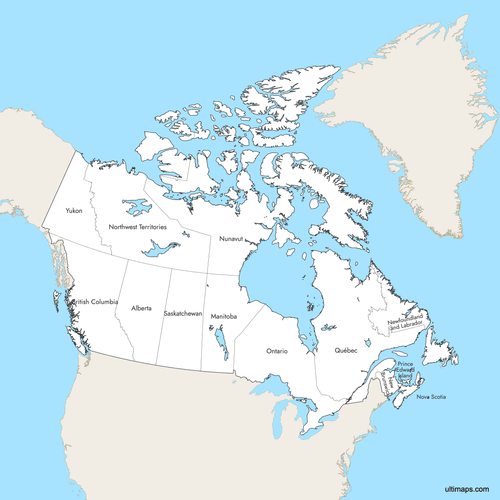 Labeled Map of Canada Provinces with Surrounding Areaspng1861 KB
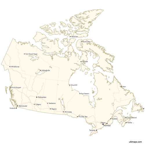 Map of Canada Provinces with Citiespng1391 KB


You can download free blank Map of Canada Provinces and other maps in high resolution PNG, SVG and PDF formats from the blank maps section of the site: Download Blank Map of Canada Provinces
Custom Map Features
This map supports labels.
This map supports surrounding areas, roads, rivers and cities. New
This map is divided into 13 provinces.
Updates
Jul 25, 2025:
- Improved map quality
- Added support for surrounding areas and lakes
Oct 2, 2024:
- Changed projection and added labels to the provinces
Apr 14, 2024:
- Added map of Canada Provinces
Frequently Asked Questions
Canada has 10 provinces and 3 territories, for a total of 13 first-level administrative divisions. The provinces are British Columbia, Alberta, Saskatchewan, Manitoba, Ontario, Quebec, New Brunswick, Nova Scotia, Prince Edward Island, and Newfoundland and Labrador. The three territories are Yukon, Northwest Territories, and Nunavut.
Nunavut is the largest region by area at approximately 808,185 square miles (2,093,190 km²). However, Nunavut is a territory, not a province. Among provinces only, Quebec is the largest by area. The three territories combined cover over 40% of Canada's total land area.
Prince Edward Island is the smallest province by area at approximately 2,184 square miles (5,660 km²). Despite its compact size, PEI is known for its red sand beaches and as the birthplace of Canadian Confederation.
Ontario is the most populous province with 14,223,942 residents according to the 2021 Census. Ontario is home to Toronto, Canada's largest city and economic hub, as well as Ottawa, the national capital. The province contains roughly 38% of Canada's total population.
Toronto, Canada's largest city, is located in Ontario. Montreal, the country's second-largest city and a major cultural center, is in Quebec. Vancouver, a major Pacific port city, is in British Columbia. Calgary and Edmonton, both significant economic centers, are in Alberta. Winnipeg, known as the gateway to the prairies, is in Manitoba.
Provinces have constitutional powers granted under the Constitution Act, while territories derive their powers from the federal government. The three territories (Yukon, Northwest Territories, and Nunavut) cover over 40% of Canada's land area but contain less than 1% of its population. Territories are located in the northern region of Canada.
The original four provinces (Ontario, Quebec, New Brunswick, Nova Scotia) formed on July 1, 1867. Manitoba joined in 1870, British Columbia in 1871, and Prince Edward Island in 1873. Newfoundland and Labrador was the last province to join, in 1949 after a referendum. Nunavut, the newest territory, was created in 1999.
Each province has its own capital: British Columbia (Victoria), Alberta (Edmonton), Saskatchewan (Regina), Manitoba (Winnipeg), Ontario (Toronto), Quebec (Quebec City), New Brunswick (Fredericton), Nova Scotia (Halifax), Prince Edward Island (Charlottetown), and Newfoundland and Labrador (St. John's). Ottawa, the national capital, is located in Ontario.
You can use Ultimaps to create custom maps of Canada. Color-code provinces manually or upload your data, place pins, customize the look and feel, and export to PNG, PDF, or SVG. No sign-up required.