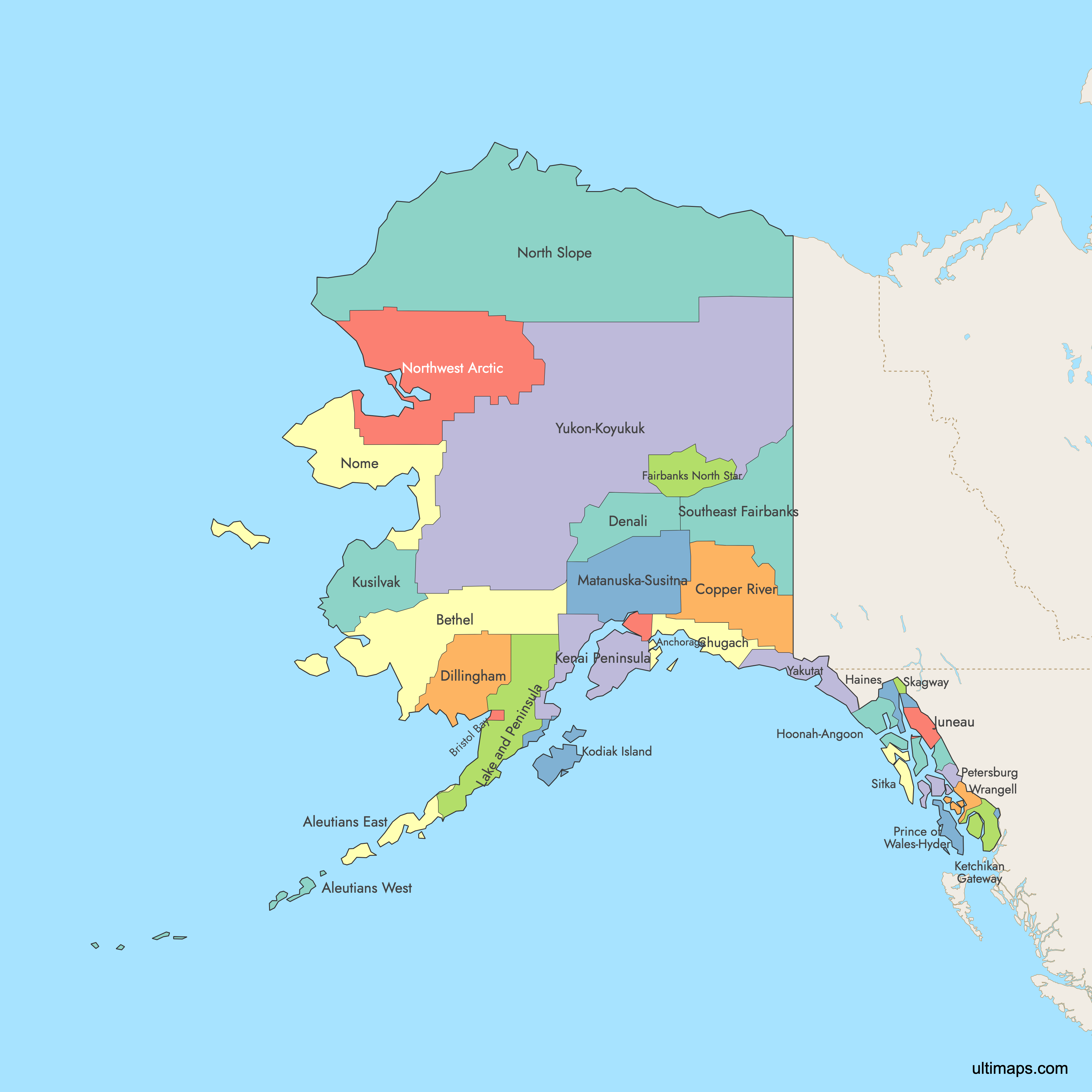
Map of Alaska
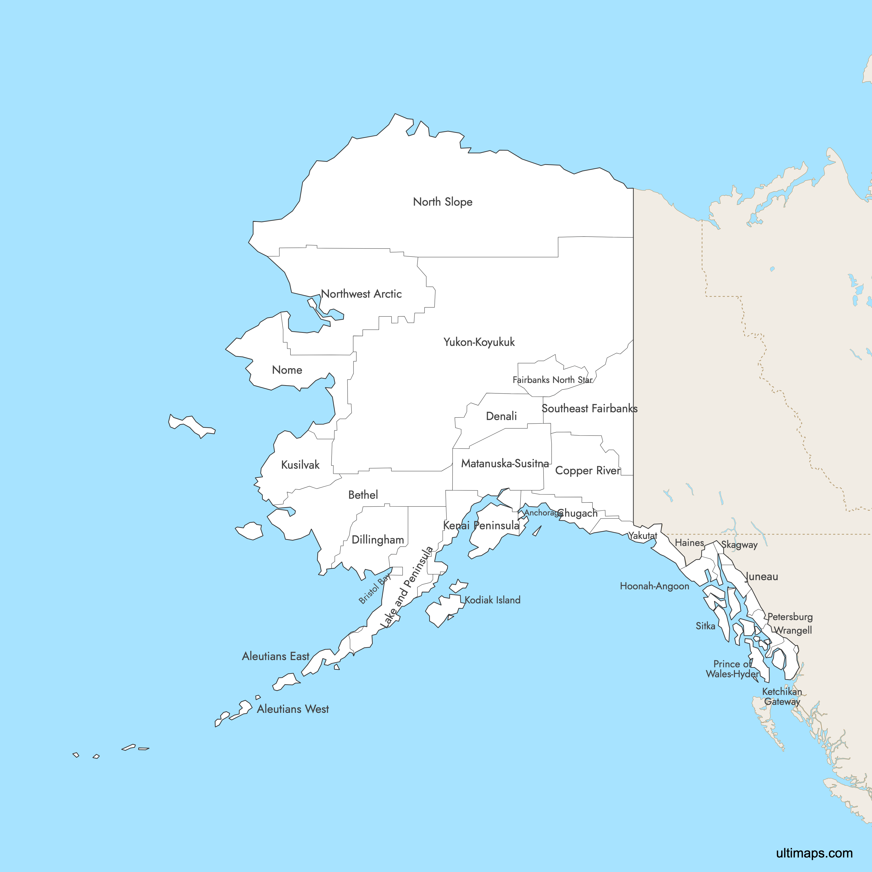
Alaska is divided into 29 boroughs and census areas, serving as the primary administrative divisions of the largest U.S. state by area at 665,384 square miles (1,723,337 km²). These regions range from the densely populated Anchorage Municipality to vast, sparsely inhabited census areas spanning Arctic tundra and volcanic island chains. Use the interactive maps below to explore Alaska's boroughs and their boundaries. Download free maps or learn more about creating a custom map of Alaska to visualize your own data.
Interactive Map of Alaska
List of Boroughs (30)
| # | Borough | County seat | Year founded |
|---|---|---|---|
| 1 | Sand Point | 1987 | |
| 2 | Unalaska | 1980 | |
| 3 | Anchorage | 1964 | |
| 4 | Bethel | 1980 | |
| 5 | Naknek | 1962 | |
| 6 | Valdez | 2019 | |
| 7 | Glennallen | 2019 | |
| 8 | Healy | 1990 | |
| 9 | Dillingham | 1980 | |
| 10 | Fairbanks | 1964 | |
| 11 | Haines | 1968 | |
| 12 | Hoonah | 1980 | |
| 13 | Juneau | 1970 | |
| 14 | Soldotna | 1964 | |
| 15 | Ketchikan | 1963 | |
| 16 | Kodiak | 1963 | |
| 17 | Hooper Bay | 1980 | |
| 18 | King Salmon | 1989 | |
| 19 | Palmer | 1964 | |
| 20 | Nome | 1980 | |
| 21 | Utqiaġvik | 1972 | |
| 22 | Kotzebue | 1986 | |
| 23 | Petersburg | 2013 | |
| 24 | Craig | 1980 | |
| 25 | Sitka | 1971 | |
| 26 | Skagway | 2007 | |
| 27 | Deltana | 1980 | |
| 28 | Wrangell | 2008 | |
| 29 | Yakutat | 1992 | |
| 30 | Galena | 1980 |
Alaska Boroughs: Key Facts
- Total number of boroughs: 29 boroughs and census areas, established under Alaska's borough system formalized in 1961 following statehood in 1959
- Most populous borough: Anchorage Municipality with 291,247 residents (2020 Census), serving as the state's largest city and main economic hub
- Least populous borough: Skagway Municipality with 1,127 residents (2020 Census)
- Largest borough by area: Yukon-Koyukuk Census Area at approximately 145,505 square miles (376,860 km²)
- Smallest borough by area: Skagway Municipality at 292 square miles (756 km²)
- Major urban centers: Anchorage (Anchorage Municipality), Fairbanks (Fairbanks North Star Borough), Juneau (Juneau Borough), Soldotna and Homer (Kenai Peninsula Borough), Wasilla and Palmer (Matanuska-Susitna Borough)
- Capital: Juneau, located in southeastern Alaska at the base of Mount Juneau on the Gastineau Channel. It is the only U.S. state capital accessible only by sea or air.
- Borders: Canada (Yukon and British Columbia) to the east and southeast; Arctic Ocean to the north; Bering Sea to the west; Gulf of Alaska and Pacific Ocean to the south
- Time zones: Primarily Alaska Time Zone (AKST/AKDT, UTC-9/UTC-8); the western Aleutian Islands use Hawaii-Aleutian Time Zone (HST/HADT, UTC-10/UTC-9)
- Boundary history: The borough system was formalized in 1961 under Alaska's constitution, adopted at statehood on January 3, 1959. Boundaries have been adjusted periodically, including the 2019 formation of the Prince of Wales-Hyder Census Area. Many remote areas remain unorganized.
Interesting Facts
- Alaska was purchased from the Russian Empire in 1867 for $7.2 million, roughly 2 cents per acre, and became the 49th U.S. state on January 3, 1959.
- Alaska has more coastline than the rest of the contiguous United States combined, stretching over 6,640 miles.
- Denali, located in Denali Borough, stands at 20,310 feet (6,190 meters) and is the highest peak in North America.
- Despite being the largest U.S. state, Alaska is the 3rd least populous, and its largest census area (Yukon-Koyukuk) alone is bigger than many U.S. states.
- Wrangell-St. Elias National Park in the Valdez-Cordova Census Area is the largest national park in the United States, featuring massive glaciated mountain ranges.
Free Downloads
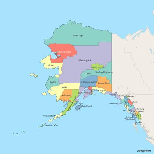 Colored Map of Alaska with Surrounding Areaspng733 KB
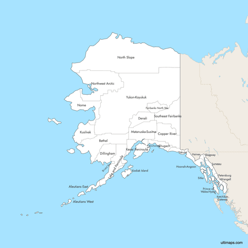 Labeled Map of Alaska with Surrounding Areaspng726 KB
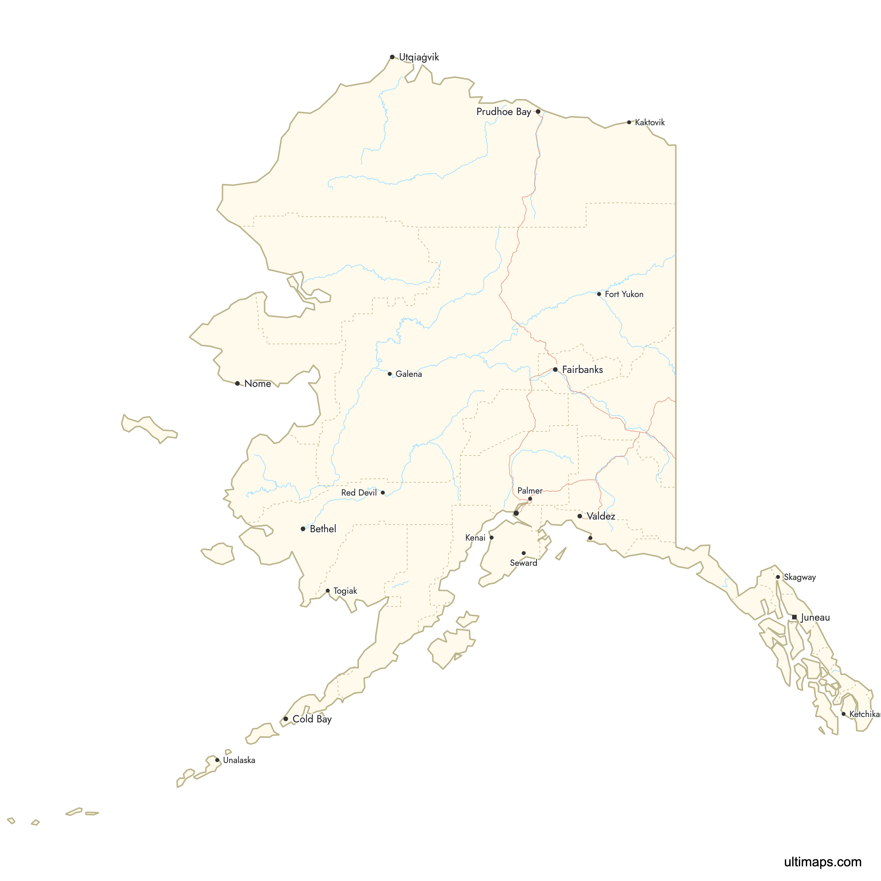
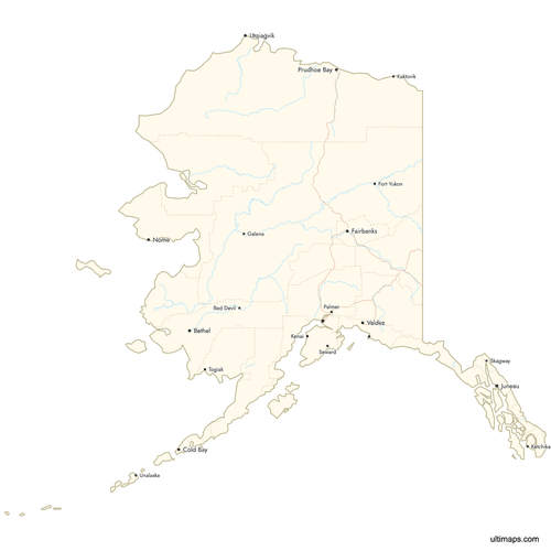 Map of Alaska with Citiespng713 KB
You can download free blank Map of Alaska and other maps in high resolution PNG, SVG and PDF formats from the blank maps section of the site: Download Blank Map of Alaska
Custom Map Features
This map supports labels.
This map supports surrounding areas, roads, rivers and cities. New
This map is divided into 30 boroughs.
Updates
Oct 23, 2024:
- Added map of Alaska Boroughs and Census Areas
Frequently Asked Questions
Alaska is divided into 29 boroughs and census areas. This system was formalized in 1961 under Alaska's constitution, adopted when Alaska became the 49th U.S. state in 1959. Unlike most other states that use counties, Alaska uses boroughs as its primary administrative divisions, and many remote areas remain unorganized.
The Yukon-Koyukuk Census Area is the largest at approximately 145,505 square miles (376,860 km²). That makes it larger than many entire U.S. states. It covers a vast stretch of Alaska's interior, including boreal forests and remote wilderness.
Skagway Municipality is the smallest borough in Alaska at 292 square miles (756 km²). It is also the least populous borough, with just 1,127 residents according to the 2020 Census.
Anchorage Municipality is the most populated borough with 291,247 residents (2020 Census). Anchorage is Alaska's largest city and its primary economic hub. It sits in the south-central part of the state along Cook Inlet.
Juneau is the capital of Alaska, located in the Juneau Borough in the extreme southeastern part of the state. It sits at the base of Mount Juneau on the Gastineau Channel. Juneau is the only U.S. state capital that is not accessible by road and can only be reached by sea or air.
Denali, North America's highest peak at 20,310 feet, is in Denali Borough along with Denali National Park. Glacier Bay National Park, a UNESCO site with tidewater glaciers, is in the Hoonah-Angoon Census Area. Wrangell-St. Elias National Park, the largest U.S. national park, is in the Valdez-Cordova Census Area. Katmai National Park, famous for brown bears at Brooks Falls, is in the Lake and Peninsula Borough.
Alaska covers 665,384 square miles (1,723,337 km²), making it by far the largest U.S. state. It is larger than Texas, California, and Montana combined. Despite its enormous size, Alaska is the 3rd least populous U.S. state.
Most of Alaska uses the Alaska Time Zone (AKST/AKDT, UTC-9/UTC-8). A small portion of the western Aleutian Islands, west of 169.30°W longitude, uses the Hawaii-Aleutian Time Zone (HST/HADT, UTC-10/UTC-9).
Alaska borders Canada (Yukon and British Columbia) to the east and southeast. It is surrounded by the Arctic Ocean to the north, the Bering Sea to the west, and the Gulf of Alaska and Pacific Ocean to the south. The Aleutian Islands chain extends roughly 1,200 miles into the Pacific Ocean.
You can use Ultimaps to create custom maps of Alaska. Color-code boroughs manually or upload your data, place pins, customize the look and feel, and export to PNG, PDF, or SVG. No sign-up required.


