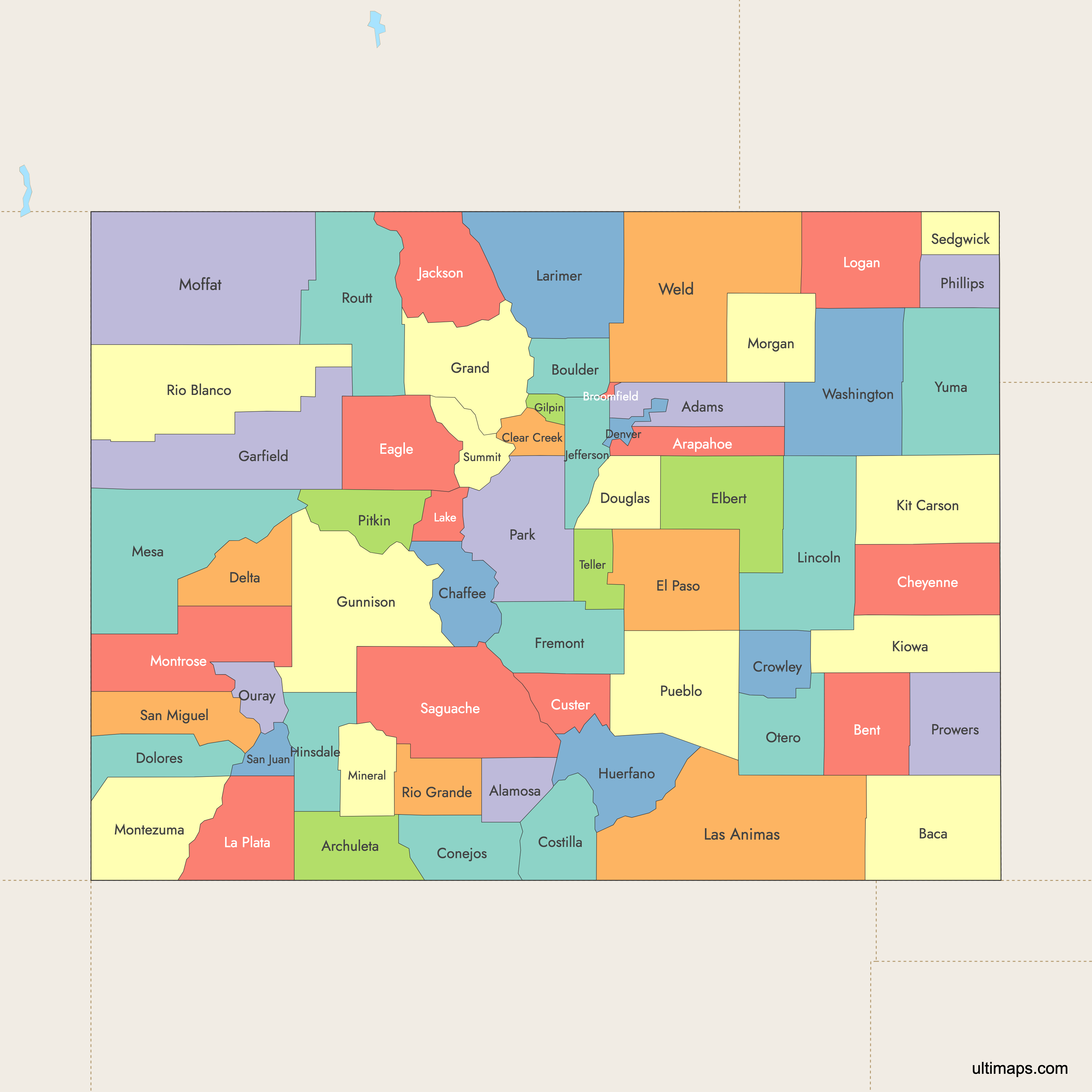
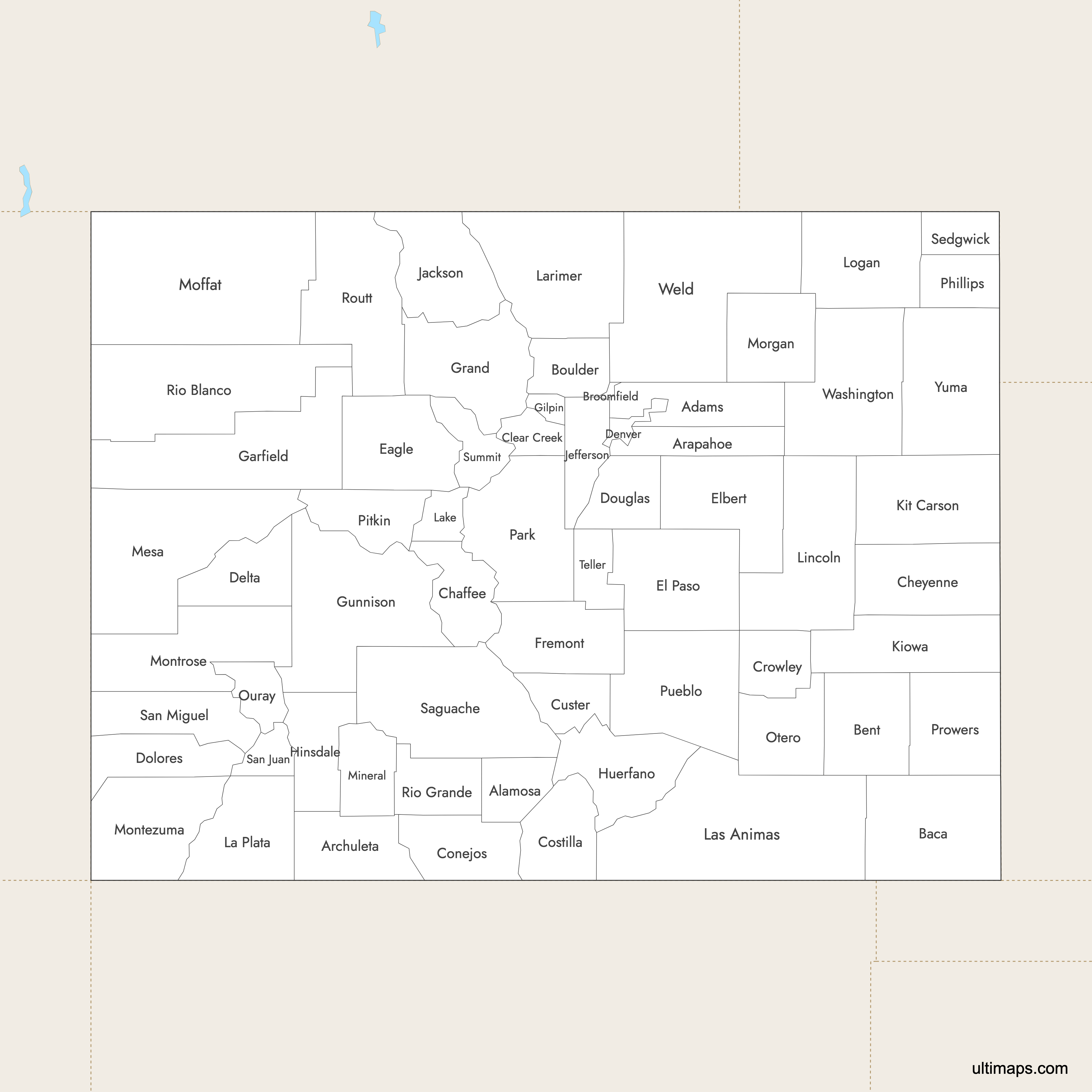
Map of Colorado Counties
Colorado is divided into 64 counties, including two consolidated city-county governments: Denver and Broomfield. These counties serve as the primary local government units, as Colorado has no civil townships. Use the interactive maps below to explore all 64 counties and their boundaries. Download free maps or learn more about creating a custom map of Colorado counties to visualize your own data.
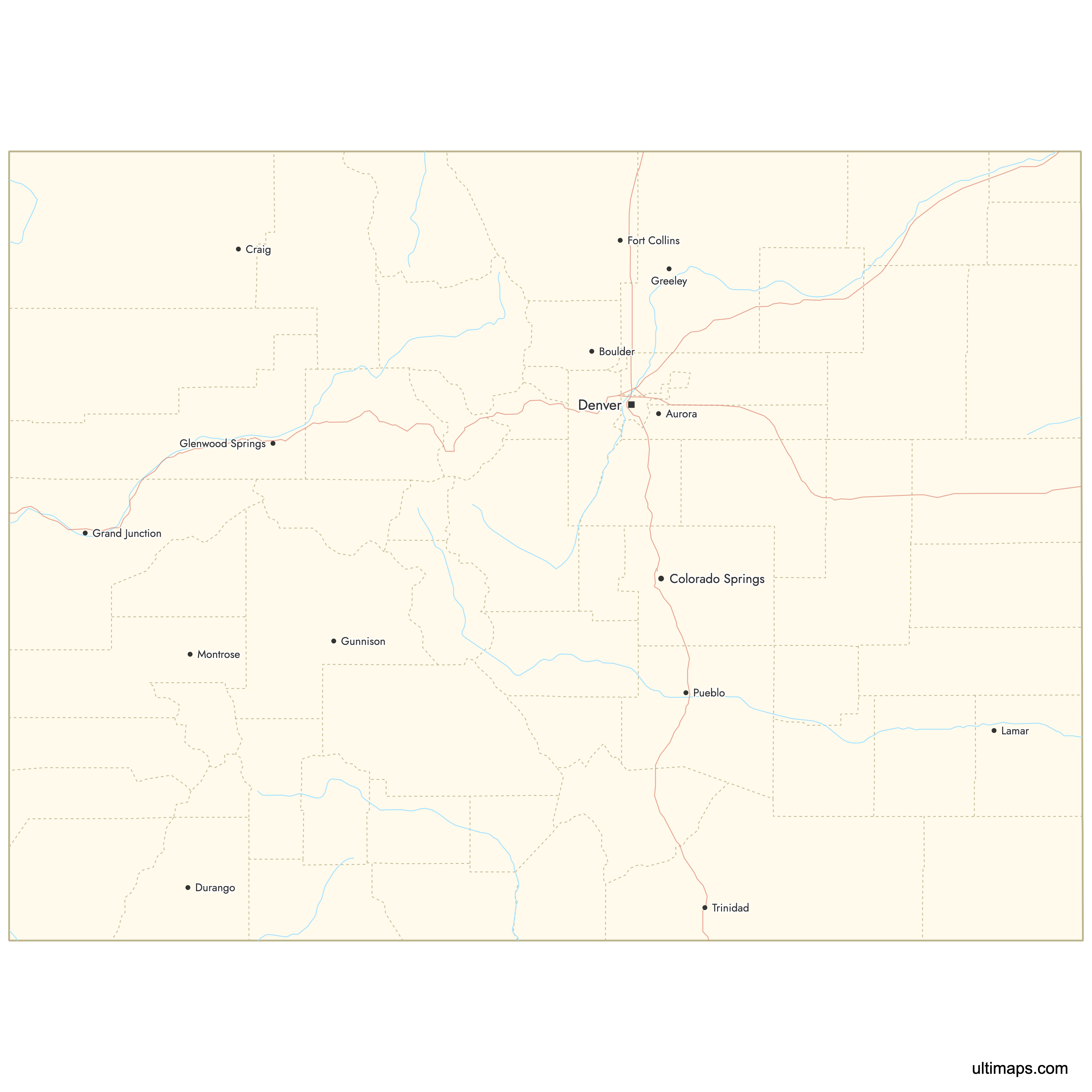
Interactive Map of Colorado Counties
List of Counties (64)
| # | County | County seat | Year founded |
|---|---|---|---|
| 1 | Brighton | 1902 | |
| 2 | Alamosa | 1913 | |
| 3 | Littleton | 1861 | |
| 4 | Pagosa Springs | 1885 | |
| 5 | Springfield | 1889 | |
| 6 | Las Animas | 1870 | |
| 7 | Boulder | 1861 | |
| 8 | Broomfield | 2001 | |
| 9 | Salida | 1879 | |
| 10 | Cheyenne Wells | 1889 | |
| 11 | Georgetown | 1861 | |
| 12 | Conejos | 1861 | |
| 13 | San Luis | 1861 | |
| 14 | Ordway | 1911 | |
| 15 | Westcliffe | 1877 | |
| 16 | Delta | 1883 | |
| 17 | Denver | 1902 | |
| 18 | Dove Creek | 1881 | |
| 19 | Castle Rock | 1861 | |
| 20 | Eagle | 1883 | |
| 21 | Colorado Springs | 1861 | |
| 22 | Kiowa | 1874 | |
| 23 | Cañon City | 1861 | |
| 24 | Glenwood Springs | 1883 | |
| 25 | Central City | 1861 | |
| 26 | Hot Sulphur Springs | 1874 | |
| 27 | Gunnison | 1877 | |
| 28 | Lake City | 1874 | |
| 29 | Walsenburg | 1861 | |
| 30 | Walden | 1909 | |
| 31 | Golden | 1861 | |
| 32 | Eads | 1889 | |
| 33 | Burlington | 1889 | |
| 34 | Durango | 1874 | |
| 35 | Leadville | 1861 | |
| 36 | Fort Collins | 1861 | |
| 37 | Trinidad | 1866 | |
| 38 | Hugo | 1889 | |
| 39 | Sterling | 1887 | |
| 40 | Grand Junction | 1883 | |
| 41 | Creede | 1893 | |
| 42 | Craig | 1911 | |
| 43 | Cortez | 1889 | |
| 44 | Montrose | 1883 | |
| 45 | Fort Morgan | 1889 | |
| 46 | La Junta | 1889 | |
| 47 | Ouray | 1877 | |
| 48 | Fairplay | 1861 | |
| 49 | Holyoke | 1889 | |
| 50 | Aspen | 1881 | |
| 51 | Lamar | 1889 | |
| 52 | Pueblo | 1861 | |
| 53 | Meeker | 1889 | |
| 54 | Del Norte | 1874 | |
| 55 | Steamboat Springs | 1877 | |
| 56 | Saguache | 1866 | |
| 57 | Silverton | 1876 | |
| 58 | Telluride | 1883 | |
| 59 | Julesburg | 1889 | |
| 60 | Breckenridge | 1861 | |
| 61 | Cripple Creek | 1899 | |
| 62 | Akron | 1887 | |
| 63 | Greeley | 1861 | |
| 64 | Wray | 1889 |
Colorado Counties: Key Facts
- Total number of counties: 64, including two consolidated city-county governments (Denver and Broomfield).
- Most populous counties: El Paso County (home to Colorado Springs) and Denver County are the state's largest urban centers, along with Jefferson County, Arapahoe County, and Adams County in the Denver metro area.
- Least populous county: Sedgwick County with a population of 2,257.
- Largest county by area: Las Animas County at 4,776 square miles (12,369 km²).
- Smallest county by area: City and County of Broomfield at 34 square miles (87 km²).
- Major urban centers: Denver (Denver County), Colorado Springs (El Paso County), Fort Collins (Larimer County, population 374,574), Boulder (Boulder County), and Golden (Jefferson County).
- State capital: City and County of Denver, which operates as a consolidated city-county government.
- Bordering states: Wyoming (north), Nebraska (northeast), Kansas (east), Oklahoma (southeast), New Mexico (south), and Utah (west).
- Time zone: Mountain Time Zone (UTC-7 standard / UTC-6 daylight saving).
- Boundary history: The original 17 counties were formed on November 1, 1861, when the Territory of Colorado was established. Rapid expansion during the 1880s mining boom brought the total to 40 by 1885. Broomfield became the 64th and newest county in 2001.
Interesting Facts
- Colorado has no civil townships. Counties function as the primary local government units across the entire state.
- Several county names reflect the region's diverse heritage: Saguache comes from a Ute word meaning "sand dunes," Pueblo is Spanish for "village," and Montezuma County is named for Aztec leader Moctezuma II.
- Broomfield is the newest county in Colorado, consolidated as a city-county in 2001, and is also the smallest by area at just 34 square miles (87 km²).
- Only two counties, Pitkin and Weld, operate under home rule charters. All other counties follow Dillon's Rule, meaning they have only the powers explicitly granted by the state.
- The 1880s mining boom triggered a wave of new counties: Dolores and Pitkin were created in 1881, followed by six more in 1883 including Montrose, Mesa, Garfield, Eagle, Delta, and San Miguel.
Free Downloads
 Colored Map of Colorado Counties with Surrounding Areaspng534 KB
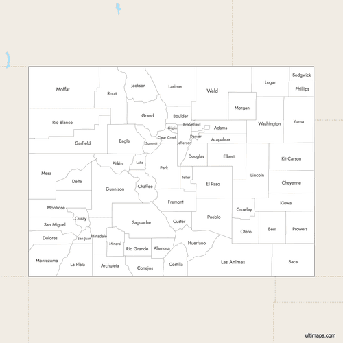 Labeled Map of Colorado Counties with Surrounding Areaspng519 KB
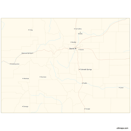 Map of Colorado Counties with Citiespng588 KB
You can download free blank Map of Colorado Counties and other maps in high resolution PNG, SVG and PDF formats from the blank maps section of the site: Download Blank Map of Colorado Counties
Custom Map Features
This map supports labels.
This map supports surrounding areas, roads, rivers and cities. New
This map is divided into 64 counties.
Updates
Oct 23, 2024:
- Added map of Colorado Counties
Frequently Asked Questions
Colorado has 64 counties. This includes two consolidated city-county governments: the City and County of Denver (the state capital) and the City and County of Broomfield (established in 2001). The original 17 counties were created on November 1, 1861, when the Territory of Colorado was formed.
Las Animas County is the largest county in Colorado by area at 4,776 square miles (12,369 km²). It is located in the southeastern part of the state. For comparison, Las Animas County alone is larger than the entire state of Rhode Island.
The City and County of Broomfield is the smallest county in Colorado at just 34 square miles (87 km²). It is also the newest county in the state, established in 2001 as a consolidated city-county government.
El Paso County and Denver County are the most populated counties in Colorado. El Paso County is home to Colorado Springs, the state's second-largest city, while Denver County contains the state capital. Other heavily populated counties include Jefferson, Arapahoe, and Adams counties in the Denver metropolitan area.
Sedgwick County is among the least populated counties in Colorado with a population of 2,257. Other sparsely populated counties include Moffat County with 13,142 residents spread across 4,756 square miles (12,318 km²) in the northwestern corner of the state.
Rocky Mountain National Park spans parts of Grand and Larimer counties. Mesa Verde National Park is in Montezuma County. Great Sand Dunes National Park covers portions of Alamosa, Rio Grande, and Saguache counties. Pikes Peak sits on the border of El Paso and Teller counties. Popular ski destinations include Aspen in Pitkin County and Breckenridge in Summit County.
All 64 Colorado counties are in the Mountain Time Zone (UTC-7 standard, UTC-6 during daylight saving time). There are no exceptions or split time zones within the state.
Colorado's first 17 counties were created on November 1, 1861, with the formation of the Territory of Colorado. The 1880s mining boom led to rapid expansion, with counties like Dolores, Pitkin, Montrose, Mesa, and Garfield created between 1881 and 1883. The most recent addition was Broomfield in 2001, bringing the total to 64.
Colorado borders six states: Wyoming to the north, Nebraska to the northeast, Kansas to the east, Oklahoma to the southeast corner, New Mexico to the south, and Utah to the west. Colorado is one of the "Four Corners" states, meeting Utah, New Mexico, and Arizona at a single point.
You can use Ultimaps to create custom maps of Colorado. Color-code counties manually or upload your data, place pins, customize the look and feel, and export to PNG, PDF, or SVG. No sign-up required.


