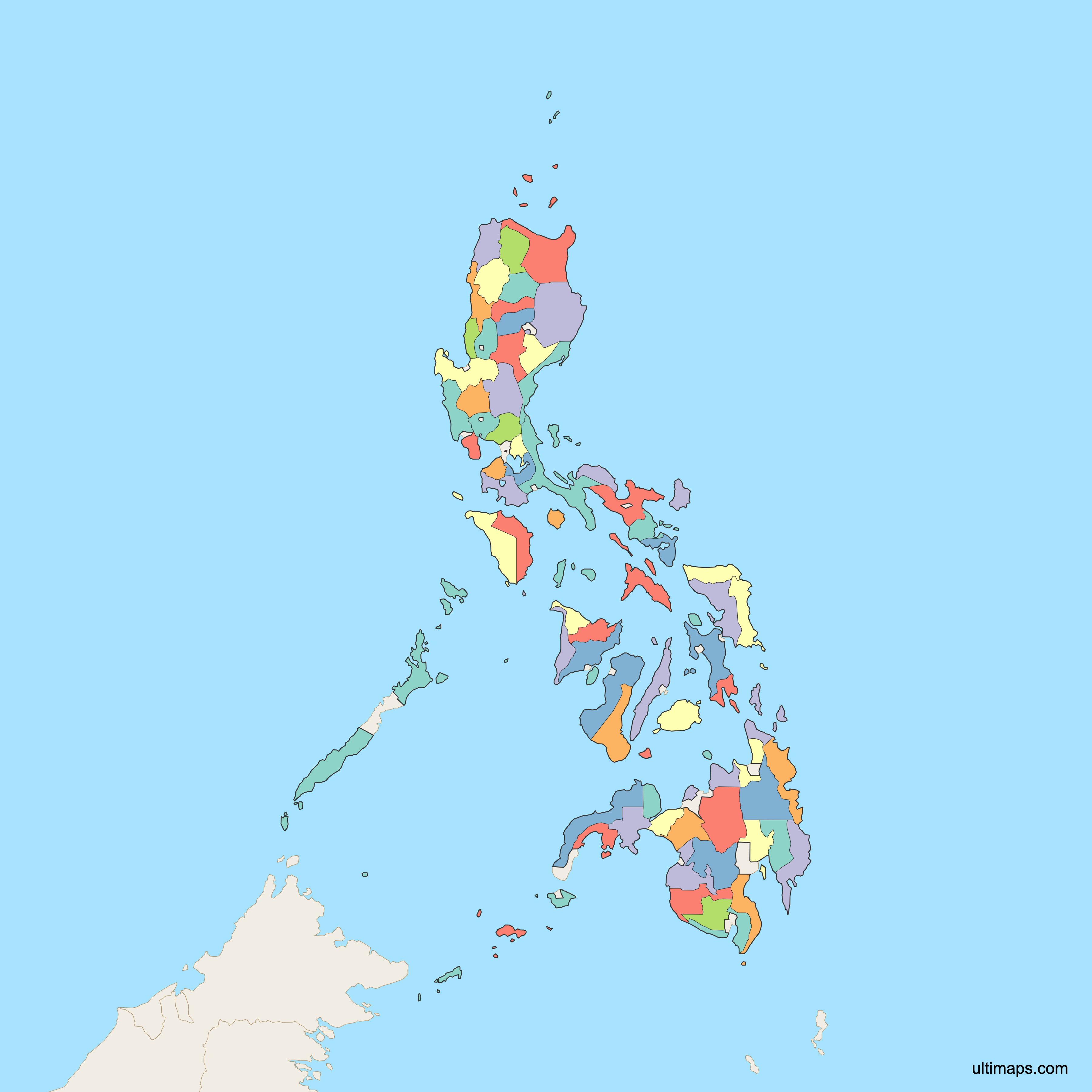
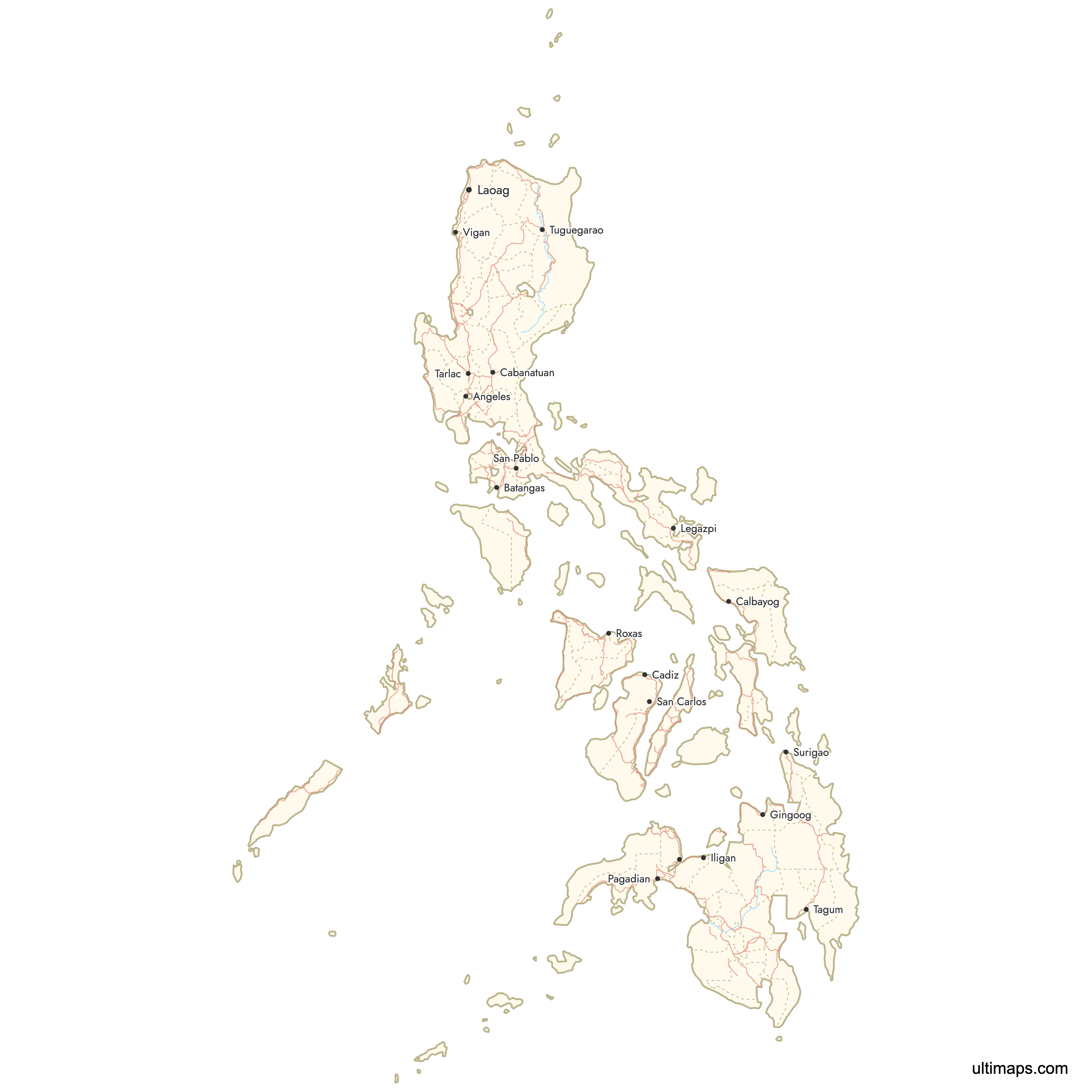
Map of Philippines Provinces
The Philippines is divided into 82 provinces, grouped across 18 administrative regions spanning three major island groups: Luzon, Visayas, and Mindanao. Each province serves as a primary administrative division of the country, with its own elected government and capital. Use the interactive maps below to explore all provinces and their boundaries. Download free maps or learn more about creating a custom map of the Philippines to visualize your own data.
Interactive Map of Philippines Provinces
List of Provinces (80)
| # | Province |
|---|---|
| 1 | |
| 2 | |
| 3 | |
| 4 | |
| 5 | |
| 6 | |
| 7 | |
| 8 | |
| 9 | |
| 10 | |
| 11 | |
| 12 | |
| 13 | |
| 14 | |
| 15 | |
| 16 | |
| 17 | |
| 18 | |
| 19 | |
| 20 | |
| 21 | |
| 22 | |
| 23 | |
| 24 | |
| 25 | |
| 26 | |
| 27 | |
| 28 | |
| 29 | |
| 30 | |
| 31 | |
| 32 | |
| 33 | |
| 34 | |
| 35 | |
| 36 | |
| 37 | |
| 38 | |
| 39 | |
| 40 | |
| 41 | |
| 42 | |
| 43 | |
| 44 | |
| 45 | |
| 46 | |
| 47 | |
| 48 | |
| 49 | |
| 50 | |
| 51 | |
| 52 | |
| 53 | |
| 54 | |
| 55 | |
| 56 | |
| 57 | |
| 58 | |
| 59 | |
| 60 | |
| 61 | |
| 62 | |
| 63 | |
| 64 | |
| 65 | |
| 66 | |
| 67 | |
| 68 | |
| 69 | |
| 70 | |
| 71 | |
| 72 | |
| 73 | |
| 74 | |
| 75 | |
| 76 | |
| 77 | |
| 78 | |
| 79 | |
| 80 |
Philippines Provinces: Key Facts
- Total number of provinces: 82 (as of 2024), organized into 18 regions across the Luzon, Visayas, and Mindanao island groups.
- Most populous province: Cebu, with 5,151,162 residents (2020 Census). Cebu City, founded in 1565, is the oldest city in the Philippines.
- Least populous province: Apayao, with 124,366 residents (2020 Census), located in the Cordillera Administrative Region of northern Luzon.
- Largest province by area: Palawan at 14,649 km² (5,656 sq mi), home to UNESCO World Heritage Sites including the Puerto Princesa Subterranean River.
- Smallest province by area: Ifugao at 2,511 km² (970 sq mi), known for the ancient Banaue Rice Terraces.
- Provinces with major urban centers: Cebu (Cebu City), Cavite (Dasmariñas, Bacoor), Bulacan (San Jose del Monte), Pampanga (Angeles City), Laguna (Calamba, Santa Rosa), and Rizal (Antipolo). Davao City, the largest city by land area at 2,443 km², is associated with Davao del Sur.
- Capital: Manila, located in the National Capital Region (NCR), which is not part of any province.
- Bordering bodies of water: South China Sea (west), Philippine Sea (east), Sulu Sea (southwest), and Celebes Sea (southeast). Maritime borders with Taiwan, Japan, Indonesia, Malaysia, and Vietnam.
- Time zone: Philippine Standard Time (UTC+8) across all provinces, with no daylight saving time.
- Boundary history: Provincial boundaries trace back to the Spanish colonial era (1565-1898) and were restructured during U.S. administration and after independence. The 18-region system dates to 1972. The most recent major change was the creation of the Bangsamoro Autonomous Region in Muslim Mindanao (BARMM) in 2019.
Interesting Facts
- The Philippines comprises 7,107 islands, making it one of the largest archipelagos in the world. Provinces are spread across these islands from Batanes in the north to Tawi-Tawi in the south.
- The Spanish galleon trade route connected Manila to Acapulco, Mexico for 250 years (1565-1815), making the Philippines a major trans-Pacific trading hub.
- Palawan holds two UNESCO World Heritage Sites: the Puerto Princesa Subterranean River, the world's longest navigable underground river at 8 km, and Tubbataha Reefs Natural Park, a 33,000-hectare marine sanctuary with over 600 fish species.
- Mayon Volcano in Albay province is famous for its near-perfect cone shape, stands at 2,463 meters, and has erupted more than 50 times in recorded history.
- The term "province" (lalawigan in Filipino) derives from Spanish colonial administration. Before Spanish rule, the islands were organized into barangays and rajanates.
Free Downloads
 Colored Map of Philippines Provinces with Surrounding Areaspng672 KB
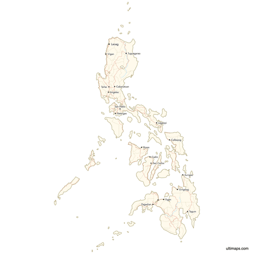 Map of Philippines Provinces with Citiespng851 KB
You can download free blank Map of Philippines Provinces and other maps in high resolution PNG, SVG and PDF formats from the blank maps section of the site: Download Blank Map of Philippines Provinces
Custom Map Features
This map supports surrounding areas, roads, rivers and cities. New
This map is divided into 80 provinces.
Updates
May 14, 2026:
- Added map of Philippines Provinces with surrounding countries, cities, roads, rivers and lakes
Frequently Asked Questions
The Philippines has 82 provinces as of 2024. These provinces are organized into 18 administrative regions across three major island groups: Luzon (8 regions), Visayas (4 regions), and Mindanao (6 regions). The National Capital Region (Metro Manila) and certain independent cities are not part of any province.
Palawan is the largest province at 14,649 km² (5,656 sq mi). Located in the Mimaropa region, Palawan is home to the Puerto Princesa Subterranean River and Tubbataha Reefs Natural Park, both UNESCO World Heritage Sites.
Ifugao is the smallest province at 2,511 km² (970 sq mi). Part of the Cordillera Administrative Region in northern Luzon, Ifugao is best known for the Banaue Rice Terraces, a 2,000-year-old UNESCO World Heritage Site often called the Eighth Wonder of the World.
Cebu is the most populated province with 5,151,162 residents according to the 2020 Census. Its capital, Cebu City, was founded in 1565 and is the oldest city in the Philippines. Notable landmarks include Magellan's Cross and the Basilica del Santo Niño.
Apayao is the least populated province with 124,366 residents (2020 Census). It is located in the Cordillera Administrative Region in the mountainous interior of northern Luzon.
The Chocolate Hills, a formation of over 1,200 symmetrical mounds, are in Bohol province (Central Visayas). Mayon Volcano, famous for its perfect cone shape at 2,463 meters, is in Albay province (Bicol Region). The historic colonial town of Vigan, a UNESCO World Heritage Site, is in Ilocos Sur province (Ilocos Region). Mount Apo, the highest peak in the Philippines at 2,956 meters, straddles Davao del Sur and Cotabato provinces.
The 82 provinces are grouped into 18 administrative regions, a system established in 1972. Only the Bangsamoro Autonomous Region in Muslim Mindanao (BARMM), created in 2019, has its own autonomous elected government. The other regions serve primarily as administrative groupings for planning and statistical purposes.
The Philippines is bordered by the South China Sea to the west, the Philippine Sea to the east, the Sulu Sea to the southwest, and the Celebes Sea to the southeast. The country shares maritime borders with Taiwan (north), Japan (northeast), Indonesia (south), Malaysia (southwest), and Vietnam (west).
All 82 provinces use Philippine Standard Time (UTC+8). The country does not observe daylight saving time, so the time remains consistent year-round across all provinces and regions.
You can use Ultimaps to create custom maps of the Philippines. Color-code provinces manually or upload your data, place pins, customize the look and feel, and export to PNG, PDF, or SVG. No sign-up required.