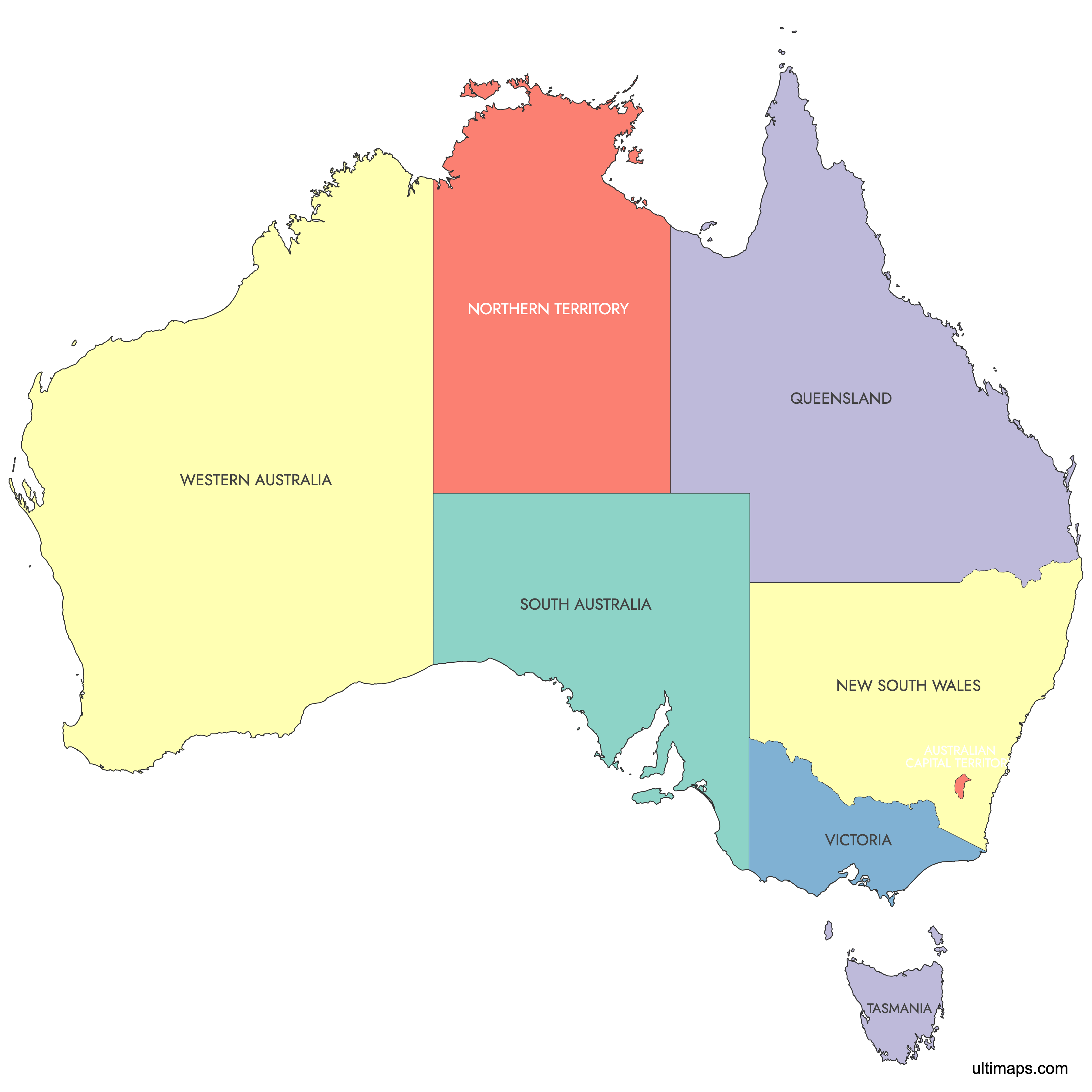
Map of Australia States
Australia is divided into 6 states and 2 mainland territories, covering a total area of 7,741,220 km² (2,989,464 sq mi). These administrative divisions range from the vast Western Australia to the compact Australian Capital Territory, which contains the national capital Canberra. Use the interactive maps below to explore states and territories and their boundaries. Download free maps or learn more about creating a custom map of Australia to visualize your own data.
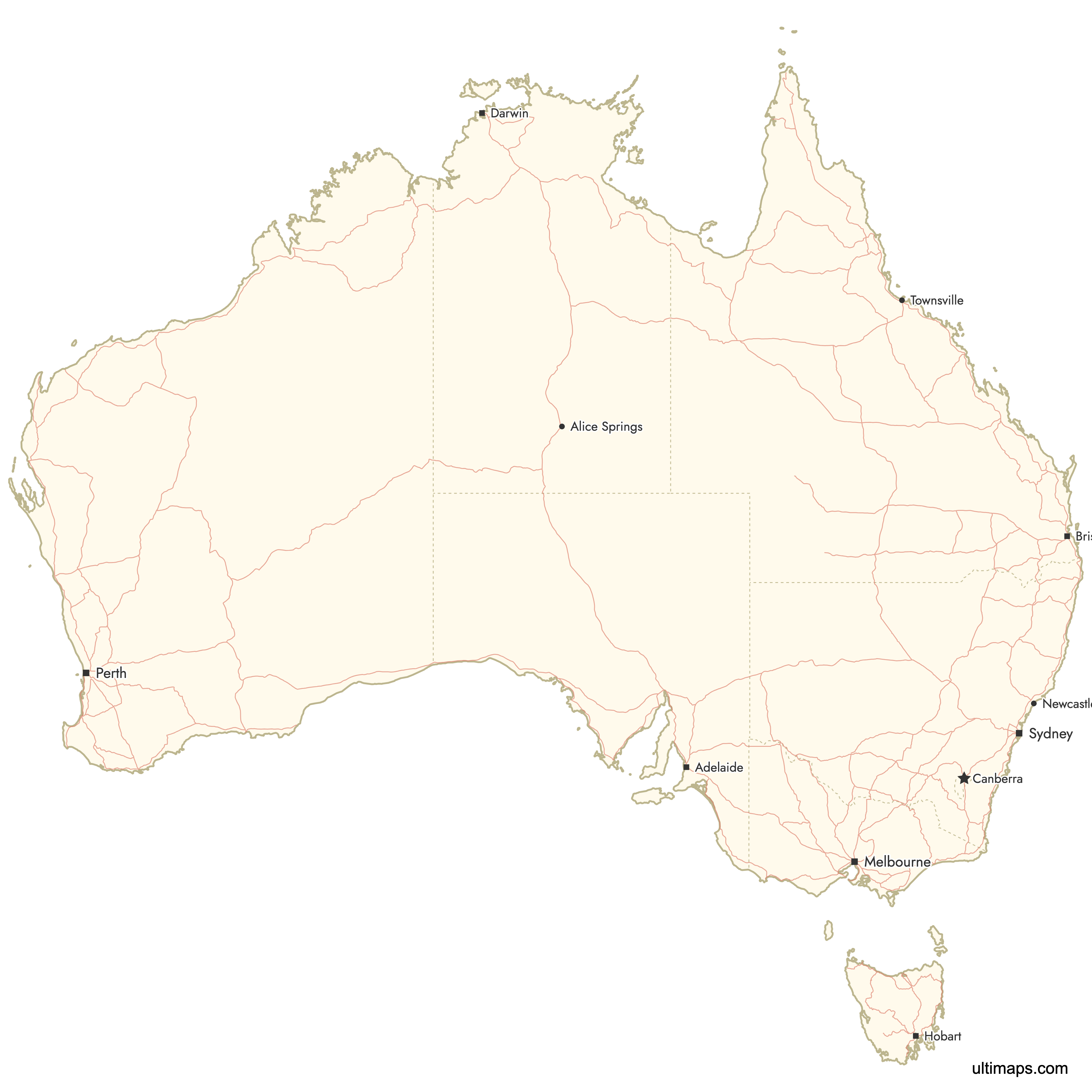
Interactive Map of Australia States
List of States/Territories (8)
| # | State/Territory |
|---|---|
| 1 | |
| 2 | |
| 3 | |
| 4 | |
| 5 | |
| 6 | |
| 7 | |
| 8 |
Australia States and Territories: Key Facts
- Total number of states/territories: 6 states and 2 mainland territories, plus 7 external territories
- Most populous state: New South Wales with Sydney (approximately 5.3 million in the greater metropolitan area, 2021 Census)
- Least populous state/territory: Tasmania with approximately 570,000 residents (2021 Census)
- Largest state by area: Western Australia at 2,529,875 km² (976,790 sq mi)
- Smallest state/territory by area: Australian Capital Territory at 2,358 km² (910 sq mi)
- States/territories with major urban centers: New South Wales (Sydney, Newcastle), Victoria (Melbourne, Geelong), Queensland (Brisbane, Gold Coast), Western Australia (Perth), South Australia (Adelaide)
- Capital: Canberra, located in the Australian Capital Territory at 35°16'S, 149°08'E
- Bordering waters: Indian Ocean (west), South Pacific Ocean (east), Coral Sea (northeast), Arafura and Timor Seas (northwest), Tasman Sea (southeast), Great Australian Bight (south)
- Time zones: Three main zones including Australian Eastern Standard Time (UTC+10), Australian Central Standard Time (UTC+9:30), and Australian Western Standard Time (UTC+8)
- Historical boundaries: Current divisions established through British colonization from 1788, federation in 1901, Northern Territory separation from South Australia in 1911, and Australian Capital Territory creation in 1911
Interesting Facts
- Australia is the world's smallest continent, flattest, and driest inhabited continent, with approximately 70% covered by the Western Plateau including the Great Victoria, Gibson, and Simpson deserts.
- The country has over 8,000 islands, with Tasmania being the largest at 68,401 km² (26,410 sq mi).
- The Great Barrier Reef off Queensland is the world's largest coral reef system, spanning 344,400 km² (133,000 sq mi) and stretching 2,600 km along the coast.
- Australia's coastline extends 35,877 km (excluding islands) and the country claims an exclusive economic zone of 8,148,250 km².
- Indigenous Australians established approximately 250 language groups across the continent before European colonization.
Free Downloads
You can download free blank Map of Australia States and other maps in high resolution PNG, SVG and PDF formats from the blank maps section of the site: Download Blank Map of Australia States
Custom Map Features
This map supports labels.
This map is divided into 8 states/territories.
Updates
Apr 14, 2024:
- Added map of Australia (without external territories)
Frequently Asked Questions
Australia has 6 states (New South Wales, Queensland, South Australia, Tasmania, Victoria, and Western Australia) and 2 mainland territories (Australian Capital Territory and Northern Territory). The country also administers 7 external territories including Christmas Island, Norfolk Island, and the Australian Antarctic Territory.
Western Australia is the largest state by area at 2,529,875 km² (976,790 sq mi). It covers much of the Western Plateau and contains vast arid and semi-arid landscapes spanning approximately 2.7 million km².
The Australian Capital Territory is the smallest at 2,358 km² (910 sq mi). It was created in 1911 specifically to house the national capital Canberra and is entirely surrounded by New South Wales.
New South Wales is the most populous state, anchored by Sydney with approximately 5.3 million residents in the greater metropolitan area (2021 Census). Newcastle, also in New South Wales, has around 500,000 residents.
Sydney and its iconic Opera House are in New South Wales. The Great Barrier Reef, spanning 2,600 km with 2,900 individual reefs, lies off the Queensland coast. Uluru (Ayers Rock) is located in the Northern Territory within Uluṟu-Kata Tjuṯa National Park. Mount Kosciuszko, Australia's highest point at 2,228 m, sits in the Great Dividing Range in New South Wales.
You can use Ultimaps to create custom maps of Australia. Color-code states and territories manually or upload your data, place pins, customize the look and feel, and export to PNG, PDF, or SVG. No sign-up required.
Canberra is the capital of Australia, located in the Australian Capital Territory at coordinates 35°16'S, 149°08'E. It has a population of approximately 503,000 (2021 Census) and was purpose-built as a planned capital city.
Australia spans three main time zones: Australian Eastern Standard Time (AEST, UTC+10) covering the most populated eastern states, Australian Central Standard Time (ACST, UTC+9:30) for South Australia and Northern Territory, and Australian Western Standard Time (AWST, UTC+8) for Western Australia. Tasmania, ACT, New South Wales, Victoria, and Queensland observe daylight saving time.
Australia's largest cities by population (2021 Census) are Sydney (5.3 million), Melbourne (5 million), Brisbane (2.5 million), Perth (2.1 million), Adelaide (1.4 million), Gold Coast (700,000), Canberra (503,000), and Hobart (250,000).
Australia is surrounded by the Indian Ocean to the west, South Pacific Ocean to the east, Coral Sea to the northeast, Arafura and Timor Seas to the northwest (separating Australia from Indonesia, Papua New Guinea, and East Timor), Tasman Sea to the southeast (toward New Zealand), and the Great Australian Bight to the south. The coastline extends 35,877 km excluding islands.