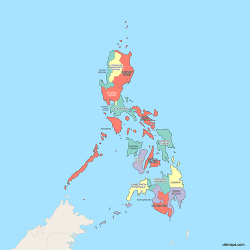
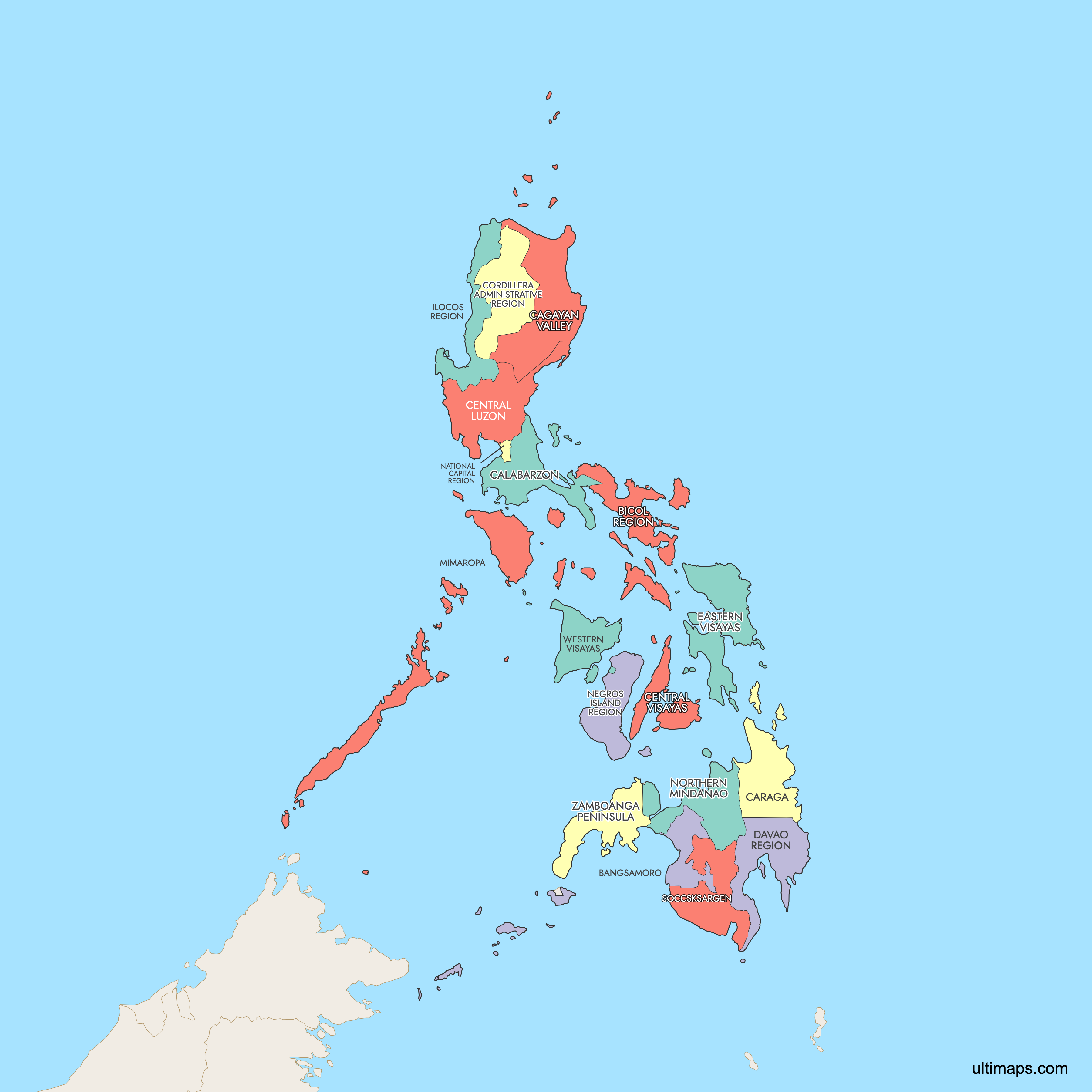
Map of Philippines Regions
The Philippines is divided into 18 administrative regions, grouped into three major island clusters: Luzon (8 regions), Visayas (4 regions), and Mindanao (6 regions). These regions serve as the primary framework for government administration, planning, and statistical reporting across the archipelago's 7,107 islands. Use the interactive maps below to explore all regions and their boundaries. Download free maps or learn more about creating a custom map of the Philippines to visualize your own data.
Interactive Map of Philippines Regions
List of Regions (18)
| # | Region |
|---|---|
| 1 | |
| 2 | |
| 3 | |
| 4 | |
| 5 | |
| 6 | |
| 7 | |
| 8 | |
| 9 | |
| 10 | |
| 11 | |
| 12 | |
| 13 | |
| 14 | |
| 15 | |
| 16 | |
| 17 | |
| 18 |
Philippines Regions: Key Facts
- Total number of regions: 18 administrative regions, grouped into three island clusters: Luzon (8), Visayas (4), and Mindanao (6)
- Most populous region: Calabarzon (Region IV-A) with 16,933,234 people (2020 Census)
- Least populous region: Cordillera Administrative Region (CAR) with 1,808,985 people (2020 Census)
- Largest region by area: Mimaropa (Southwestern Tagalog Region) at 29,620.90 km² (11,436.69 sq mi)
- Smallest region by area: National Capital Region (NCR) at 636.00 km² (245.56 sq mi)
- Regions with major urban centers: NCR (Manila, Quezon City, Makati), Calabarzon (Cavite, Laguna, Batangas), Central Luzon (Angeles City, San Fernando), Central Visayas (Cebu City)
- Capital: Manila, located in the National Capital Region (NCR); each region has a designated regional center
- Bordering countries and bodies of water: Taiwan to the north, Vietnam to the west across the South China Sea, Indonesia and Malaysia to the south; surrounded by the Philippine Sea (east), Sulu Sea and Celebes Sea (southwest)
- Time zone: Philippines Time (PHT, UTC+8) across all regions
- Current boundaries established: The 18-region structure took effect on June 30, 2024, with the creation of the Negros Island Region (NIR) from parts of Regions VI and VII
Interesting Facts
- Nearly 40% of the national population lives in just three regions: Calabarzon, NCR, and Central Luzon, which together account for over 43 million people (2020 Census).
- NCR has a population density of 20,247 people per km², while the Cordillera Administrative Region has just 89 people per km², making NCR roughly 227 times denser.
- BARMM (Bangsamoro Autonomous Region in Muslim Mindanao) is the only autonomous region in the Philippines, established through a 2019 plebiscite.
- Davao City in Region XI is the largest city in the Philippines by land area and is known as the durian capital of the country.
- The Philippines is home to two UNESCO World Heritage Sites tied to specific regions: the Puerto Princesa Subterranean River in Mimaropa (Palawan) and Tubbataha Reefs Natural Park, also in Palawan.
Free Downloads
 Colored Map of Philippines Regions with Surrounding Areaspng780 KB
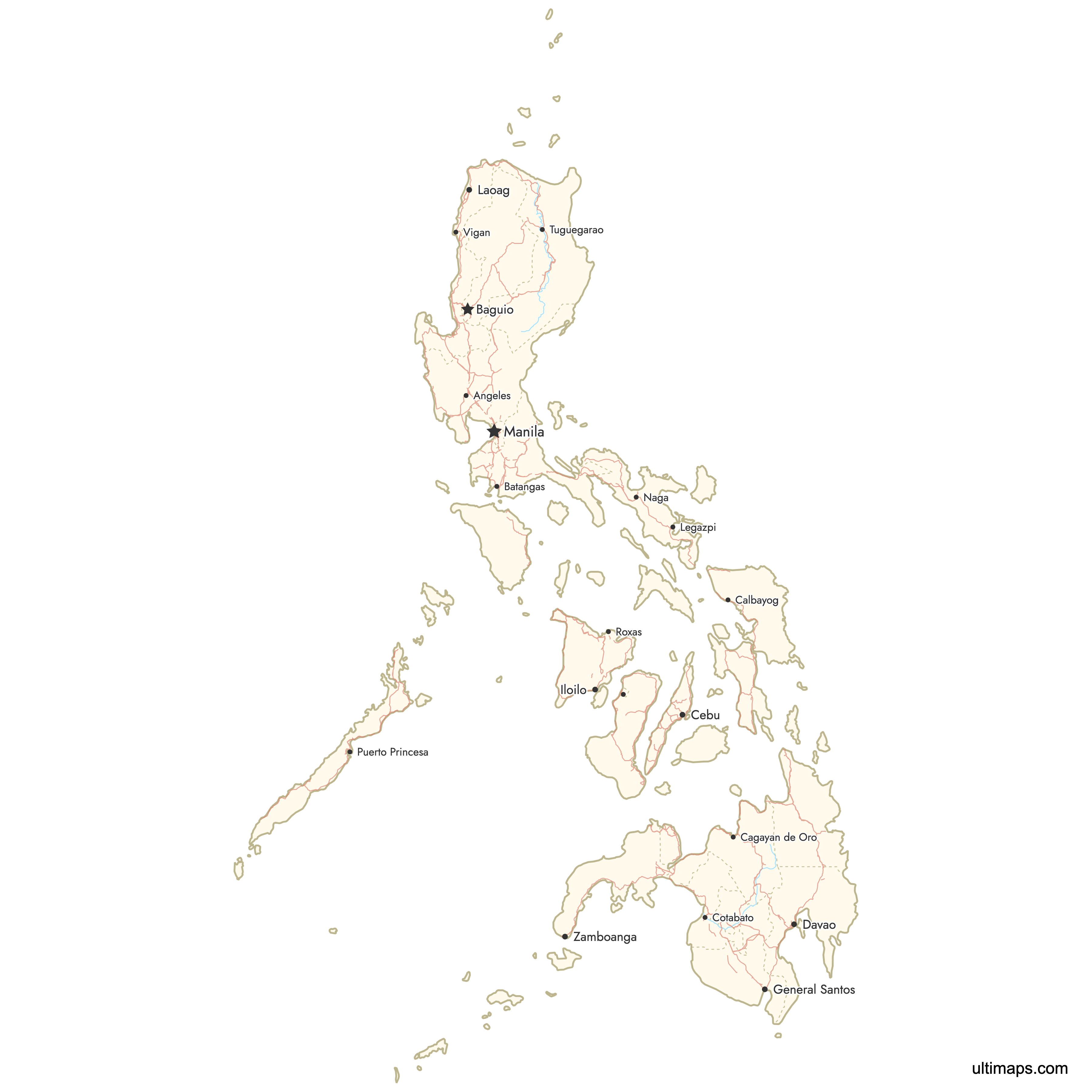
 Map of Philippines Regions with Citiespng824 KB
You can download free blank Map of Philippines Regions and other maps in high resolution PNG, SVG and PDF formats from the blank maps section of the site: Download Blank Map of Philippines Regions
Custom Map Features
This map supports labels.
This map supports surrounding areas, roads, rivers and cities. New
This map is divided into 18 regions.
Updates
Apr 23, 2026:
- Added map of the Philippines Regions with surrounding countries, cities and roads
Frequently Asked Questions
The Philippines has 18 administrative regions as of June 30, 2024. These are grouped into three major island clusters: Luzon (8 regions), Visayas (4 regions), and Mindanao (6 regions). The most recent change was the creation of the Negros Island Region (NIR), bringing the total from 17 to 18.
Mimaropa (Southwestern Tagalog Region) is the largest region by area at 29,620.90 km² (11,436.69 sq mi). It covers the island provinces of Mindoro, Marinduque, Romblon, and Palawan. Palawan alone is home to the Puerto Princesa Subterranean River and Tubbataha Reefs Natural Park, both UNESCO World Heritage Sites.
The National Capital Region (NCR), also known as Metro Manila, is the smallest region at just 636.00 km² (245.56 sq mi). Despite its small size, it contains 13 cities including Manila, Quezon City, and Makati. NCR has a population density of 20,247 people per km², making it by far the most densely populated region.
Calabarzon (Region IV-A) is the most populous region with 16,933,234 people according to the 2020 Census. It is located just south of Metro Manila and includes the provinces of Cavite, Laguna, Batangas, Rizal, and Quezon. NCR follows as the second most populous with 14,001,751 people.
Mayon Volcano, known for its near-perfect cone shape, is in the Bicol Region (Region V) in Albay province. The Chocolate Hills, consisting of over 1,200 symmetrical mounds, are in Bohol within Central Visayas (Region VII). Cebu City, the oldest city in the Philippines and home to Magellan's Cross, is also in Central Visayas. Baguio, the country's Summer Capital, is in the Cordillera Administrative Region (CAR).
The Philippines is traditionally divided into three island groups: Luzon in the north (8 regions including NCR and Calabarzon), Visayas in the center (4 regions including Central Visayas and Western Visayas), and Mindanao in the south (6 regions including Davao and BARMM). Luzon is the largest and most populous island group, while Mindanao is the second largest by land area.
BARMM stands for Bangsamoro Autonomous Region in Muslim Mindanao. It is the only autonomous region in the Philippines, established through a plebiscite in 2019. Unlike other regions that function purely as administrative groupings, BARMM has a degree of self-governance. It is located in the southwestern part of Mindanao.
The current 18-region structure took effect on June 30, 2024. The change was driven by the creation of the Negros Island Region (NIR), which was carved out of parts of Western Visayas (Region VI) and Central Visayas (Region VII). Before 2019, the Philippines had 17 regions, following the establishment of BARMM.
You can use Ultimaps to create custom maps of the Philippines. Color-code regions manually or upload your data, place pins, customize the look and feel, and export to PNG, PDF, or SVG. No sign-up required.