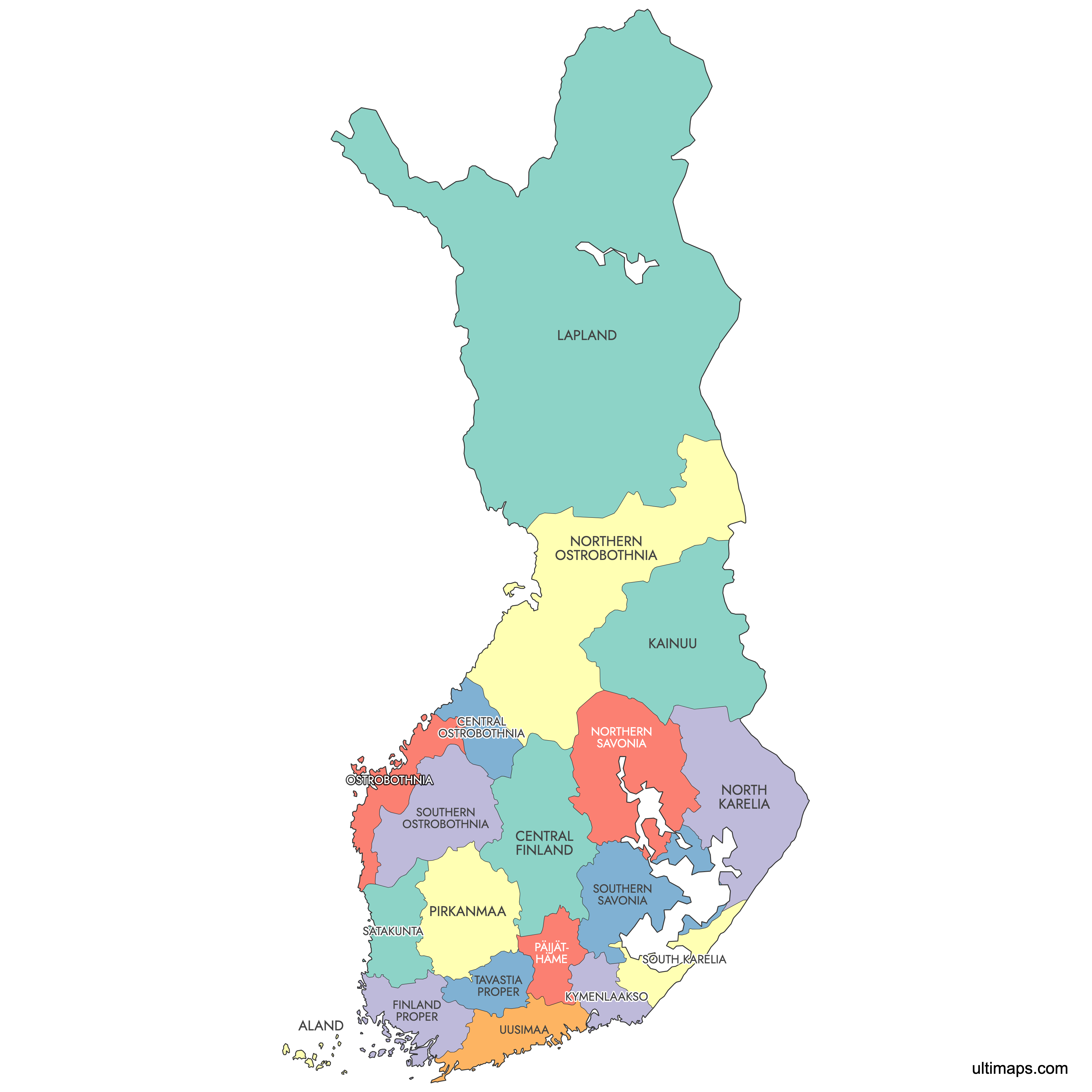
Map of Finland Regions
Finland is divided into 19 regions including 1 autonomous region of Åland, each playing a significant role in local governance, economic planning, and service provision. Use the interactive maps below to explore these regions and their boundaries. Download free maps or learn more about creating a custom map of Finland to visualize your own data.
Interactive Map of Finland Regions
List of Regions (19)
| # | Region |
|---|---|
| 1 | |
| 2 | |
| 3 | |
| 4 | |
| 5 | |
| 6 | |
| 7 | |
| 8 | |
| 9 | |
| 10 | |
| 11 | |
| 12 | |
| 13 | |
| 14 | |
| 15 | |
| 16 | |
| 17 | |
| 18 | |
| 19 |
Finland Regions: Key Facts
- Total number of regions: 19
- Most populous region: Uusimaa (includes Helsinki) - approx. 1,782,300 residents as of 2024
- Least populous region: Central Ostrobothnia - 67,723 residents
- Total number of municipalities: 309
- Special autonomous region: Åland, predominantly Swedish-speaking
- Semi-autonomous area: Sami Domicile Area in Lapland
Interesting Facts
- Uusimaa, including the capital city Helsinki, is one of the most densely populated regions.
- Åland has a unique status with greater independence in governance.
- The regional system replaced former provincial boundaries in the late 1990s.
- Finland's regions are further divided into 70 sub-regions.
Free Downloads
You can download free blank Map of Finland Regions and other maps in high resolution PNG, SVG and PDF formats from the blank maps section of the site: Download Blank Map of Finland Regions
Custom Map Features
This map supports labels.
This map is divided into 19 regions.
Updates
Sep 15, 2025:
- Added map of Finland regions with labels
Frequently Asked Questions
There are 19 regions in Finland.
Finland's 19 regions are organized into 70 sub-regions and 309 municipalities. Additionally, there are 21 Wellbeing services counties responsible for health, social, and emergency services.
You can use Ultimaps Studio to create custom maps of Finland. Color-code regions manually or upload data, place pins, customize the look and feel, and export to PNG, PDF, or SVG.
The Sami Domicile Area is a semi-autonomous region in Lapland that allows the Sami people to manage their own cultural and language affairs.