Sweden Map with Counties
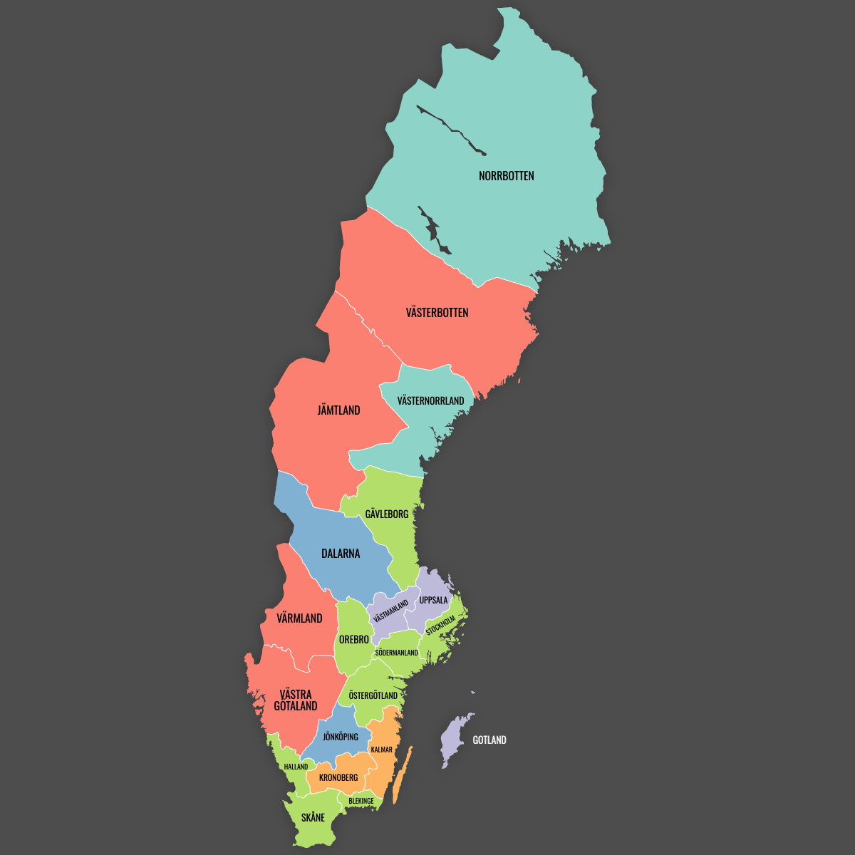
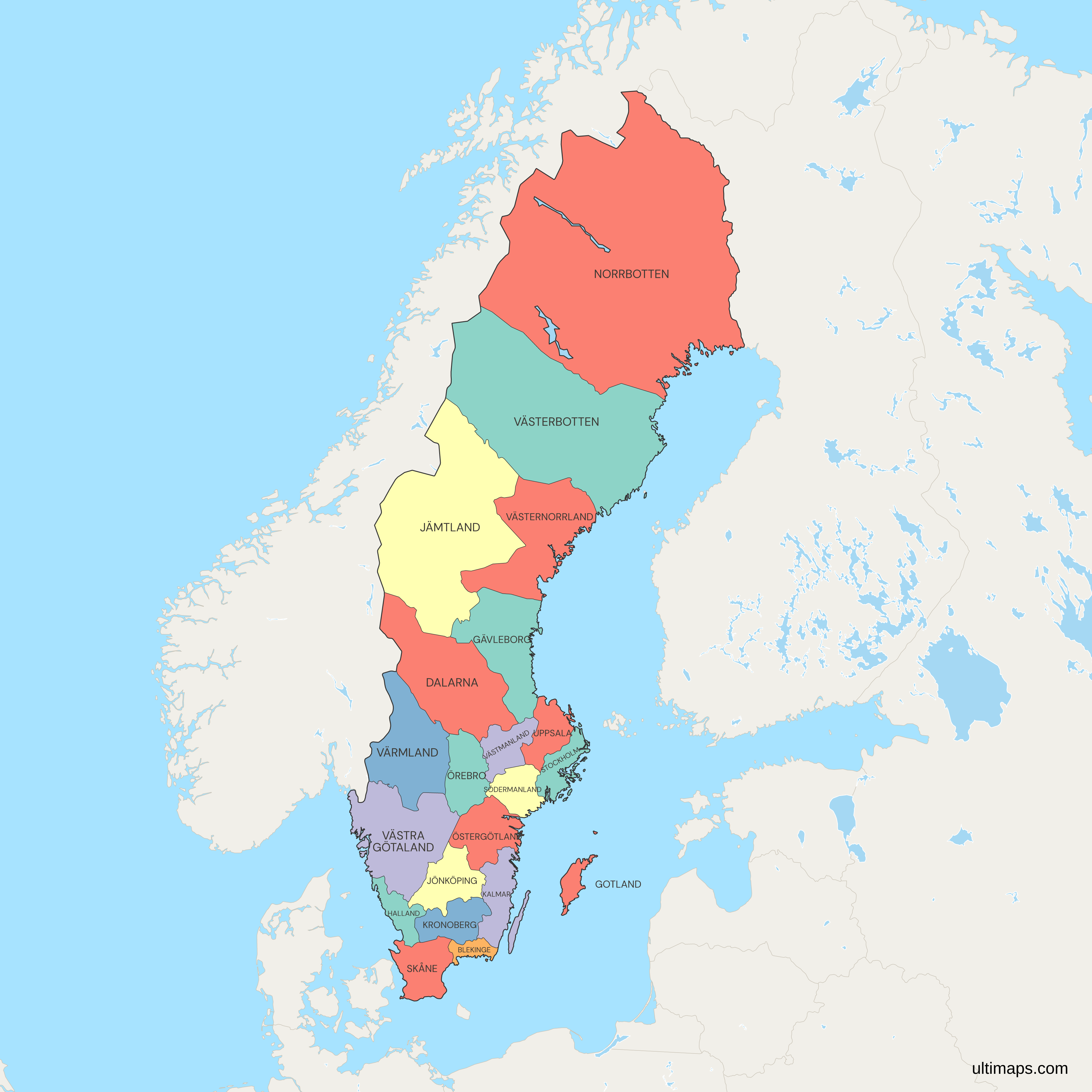
Sweden has had 21 counties (län) since Skåne was formed in 1997 and Västra Götaland in 1998, and each one is a separate shape on this map. Each county has a state county administrative board (länsstyrelse). The same 21 areas also form Sweden's regions (regioner), whose elected assemblies run health care and public transport.
Stockholm, the national capital, is in Stockholm County. According to Statistics Sweden (SCB), it is the most populous county, with more than 2.4 million residents on 31 December 2024. That is about 23 percent of the national total of 10.59 million. Gotland, a county made up mainly of one large island, had about 61,000 residents on 31 December 2024, the smallest population of any county. Norrbotten, on the borders with Norway and Finland, covers more than 97,000 km² (about 37,500 sq mi) of land according to Statistics Sweden, the most of any county. You can use the editor to color each county with figures you type or paste in.
Interactive Sweden Map with Counties
List of Counties (21)
| # | County |
|---|---|
| 1 | Blekinge |
| 2 | Dalarna |
| 3 | Gävleborg |
| 4 | Gotland |
| 5 | Halland |
| 6 | Jämtland |
| 7 | Jönköping |
| 8 | Kalmar |
| 9 | Kronoberg |
| 10 | Norrbotten |
| 11 | Örebro |
| 12 | Östergötland |
| 13 | Skåne |
| 14 | Södermanland |
| 15 | Stockholm |
| 16 | Uppsala |
| 17 | Värmland |
| 18 | Västerbotten |
| 19 | Västernorrland |
| 20 | Västmanland |
| 21 | Västra Götaland |
Sweden Counties: Key Facts
- Total number of counties: 21 (län). That is more than Finland with 19 regions or Denmark with 5
- Most populous county: Stockholm County, more than 2.4 million residents (SCB, 31 December 2024)
- Least populous county: Gotland, about 61,000 residents (SCB, 31 December 2024)
- Largest county by area: Norrbotten, more than 97,000 km² (about 37,500 sq mi) of land (Statistics Sweden)
- Smallest county by area: Blekinge, about 2,930 km² (1,130 sq mi) of land (Statistics Sweden)
- Counties with major urban centers: Stockholm (Stockholm), Västra Götaland (Gothenburg, Trollhättan), Skåne (Malmö, Helsingborg), Uppsala (Uppsala), Östergötland (Linköping, Norrköping), Västmanland (Västerås), Örebro (Örebro), Västerbotten (Umeå)
- Capital: Stockholm, the seat of the government and the Riksdag, is in Stockholm County
- Borders: Norway lies to the west and shares a land border with Västra Götaland, Värmland, Dalarna, Jämtland, Västerbotten and Norrbotten. Finland lies to the east, along Norrbotten's border, which follows the Torne and Muonio rivers. Denmark lies across the Øresund, and the Øresund Bridge has linked it to Skåne since 2000. The coast faces the Skagerrak, the Kattegat, the Baltic Sea and the Gulf of Bothnia
- Time zone: Central European Time (UTC+1), and Central European Summer Time (UTC+2) in summer
- Historical note: The county system dates from the Instrument of Government of 1634. Sweden had 24 counties until Kristianstad and Malmöhus merged into Skåne on 1 January 1997. On 1 January 1998, Göteborg och Bohus, Älvsborg and most of Skaraborg became Västra Götaland. The most recent change moved Heby municipality from Västmanland to Uppsala County on 1 January 2007
Interesting Facts
- SCB's two-digit county codes run from 01 (Stockholm) to 25 (Norrbotten). Codes 02, 11, 15 and 16 are unused because they belonged to counties that were abolished.
- Sweden also has 25 historical provinces (landskap), which do not follow county borders. For example, the province of Småland is split mainly between Jönköping, Kronoberg and Kalmar counties.
- Gotland is a county, a region and a single municipality at once. Region Gotland handles both municipal and regional duties.
- Kiruna, in Norrbotten, is moving its town center about 3 km east because of the LKAB iron ore mine. The new center opened in 2022.
Free Downloads
Free for personal and commercial use with a credit to Ultimaps. See the license terms for details.
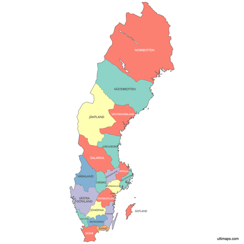 Colored Sweden Map with Countiespng488 KB
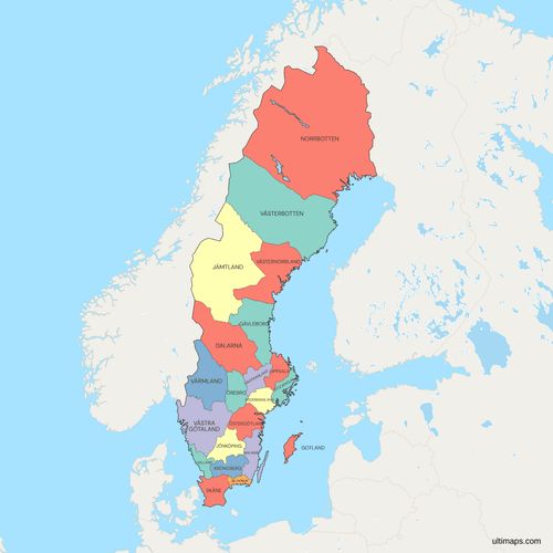 Political Map of Sweden with Countiespng1342 KB
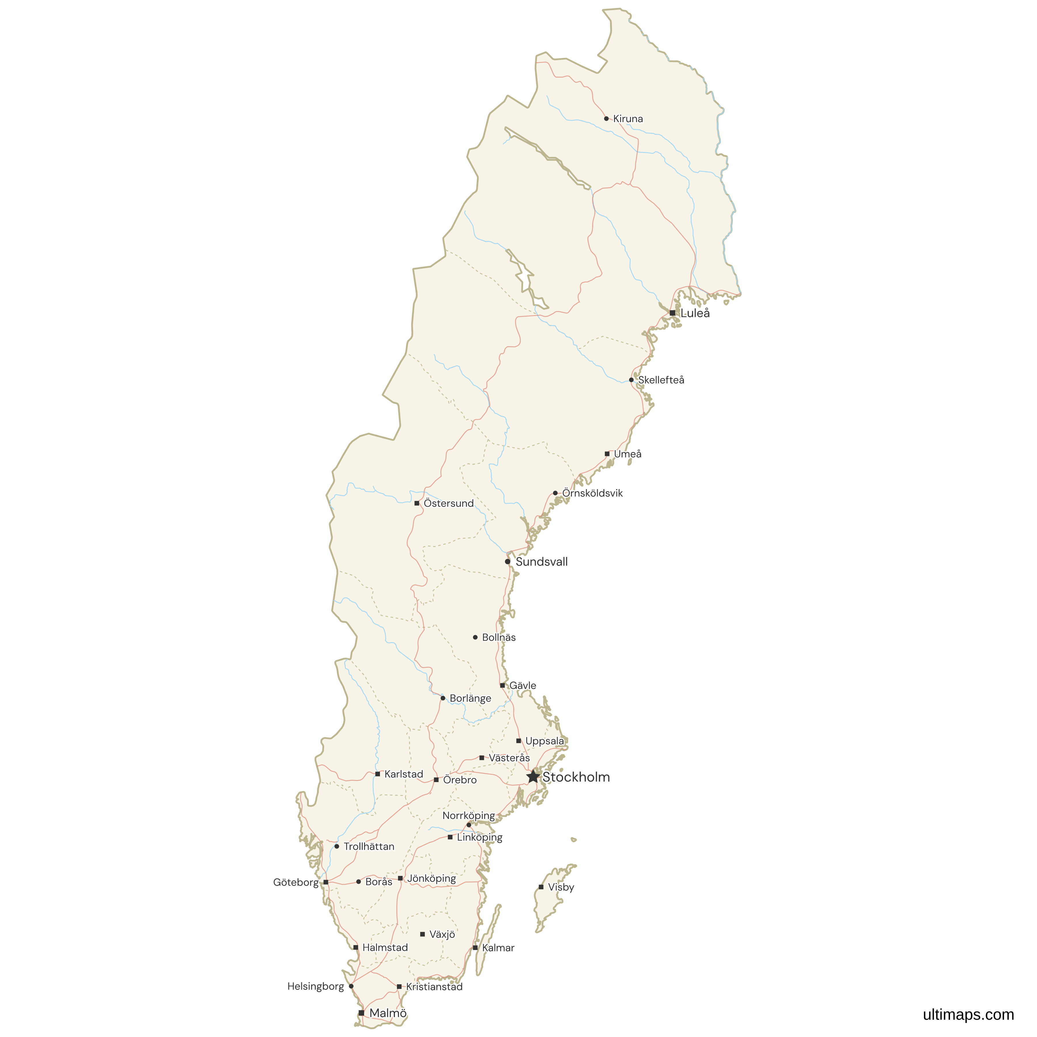
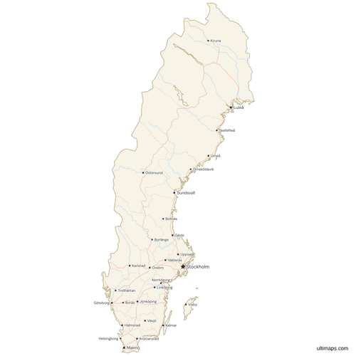 Map of Sweden with Cities and Roadspng665 KB
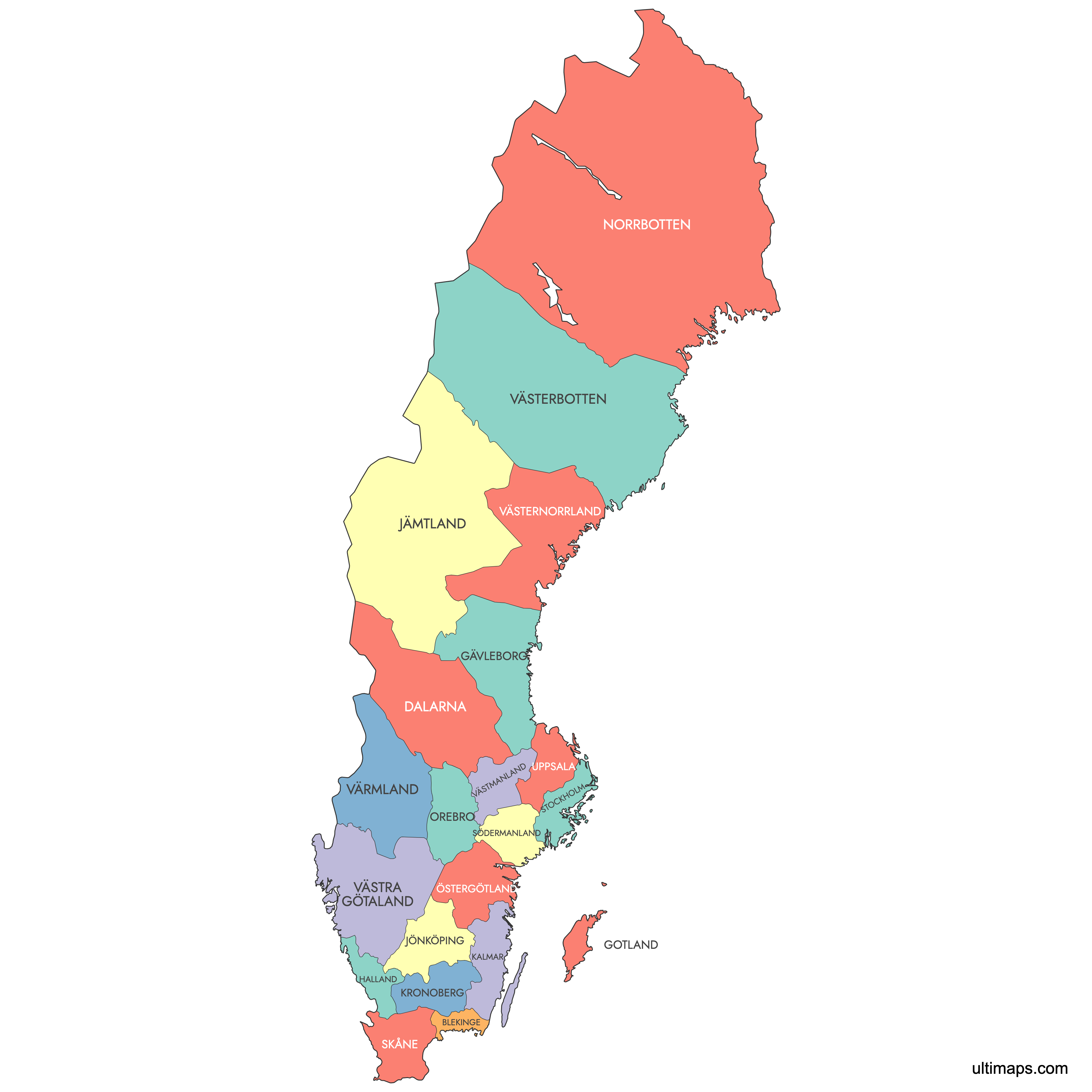
Need it without colors? The blank version of this map comes as a print-ready PDF (A4 and US Letter), a PNG and an editable SVG.
Custom Map Features
This map supports labels.
This map supports surrounding areas, roads, rivers and cities. New
This map is divided into 21 counties.
Updates
Jun 30, 2025:
- Added Map of Sweden Counties with labels
Frequently Asked Questions
Sweden has 21 counties, called län in Swedish, and this map shows all 21. The number dropped from 24 to 21 in two mergers. Skåne was formed on 1 January 1997 from Kristianstad and Malmöhus counties. Västra Götaland was formed on 1 January 1998 from Göteborg och Bohus, Älvsborg and most of Skaraborg. Populations range from more than 2.4 million in Stockholm County to about 61,000 on Gotland (SCB, 31 December 2024). Counties are divided into 290 municipalities (kommuner), which run local services such as schools and planning. Most county names come from the main city or from a historical province, as with Dalarna, Halland and Värmland.
Norrbotten is Sweden's largest county by area. According to Statistics Sweden, it covers more than 97,000 km² (about 37,500 sq mi) of land, nearly a quarter of Sweden's land area. It is the northernmost county and borders both Norway and Finland. Luleå is the county seat, and other towns include Kiruna, Piteå and Boden. Blekinge, on the southeast coast, is the smallest county by land area at about 2,930 km² (1,130 sq mi), with Karlskrona as its seat. Even with all that land, Norrbotten had fewer than 250,000 residents on 31 December 2024 (SCB), so most of the county is very sparsely populated.
Stockholm County is Sweden's most populated county. It had more than 2.4 million residents on 31 December 2024 according to Statistics Sweden (SCB), about 23 percent of the national total of 10.59 million. The county includes Stockholm, the national capital, and suburban municipalities such as Solna, Södertälje, Huddinge and Nacka. Västra Götaland, which includes Gothenburg, is second with more than 1.7 million residents. Skåne, which includes Malmö and Helsingborg, is third with more than 1.4 million (both SCB, 31 December 2024). Together these three counties hold more than half of Sweden's population. Gotland has the smallest population, about 61,000 (SCB, 31 December 2024).
In Sweden, a county (län) and a region (region) cover the same 21 areas but have different jobs. The county is the national government's level. Each one has a county administrative board (länsstyrelse), led by a governor (landshövding) whom the government appoints. The board handles supervision, environmental permits, hunting rules and civil defense planning. The region is an elected body with its own assembly and its own income tax. Regions run health care, public transport and regional development. All 20 county councils (landsting) had become regions by 1 January 2019. Gotland has no separate region. There, the municipality carries out the regional duties as Region Gotland.
Sweden's 21 counties are current administrative units. Its 25 provinces (landskap) are historical and cultural regions with no administrative role today. The provinces are still used for traditions, dialects, sports and symbols such as the provincial flowers and animals, and in everyday phrases such as "up in Norrland". The two sets of borders often differ. Småland, for example, is split mainly between Jönköping, Kronoberg and Kalmar counties. Lapland is divided between Norrbotten and Västerbotten. In the other direction, Västra Götaland county covers all of Bohuslän and Dalsland plus most of Västergötland. A few counties, such as Gotland, Halland and Blekinge, match their provinces almost exactly.
Gothenburg (Göteborg), Sweden's second-largest city, is in Västra Götaland County. That county had more than 1.7 million residents on 31 December 2024 (SCB) and also includes Borås, Trollhättan and Skövde. Malmö, the third-largest city, is in Skåne County at the southern tip of Sweden, along with Helsingborg, Lund and Kristianstad. The Øresund Bridge connects Malmö to Copenhagen. Uppsala, home to Uppsala Cathedral and Uppsala University (founded in 1477), is in Uppsala County, just north of Stockholm County. Other examples: Linköping and Norrköping are in Östergötland, Umeå is in Västerbotten, and Visby is on Gotland.
The most recent change to Sweden's county borders took effect on 1 January 2007. That day, Heby municipality moved from Västmanland County to Uppsala County, and this map shows the result. The larger reforms came about a decade earlier. On 1 January 1997, Kristianstad and Malmöhus counties merged to form Skåne. On 1 January 1998, Göteborg och Bohus, Älvsborg and most of Skaraborg merged to form Västra Götaland, and Habo and Mullsjö moved from Skaraborg to Jönköping County. These mergers reduced the count from 24 to 21. The county system itself goes back to the Instrument of Government of 1634.
The browser editor on this page turns the county map of Sweden into your own map, and it needs no account. To show territories or groupings, choose a color for each county one by one. To show statistics, give every county a value, such as population or income, and the counties are colored on a scale with a legend. Pins can mark places like Umeå, Gothenburg or Malmö, and the label style, border thickness, fonts and background are adjustable. Free exports are standard PNG images carrying a small Ultimaps credit, and Pro adds SVG, PDF and high-resolution PNG.