US regions map with the 4 Census Bureau regions
The Census Bureau groups the US into 4 regions: South (16 states and DC), West (13), Midwest (12) and Northeast (9). Alaska and Hawaii joined the West at the 1960 census. The table lists every state with its region. Download it as CSV, or embed the map free with credit.
by UltimapsLast updated
Remix opens a copy of this map, data included, for you to change. Free, no sign-up to start.
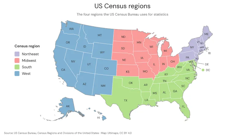
Source: US Census Bureau, Census Regions and Divisions of the United States (facts compiled by Ultimaps, CC BY 4.0)Data for
South17of 51 regions
West13of 51 regions
Midwest12of 51 regions
Northeast9of 51 regions
Data
| Region | Category | Note |
|---|---|---|
| Connecticut | Northeast | |
| Maine | Northeast | |
| Massachusetts | Northeast | |
| New Hampshire | Northeast | |
| New Jersey | Northeast | |
| New York | Northeast | |
| Pennsylvania | Northeast | |
| Rhode Island | Northeast | |
| Vermont | Northeast | |
| Illinois | Midwest | |
| Indiana | Midwest | |
| Iowa | Midwest | |
| Kansas | Midwest | |
| Michigan | Midwest | |
| Minnesota | Midwest | |
| Missouri | Midwest | |
| Nebraska | Midwest | |
| North Dakota | Midwest | |
| Ohio | Midwest | |
| South Dakota | Midwest | |
| Wisconsin | Midwest | |
| Alabama | South | |
| Arkansas | South | |
| Delaware | South | |
| District of Columbia | South | |
| Florida | South | |
| Georgia | South | |
| Kentucky | South | |
| Louisiana | South | |
| Maryland | South | |
| Mississippi | South | |
| North Carolina | South | |
| Oklahoma | South | |
| South Carolina | South | |
| Tennessee | South | |
| Texas | South | |
| Virginia | South | |
| West Virginia | South | |
| Alaska | West | Added to the West region (Pacific division) at the 1960 census |
| Arizona | West | |
| California | West | |
| Colorado | West | |
| Hawaii | West | Added to the West region (Pacific division) at the 1960 census |
| Idaho | West | |
| Montana | West | |
| Nevada | West | |
| New Mexico | West | |
| Oregon | West | |
| Utah | West | |
| Washington | West | |
| Wyoming | West |