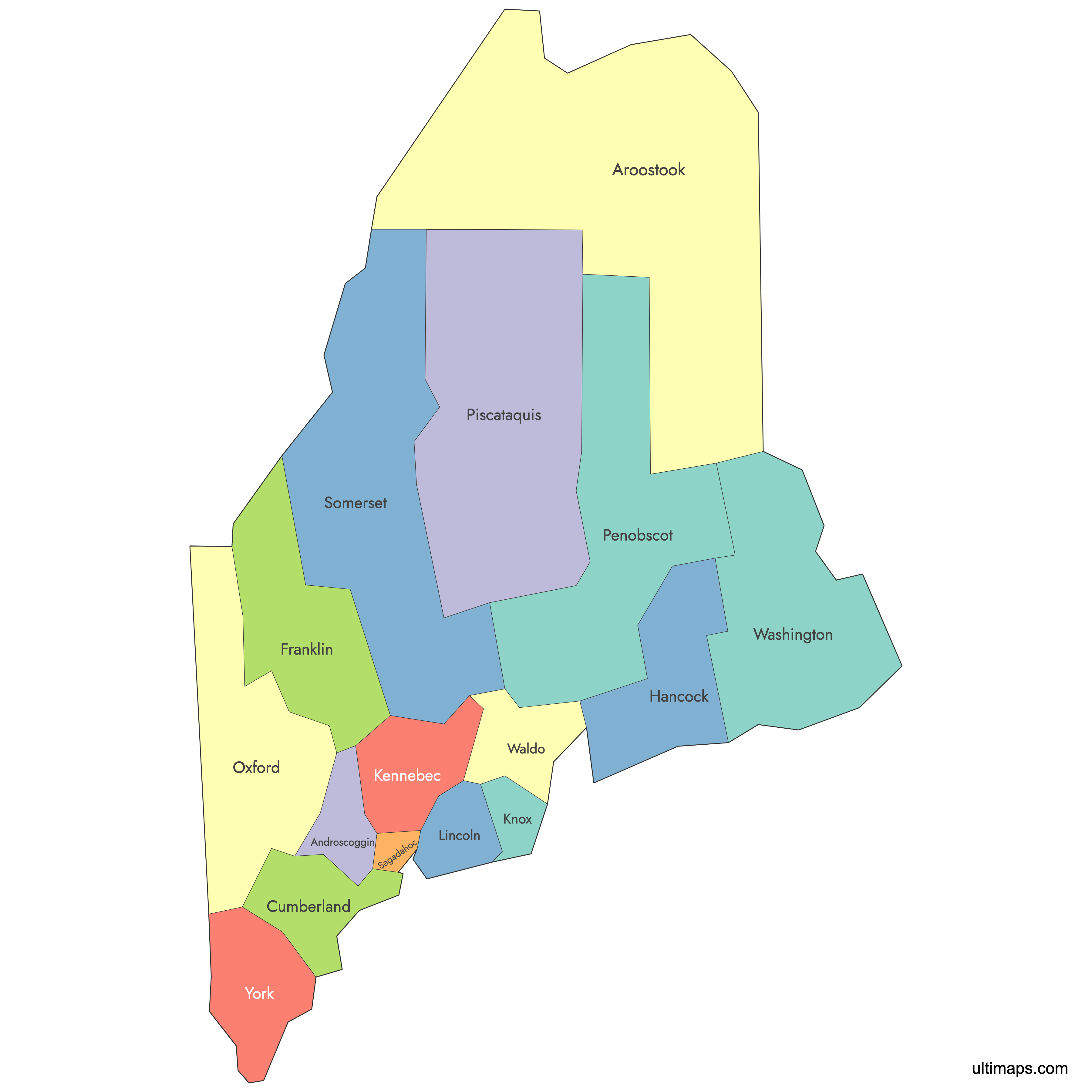
Map of Maine Counties
Maine is divided into 16 counties, a structure that has remained unchanged since 1860. The state stretches from the Atlantic coastline in the south and east to the Canadian border in the north, with counties ranging from densely populated Cumberland County to the vast wilderness of Aroostook County. Use the interactive maps below to explore county boundaries, download free reference maps, or create a custom map of Maine to visualize your own data.
Interactive Map of Maine Counties
List of Counties (16)
| # | County | County seat | Year founded |
|---|---|---|---|
| 1 | Auburn | 1854 | |
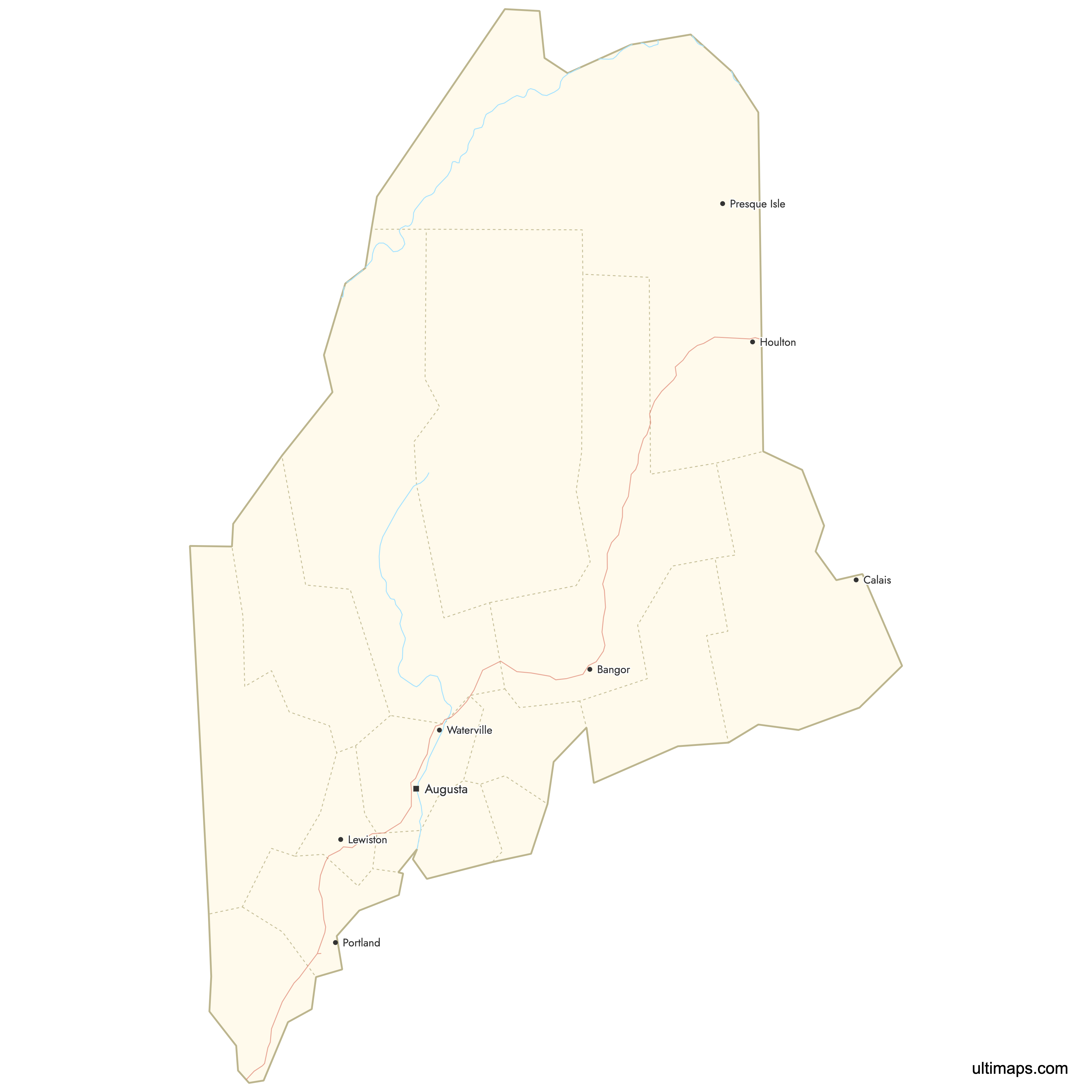
| 2 | Houlton | 1839 | |
| 3 | Portland | 1761 | |
| 4 | Farmington | 1838 | |
| 5 | Ellsworth | 1790 | |
| 6 | Augusta | 1799 | |
| 7 | Rockland | 1860 | |
| 8 | Wiscasset | 1760 | |
| 9 | Paris | 1805 | |
| 10 | Bangor | 1816 | |
| 11 | Dover-Foxcroft | 1838 | |
| 12 | Bath | 1854 | |
| 13 | Skowhegan | 1809 | |
| 14 | Belfast | 1827 | |
| 15 | Machias | 1790 | |
| 16 | Alfred | 1652 |
About Maine Counties: Key Facts
- Total number of counties: 16
- Most populous county: Cumberland County (Portland) at 317,222 people (2020 Census)
- Least populous county: Piscataquis County at 17,409 people (2020 Census)
- Largest county by area: Aroostook County at 6,829 square miles (17,687 km²)
- Smallest county by area: Sagadahoc County at 370 square miles (960 km²)
- State capital: Augusta, located in Kennebec County
- Borders: New Hampshire to the west, the Canadian provinces of Quebec to the northwest and New Brunswick to the northeast, and the Atlantic Ocean along the southern and eastern coast
- Time zone: Eastern Time Zone (UTC−5 / UTC−4 daylight saving)
- Current boundaries established: All 16 counties have been in place since 1860, when Knox County and Sagadahoc County were created
Interesting Facts
- Before achieving statehood in 1820, Maine was the "District of Maine" and part of Massachusetts. Its earliest counties were originally Massachusetts counties.
- Several county names have Native American origins. Aroostook derives from a Mi'kmaq word meaning "beautiful river," and Piscataquis comes from an Abenaki word meaning "rapid waters."
- Maine counties perform only limited governmental functions compared with most other U.S. states, primarily handling certain law enforcement roles, operating short-term jails, and maintaining roads in unincorporated areas.
- Aroostook County is the largest county east of the Mississippi River, covering more area than the states of Connecticut and Rhode Island combined.
- The 16-county structure has gone unchanged for over 160 years, an unusually long period without county reorganization compared with many other U.S. states.
Free Downloads
You can download free blank Map of Maine Counties and other maps in high resolution PNG, SVG and PDF formats from the blank maps section of the site: Download Blank Map of Maine Counties
Custom Map Features
This map supports labels.
This map is divided into 16 counties.
Updates
Aug 26, 2024:
- Added map of Maine Counties
Frequently Asked Questions
Maine has 16 counties. This county structure has been in place since 1860, when Knox County and Sagadahoc County were the last two counties created. Before statehood in 1820, Maine's counties were administered as part of Massachusetts.
Aroostook County is the largest county in Maine at 6,829 square miles (17,687 km²). It is the largest county east of the Mississippi River and borders both the Canadian provinces of Quebec and New Brunswick. The county seat is Houlton, and Presque Isle is its largest population center.
Sagadahoc County is the smallest county in Maine at 370 square miles (960 km²). It was established in 1854 and is located along the Atlantic coast. The town of Topsham is among its well-known communities.
Cumberland County is the most populous county in Maine with 317,222 residents according to the 2020 Census. It is home to Portland, Maine's largest city, as well as South Portland, Westbrook, Brunswick, Scarborough, and Falmouth. The least populous county is Piscataquis County with 17,409 people (2020 Census).
Acadia National Park is primarily in Hancock County on Mount Desert Island. Baxter State Park and Mount Katahdin, the northern terminus of the Appalachian Trail, are in Piscataquis County. Portland, Maine's largest city, is in Cumberland County, and the state capital Augusta is in Kennebec County. The Sugarloaf Mountain ski area and Rangeley Lakes region are both in Franklin County.
Maine borders New Hampshire to the west, the Canadian province of Quebec to the northwest, and the Canadian province of New Brunswick to the northeast. The Atlantic Ocean, including the Gulf of Maine, forms the southern and eastern boundary. Seven counties share a border with Canada, including Aroostook, Somerset, Franklin, Oxford, Piscataquis, Penobscot, and Washington.
You can use Ultimaps to create custom maps of Maine. Color-code counties manually or upload your data, place pins, customize the look, and export to PNG, PDF, or SVG. No sign-up required.