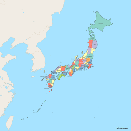
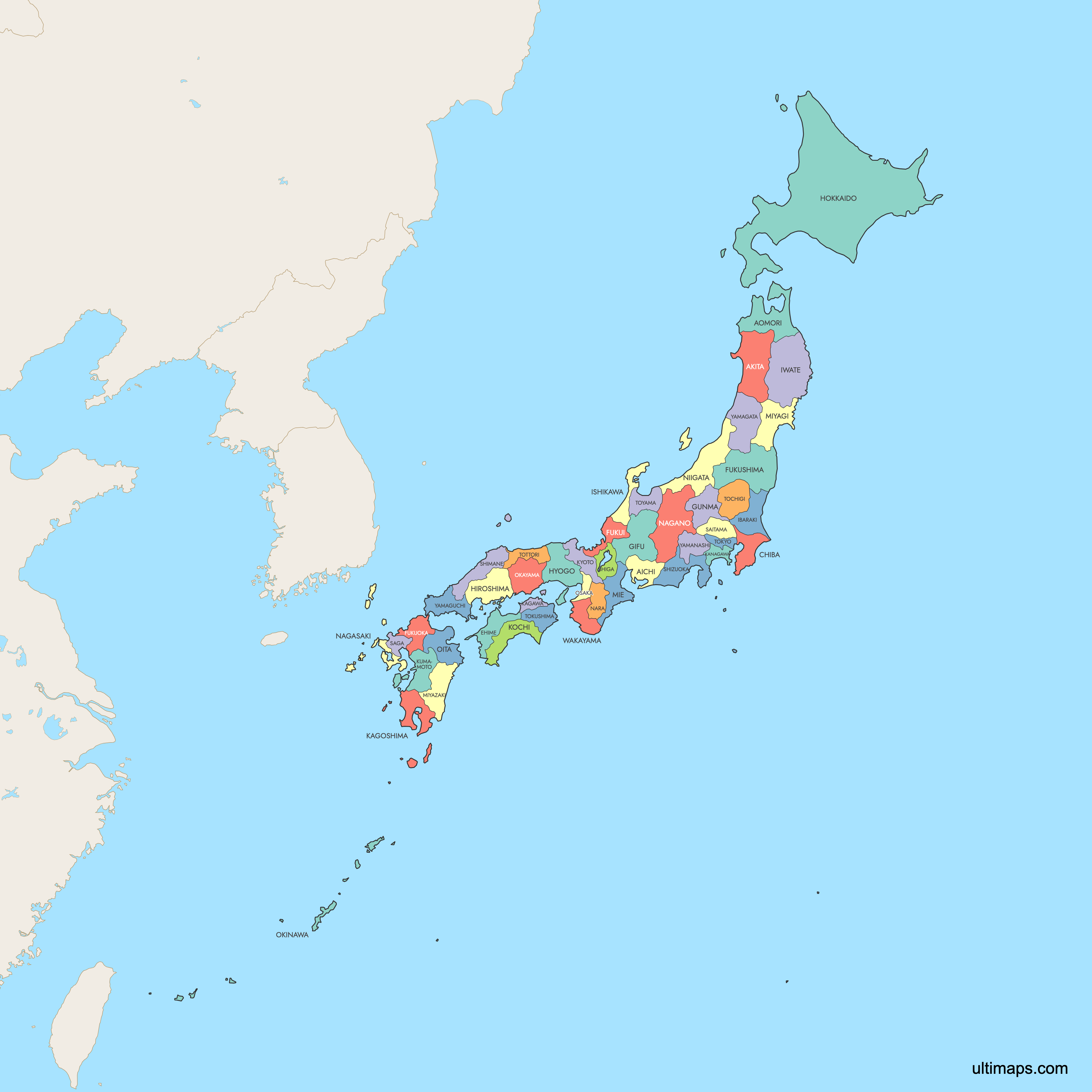
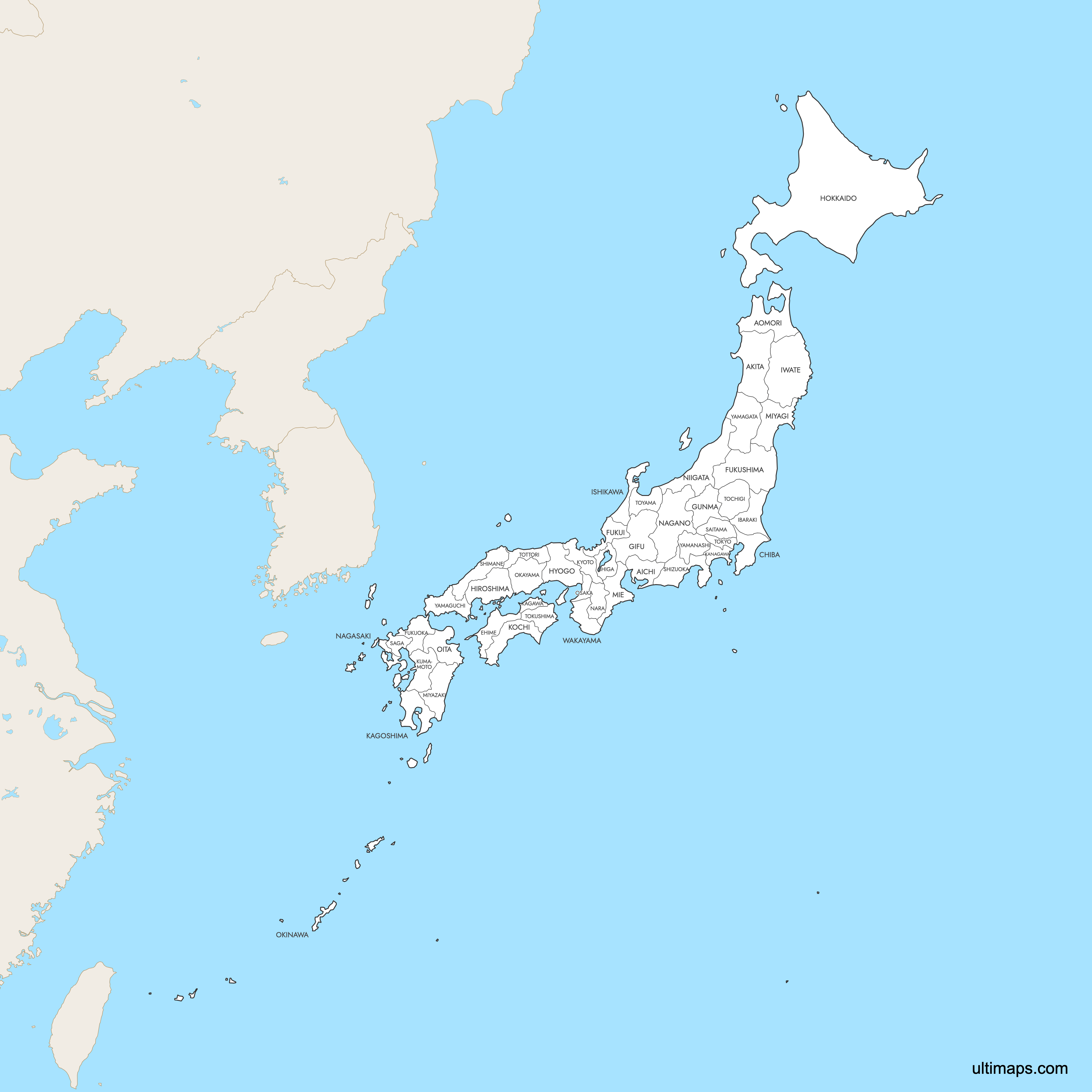
Map of Japan Prefectures
Japan is divided into 47 prefectures, including 43 ordinary prefectures, two urban prefectures (Osaka and Kyoto), one regional prefecture (Hokkaidō), and one metropolis (Tokyo). These administrative divisions span four main islands and stretch from subarctic Hokkaidō in the north to subtropical Okinawa in the south. Use the interactive maps below to explore all 47 prefectures and their boundaries. Download free maps or learn more about creating a custom map of Japan to visualize your own data.
Interactive Map of Japan Prefectures
List of Prefectures (47)
| # | Prefecture |
|---|---|
| 1 | |
| 2 | |
| 3 | |
| 4 | |
| 5 | |
| 6 | |
| 7 | |
| 8 | |
| 9 | |
| 10 | |
| 11 | |
| 12 | |
| 13 | |
| 14 | |
| 15 | |
| 16 | |
| 17 | |
| 18 | |
| 19 | |
| 20 | |
| 21 | |
| 22 | |
| 23 | |
| 24 | |
| 25 | |
| 26 | |
| 27 | |
| 28 | |
| 29 | |
| 30 | |
| 31 | |
| 32 | |
| 33 | |
| 34 | |
| 35 | |
| 36 | |
| 37 | |
| 38 | |
| 39 | |
| 40 | |
| 41 | |
| 42 | |
| 43 | |
| 44 | |
| 45 | |
| 46 | |
| 47 |
Japan Prefectures: Key Facts
- Total number of prefectures: 47, grouped into eight informal regions: Hokkaidō, Tōhoku, Kantō, Chūbu, Kansai, Chūgoku, Shikoku, and Kyūshū-Okinawa
- Most populous prefecture: Tokyo with 14,047,594 residents (2020 Census)
- Least populous prefecture: Tottori Prefecture with 553,407 residents (2020 Census)
- Largest prefecture by area: Hokkaidō at 83,520 km² (32,247 sq mi)
- Smallest prefecture by area: Kagawa Prefecture at 1,862 km² (719 sq mi)
- Major urban centers: Tokyo (Tokyo Metropolis), Osaka (Osaka Prefecture), Nagoya (Aichi Prefecture), Yokohama (Kanagawa Prefecture), Sapporo (Hokkaidō), Kobe (Hyōgo Prefecture), Kyoto (Kyoto Prefecture), and Fukuoka (Fukuoka Prefecture)
- Capital: Tokyo Metropolis
- Surrounding bodies of water: Pacific Ocean (east and south), Sea of Japan (west), Sea of Okhotsk (northeast), East China Sea (southwest), and Korea Strait (southwest). Japan shares no land borders with other countries.
- Time zone: Japan Standard Time (UTC+9) across all prefectures, with no daylight saving time
- Boundary history: The current 47 prefectures were formed through mergers and consolidations starting in 1871, when feudal domains (han) were replaced during the Meiji Restoration. Boundaries have remained stable since the early 20th century.
Interesting Facts
- Tokyo holds a unique status as a "merged city-prefecture," combining both urban municipal and prefectural government functions into a single administrative unit.
- Okinawa Prefecture, Japan's southernmost, was annexed from the independent Ryukyu Kingdom in 1879 and retains a distinct Ryukyuan culture and subtropical climate.
- Hokkaidō was developed as a frontier region later than the rest of Japan and has deep roots in Ainu indigenous history, with Shiretoko National Park now a UNESCO World Heritage wilderness site.
- Mount Fuji, Japan's iconic volcano and UNESCO World Heritage site, straddles the border of two prefectures: Yamanashi and Shizuoka.
- The eight regional groupings of prefectures (such as Kantō and Kansai) have no formal government authority and are used primarily for statistical, cultural, and geographic reference.
Free Downloads
 Colored Map of Japan Prefectures with Surrounding Areaspng732 KB
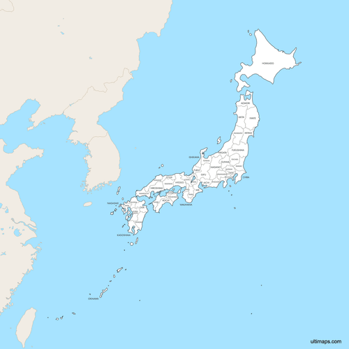 Labeled Map of Japan Prefectures with Surrounding Areaspng727 KB
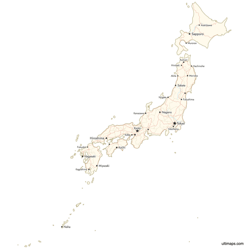 Map of Japan Prefectures with Citiespng671 KB

You can download free blank Map of Japan Prefectures and other maps in high resolution PNG, SVG and PDF formats from the blank maps section of the site: Download Blank Map of Japan Prefectures
Custom Map Features
This map supports labels.
This map supports surrounding areas, roads, rivers and cities. New
This map is divided into 47 prefectures.
Updates
Apr 23, 2026:
- Added map of Japan prefectures with surrounding countries, cities and roads
Frequently Asked Questions
Japan has 47 prefectures. These consist of 43 ordinary prefectures (ken), two urban prefectures (fu) for Osaka and Kyoto, one regional prefecture (dō) for Hokkaidō, and one metropolis (to) for Tokyo. The prefectures are informally grouped into eight regions: Hokkaidō, Tōhoku, Kantō, Chūbu, Kansai, Chūgoku, Shikoku, and Kyūshū-Okinawa.
Hokkaidō is the largest prefecture by area at 83,520 km² (32,247 sq mi). It occupies Japan's entire northernmost main island and is known for its wilderness, including the UNESCO-listed Shiretoko National Park. Its capital city is Sapporo.
Kagawa Prefecture is the smallest by area at 1,862 km² (719 sq mi). It is located on the island of Shikoku, facing the Seto Inland Sea. Despite its small size, Kagawa is known for its udon noodles and the historic Ritsurin Garden.
Tokyo is the most populated prefecture with 14,047,594 residents according to the 2020 Census. It serves as Japan's capital and functions as a unique merged city-prefecture (metropolis). The least populated prefecture is Tottori with 553,407 residents (2020 Census).
Mount Fuji, a UNESCO World Heritage site, sits on the border of Yamanashi and Shizuoka Prefectures. The Hiroshima Peace Memorial, another UNESCO site, is in Hiroshima Prefecture. Kyoto Prefecture is home to historic temples like Kinkaku-ji and the Kyoto Imperial Palace, while Osaka Prefecture features the iconic Osaka Castle.
Japan's prefectures were created starting in 1871 during the Meiji Restoration, when feudal domains (han) were abolished and converted into prefectures. Through a series of mergers and consolidations, the current 47 prefectures were finalized by the early 20th century. Boundaries have remained stable since then with only minor adjustments.
Japan's 47 prefectures are informally grouped into eight regions: Hokkaidō (1 prefecture), Tōhoku (6), Kantō (7), Chūbu (9), Kansai (7), Chūgoku (5), Shikoku (4), and Kyūshū-Okinawa (8). These regions have no formal government and are used for statistical, cultural, and geographic grouping purposes.
Japan is an island nation with no land borders. It is surrounded by the Pacific Ocean to the east and south, the Sea of Japan to the west, the Sea of Okhotsk to the northeast, the East China Sea to the southwest, and the Korea Strait to the southwest. All 47 prefectures operate on Japan Standard Time (UTC+9) with no daylight saving time.
You can use Ultimaps to create custom maps of Japan. Color-code prefectures manually or upload your data, place pins, customize the look and feel, and export to PNG, PDF, or SVG. No sign-up required.