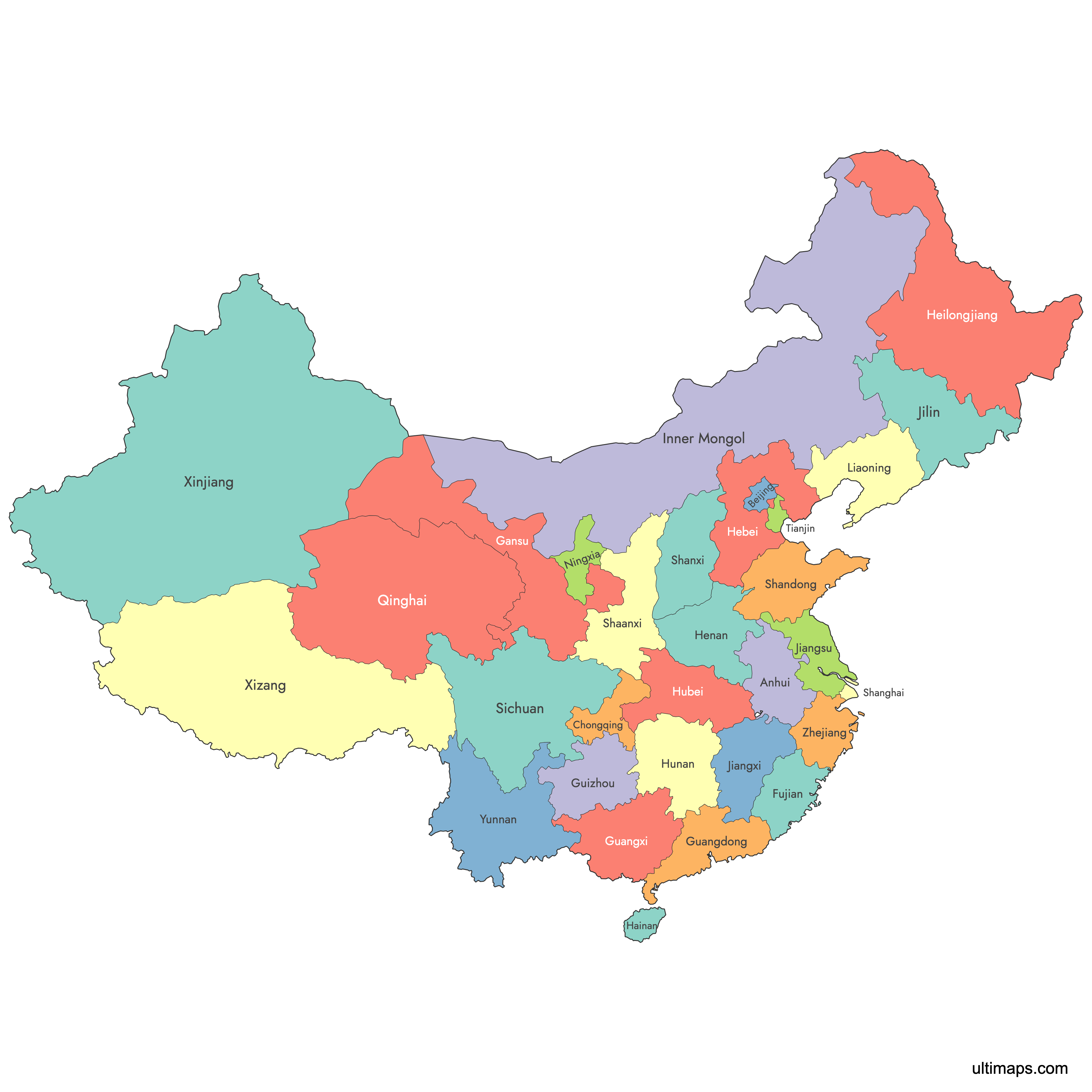
Map of China Provinces
China is divided into 34 province-level divisions: 22 provinces, 5 autonomous regions, 4 municipalities, 2 special administrative regions, and Taiwan (claimed but not administered). Use the interactive maps below to explore boundaries, provincial capitals, and major cities across the country. Download free reference maps or learn more about creating a custom map of China to visualize your own data.
Interactive Map of China Provinces
List of Regions (32)
| # | Region |
|---|---|
| 1 | |
| 2 | |
| 3 | |
| 4 | |
| 5 | |
| 6 | |
| 7 | |
| 8 | |
| 9 | |
| 10 | |
| 11 | |
| 12 | |
| 13 | |
| 14 | |
| 15 | |
| 16 | |
| 17 | |
| 18 | |
| 19 | |
| 20 | |
| 21 | |
| 22 | |
| 23 | |
| 24 | |
| 25 | |
| 26 | |
| 27 | |
| 28 | |
| 29 | |
| 30 | |
| 31 | |
| 32 |
About China's Provinces
- Province-level divisions: 34 total, comprising 22 provinces (plus Taiwan, claimed but not controlled), 5 autonomous regions, 4 direct-controlled municipalities, and 2 special administrative regions (Hong Kong and Macao).
- Largest division by area: Xinjiang Uyghur Autonomous Region, approximately 1,664,900 km² (642,820 sq mi).
- Smallest province by area: Hainan Province, approximately 33,920 km² (13,100 sq mi).
- Most populous province: Guangdong Province, with over 126 million residents.
- Least populous province: Qinghai Province, with approximately 6 million residents.
- National capital: Beijing, a direct-controlled municipality at the same administrative rank as a province.
- Land borders (14 countries): Afghanistan, Bhutan, India, Kazakhstan, Kyrgyzstan, Laos, Mongolia, Myanmar, Nepal, North Korea, Pakistan, Russia, Tajikistan, and Vietnam.
- Major seas: Yellow Sea, East China Sea, and South China Sea.
- Time zone: China Standard Time (UTC+8) across the entire country, despite spanning roughly five geographical time zones.
- Last major boundary changes: Hainan Province was separated from Guangdong in 1988; Chongqing was split from Sichuan and elevated to a municipality in 1997.
Interesting Facts
- All of China officially operates on a single time zone (UTC+8), even though the country stretches roughly 5,200 km from east to west. Residents in far-western Xinjiang sometimes follow an unofficial local time two hours behind Beijing.
- Henan Province is often called the "cradle of Chinese civilization," home to some of the earliest farming settlements and ancient temples in the country.
- Hainan, China's smallest province, is a tropical island sometimes nicknamed "China's Hawaii" for its beaches and warm climate.
- Shandong Province is the birthplace of Confucius and is also famous for Qingdao, the coastal city known worldwide for its beer and seafood.
- Beijing, Shanghai, Tianjin, and Chongqing hold the special status of direct-controlled municipalities, functioning as province-level "super cities" that report directly to the central government.
Free Downloads
You can download free blank Map of China Provinces and other maps in high resolution PNG, SVG and PDF formats from the blank maps section of the site: Download Blank Map of China Provinces
Custom Map Features
This map supports labels.
This map is divided into 32 regions.
Updates
Nov 21, 2024:
- Added map of China provinces
Frequently Asked Questions
China has 34 province-level divisions. These include 22 provinces administered by the PRC (plus Taiwan, which is claimed but not controlled), 5 autonomous regions, 4 direct-controlled municipalities (Beijing, Shanghai, Tianjin, and Chongqing), and 2 special administrative regions (Hong Kong and Macao). All 34 divisions hold the same administrative rank.
Xinjiang Uyghur Autonomous Region is the largest, covering approximately 1,664,900 km² (642,820 sq mi). Located in China's far northwest, it borders eight countries and features vast deserts, mountain ranges, and a strong Uyghur cultural presence.
Hainan Province is the smallest province by area, at roughly 33,920 km² (13,100 sq mi). It is a tropical island off the southern coast, often nicknamed "China's Hawaii" for its beaches and warm climate. Its capital is Haikou.
Guangdong Province is the most populous, with over 126 million residents. Its capital, Guangzhou, and the tech hub of Shenzhen anchor the Pearl River Delta, one of the most urbanized and economically productive regions in the world.
Beijing, the national capital, is a direct-controlled municipality home to the Forbidden City and Tiananmen Square. Chengdu in Sichuan Province is famous for giant pandas and spicy cuisine. Lhasa in the Tibet Autonomous Region is known for its high-altitude Buddhist monasteries, while Suzhou in Jiangsu Province is celebrated for its historic canals and classical gardens.
China shares land borders with 14 countries: Afghanistan, Bhutan, India, Kazakhstan, Kyrgyzstan, Laos, Mongolia, Myanmar, Nepal, North Korea, Pakistan, Russia, Tajikistan, and Vietnam. Its eastern and southern coastline meets the Yellow Sea, the East China Sea, and the South China Sea.
You can use Ultimaps to create custom maps of China. Color-code regions manually or upload your data, place pins, customize the look, and export to PNG, PDF, or SVG. No sign-up required.