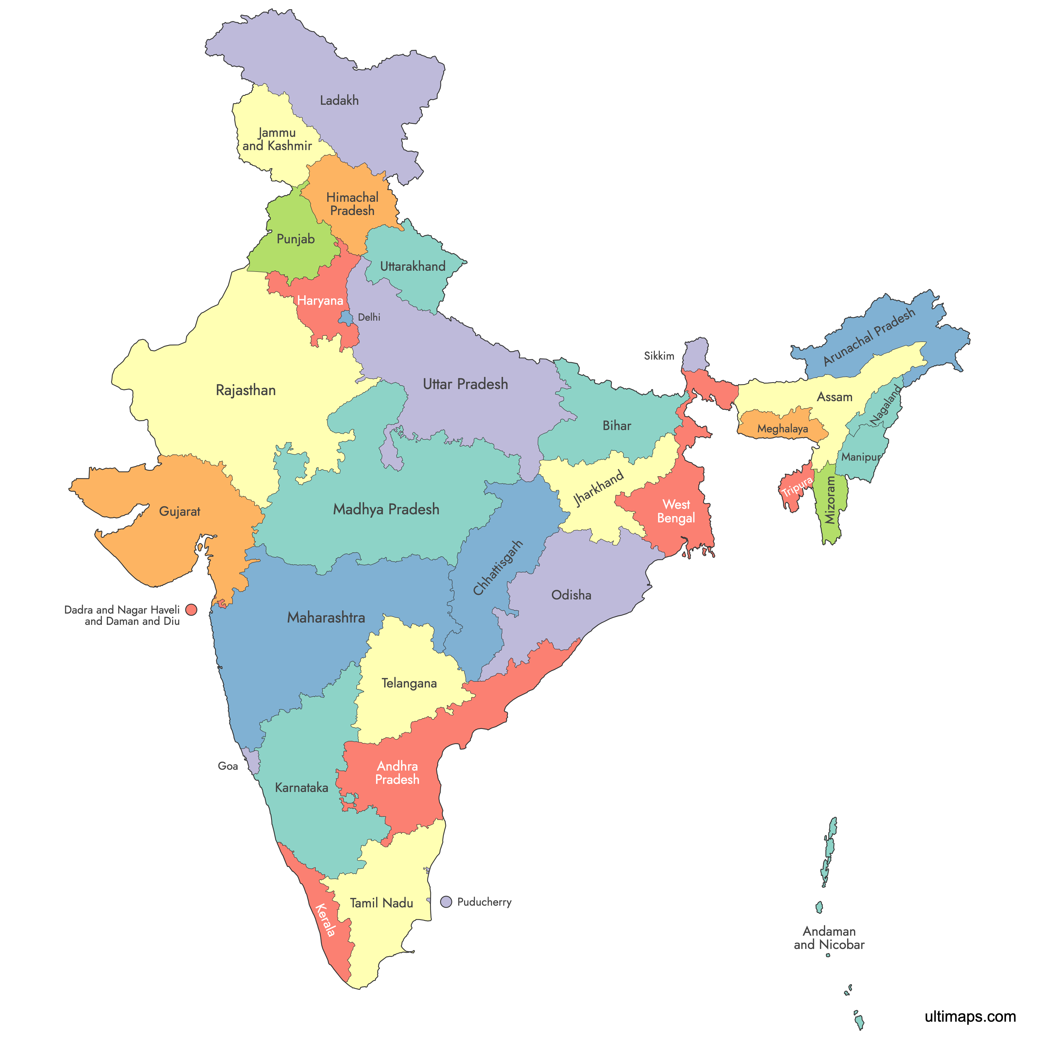
Map of India
India is divided into 28 states and 8 union territories, totaling 36 first-order administrative units stretching from the Himalayas to the Indian Ocean. Use the interactive map below to explore state boundaries, capitals, and major cities. Download free reference maps or learn more about creating a custom map of India to visualize your own data.
Interactive Map of India
List of States (36)
| # | State |
|---|---|
| 1 | |
| 2 | |
| 3 | |
| 4 | |
| 5 | |
| 6 | |
| 7 | |
| 8 | |
| 9 | |
| 10 | |
| 11 | |
| 12 | |
| 13 | |
| 14 | |
| 15 | |
| 16 | |
| 17 | |
| 18 | |
| 19 | |
| 20 | |
| 21 | |
| 22 | |
| 23 | |
| 24 | |
| 25 | |
| 26 | |
| 27 | |
| 28 | |
| 29 | |
| 30 | |
| 31 | |
| 32 | |
| 33 | |
| 34 | |
| 35 | |
| 36 |
About India
India is a country in South Asia, known for its diverse regions and populations. It is divided into states and union territories, each with its own administrative boundaries. The internal boundaries help differentiate each region’s unique governing structures, cultures, and significance.
Key facts about the India map:
- Number of states: 28
- Number of union territories: 8
- Total regions: 36
- Largest state by area: Rajasthan
- Most populous state: Uttar Pradesh
- Smallest state by area: Goa
- Major urban centers: Delhi, Mumbai, Bengaluru, Kolkata, Chennai, Hyderabad
- Prominent boundaries: Shares borders with Pakistan, China, Nepal, Bhutan, Bangladesh, and Myanmar, plus the Indian Ocean coast
- Political boundaries have evolved over time, with the most recent state formations in the 21st century
Free Downloads
You can download free blank Map of India and other maps in high resolution PNG, SVG and PDF formats from the blank maps section of the site: Download Blank Map of India
Custom Map Features
This map supports labels.
This map is divided into 36 states.
Updates
Sep 26, 2024:
- Added map of India
Frequently Asked Questions
India has 28 states and 8 union territories, for a total of 36 first-order administrative units. The most recent changes took effect on 31 October 2019, when Jammu and Kashmir was reorganized into two union territories (Jammu and Kashmir, and Ladakh), and on 26 January 2020, when Dadra and Nagar Haveli and Daman and Diu merged into a single union territory. This 28+8 structure has remained unchanged since 2020.
Rajasthan is the largest state by area at 342,239 km² (132,139 sq mi). Among union territories, Ladakh is the largest at 152,096 km² (59,146 sq mi). The smallest state by area is Goa at 3,702 km² (1,429 sq mi).
Goa is the smallest state by area at 3,702 km² (1,429 sq mi). Among union territories, Lakshadweep is the smallest at just 32 km² (12 sq mi). Lakshadweep is also the least populous administrative unit in India, with a 2011 Census population of 64,473.
Uttar Pradesh is the most populous state, with 199,812,341 people recorded in the 2011 Census. Its capital is Lucknow. Among union territories, Delhi (NCT) is the most populous at 16,787,941 (2011 Census), while the least populous state is Sikkim at 610,577.
The Taj Mahal is in Agra, Uttar Pradesh. The Red Fort and India Gate are in Delhi (NCT), the national capital territory. The Gateway of India is in Mumbai, the capital of Maharashtra and India's largest city. Other major cities include Bengaluru (Karnataka), Chennai (Tamil Nadu), Kolkata (West Bengal), and Hyderabad (Telangana).
India shares land borders with six countries: Pakistan to the west, China and Nepal to the north, Bhutan to the northeast, and Bangladesh and Myanmar to the east. It is bounded by the Arabian Sea to the southwest, the Bay of Bengal to the southeast, and the Indian Ocean to the south. The Andaman and Nicobar Islands extend India's maritime presence into the Andaman Sea.
You can use Ultimaps to create custom maps of India. Color-code states manually or upload your data, place pins, customize the look, and export to PNG, PDF, or SVG. No sign-up required.