Ultimaps vs Datawrapper for maps
Choose Datawrapper if
you publish charts and maps for a newsroom or a team, or need one of its 4,749 basemaps or your own uploaded boundaries. Its free plan publishes unlimited maps, and Pro costs US$21 per user a month, billed annually.
Choose Ultimaps if
you make maps rather than charts and want popups, click-through links and hand coloring next to your data, a map from a pasted table, with the color scale and legend built for you and every detail editable after, or maps straight from ChatGPT or Claude. You can also buy one clean SVG or high-resolution PNG without a subscription: a one-map pass costs €12.50 and lasts 24 hours.
Compared on by the Ultimaps team. Sources below.
Try Ultimaps freeWhen Ultimaps fits better than Datawrapper
One clean map, no subscription
Datawrapper's free plan exports PNG with its credit. SVG, PDF and files without the credit need Pro, at US$21 per user a month, billed annually. Ultimaps sells a 24-hour pass for one map at €12.50, with a clean high-resolution PNG, SVG and PDF.
Popup templates and click-through links
Datawrapper's published maps have tooltips that stick on click, zoom buttons and a legend that highlights on hover. Ultimaps maps add popups on click and click-through links to other pages, written as templates with your data columns and overridable for any single region or pin.
Labels where you put them
Datawrapper labels regions from a data column and lets you add places. A place label takes new text and one of four corner spots, labels that do not fit are left out, and only text annotations can be dragged. In Ultimaps you drag any label where you want it, rename it with a double-click, and resize or rotate it. A label moved completely outside its region gets a leader line. Crowded labels are listed for you to fix instead of hidden.
Bring an existing map with you
Upload a screenshot or a photo of a printed map and AI reads its legend, region colors and labelled pins into an editable map, which you review before it is applied. Free accounts get 20 AI requests a month.
Maps from ChatGPT or Claude
Ultimaps builds and runs its own MCP server. It is in ChatGPT's app directory, and you add it to Claude by URL, with no account or key needed to start. Datawrapper has no MCP server of its own, and its developer docs do not mention one. A community MCP server built on its API exists, and it needs your own Datawrapper API token.
Ultimaps vs Datawrapper, feature by feature
Swipe the table sideways to see every column.
| Feature | Ultimaps | Datawrapper |
|---|---|---|
| Better on Ultimaps | ||
| SVG: One map without a subscription | Partly. Vector SVG with the title, legend and labels kept. €12.50 for one map, or Pro | Partly. Pro and up[1] |
| Interactive maps: Popups and click-through links | Yes. Tooltips, popups, click-through links, zoom and an interactive legend | Yes. Tooltips that stick on click, zoom buttons, legend hover highlight[2] |
| Region labels | Yes. Names, values or both. Drag, rename, resize or rotate any label right on the map. Crowded labels are listed for you to fix instead of hidden | Partly. From a data column or places you add. A place label takes new text and one of four corner spots. Labels that do not fit are left out[3] |
| Maps from ChatGPT and Claude | Yes. Our own MCP server, free. In ChatGPT's app directory, added to Claude by URL, no account or key to start | No. Only a community server built on its API, which needs your Datawrapper API token[4] |
| Both do it | ||
| Free plan | Yes. Unlimited maps saved to a free account, interactive maps with popups, publish and embed, PNG export | Yes. Unlimited charts, maps and embeds and PNG export, with its credit. Team workspace[1] |
| Works without an account | Yes. You can build and export without one. A free account saves and publishes | Yes. You can build without one. Sign up to publish[5] |
| Data import | Yes. CSV, TSV, Excel, Google Sheets, Notion or paste. AI from a prompt or a picture of a map | Yes. CSV or Excel upload, paste, Google Sheets, a live external link[2] |
| Matching rows to regions | Yes. Automatic, by region name or code | Yes. Automatic, by name or ID (FIPS, ISO). Unmatched rows flagged[2] |
| Color scale from numbers | Yes. Suggested from the data. Gradient, steps or groups. Equal interval, quantile, Jenks, pretty or custom | Yes. Gradient or steps: linear, quantile, rounded, Jenks or custom[6] |
| US counties | Yes. All ~3,100 in one map, plus a county map for every state | Yes. Several census vintages[7] |
| US ZIP codes | Yes. ZIP (Census ZCTA) maps for every state, DC, Puerto Rico, Guam and the US Virgin Islands, plus a national 3-digit map. No nationwide 5-digit map | Yes. ZIP/ZCTA maps per state and a national 3-digit map. No nationwide 5-digit map[7] |
| Pins | Yes. From addresses (geocoded), coordinates or a file | Yes. Locator and symbol maps with markers[8] |
| Text and arrows on the map | Yes. Free text, rectangles, lines with arrowheads and callouts tied to regions, anywhere on the canvas | Yes. Text annotations with lines, arrows and circles, on choropleth and symbol maps[9] |
| Embed on a website | Yes. Iframe, and share links that turn into live maps in Notion, WordPress, Ghost and Substack. Free with a small "made with ultimaps.com" credit | Yes. Responsive embed, iframe and a WordPress oEmbed plugin, all free, with the Datawrapper credit[10] |
| Free exports | Partly. PNG at screen resolution, sharp for web pages and slides, with a small "made with ultimaps.com" credit. Print-size PNG (6×) with Pro or a one-map pass | Partly. PNG with the "Created with Datawrapper" credit[1] |
| PDF: Ultimaps PDFs hold an image of the map | Partly. High-resolution PDF (an image of the map, not vector), on Pro or the one-map pass | Partly. Pro and up[1] |
| Credit on free maps | "made with ultimaps.com" on free PNGs and embeds. None on Pro or a one-map pass export | "Created with Datawrapper" on free charts and maps[1] |
| Paid plans | €12.50 ($14.90) for one map (24-hour pass), or Pro €49/month or €499/year | Pro: US$21 per user a month, billed annually[1] |
| Where Datawrapper goes further | ||
| Maps | Yes. 250+ base maps, checked by hand and kept current: world, continents, most countries by state or province, every US state by county and by ZIP code | Yes. 4,749 basemaps[7] |
| Your own boundaries | No. You cannot upload them. Custom maps made to order, from €49 per map with no subscription | Yes. Upload TopoJSON or GeoJSON under 2 MB[11] |
Not stated means the tool’s own pages do not say, or we could not confirm it. Numbers in brackets link to the source.
Pricing: Ultimaps vs Datawrapper
Both have a free plan that publishes and embeds maps with a credit. Datawrapper charges per user, billed annually by default. Ultimaps Pro covers one user, monthly or yearly, or you pay once for a single map. Teams that need brand themes with their own fonts get them built by our team on the Ultimaps Custom plan.
| Datawrapper plan | Price |
|---|---|
| Free | US$0, unlimited charts, maps and embeds, PNG export[1] |
| Pro: Adds PDF and SVG export and removes the credit. Excludes VAT. | US$21 per user a month, billed annually[1] |
| Business: Excludes VAT. | US$39 per user a month, billed annually[1] |
| Enterprise | Contact sales[1] |
Ultimaps plans
Free
€0
Free forever
Make maps from your data and share them. No card, and no sign-up until you save or publish.
No sign-up or card needed
What’s included
- Unlimited maps
- Import Excel, CSV, Sheets or Notion
- 100 address lookups + 20 AI requests a month
- PNG export with credit
- Commercial use with the credit
- Interactive maps you can embed
Pro
: Save 15%Billed monthly: €49. Billed yearly: €41.58/month
Billed €499 yearly
For professionals who publish maps often. Pays for itself from about 4 maps a month.
Cancel anytime
Everything in Free, plus
- Unlimited exports, no credit
- 6× resolution PNG, plus SVG and PDF
- Unbranded interactive maps
- Templates and duplicates
- 5,000 lookups + 500 AI requests a month
- Priority email support
Custom
Custom
Tailored to your needs
For organizations that need maps in their own brand, a map we don't have or custom map behavior.
Custom maps from €49 per map
Everything in Pro, plus
- Custom maps for any region
- Custom themes and fonts
- Invite users to your workspace
- Custom interactive logic
Just one map? €12.50 per map
High-res PNG, SVG and PDF with no credit. The files are yours to use commercially, forever, and you can re-export that map for 24 hours.
Exporting 4 or more maps a month? Pro costs less.
No card for Free · Cancel anytime, Pro runs to the end of your paid period · 30% off for non-profits

The same data in both tools
One table, two tools: the 2025 unemployment rate in all 50 states and DC, from the Bureau of Labor Statistics. Download the CSV and try both yourself.
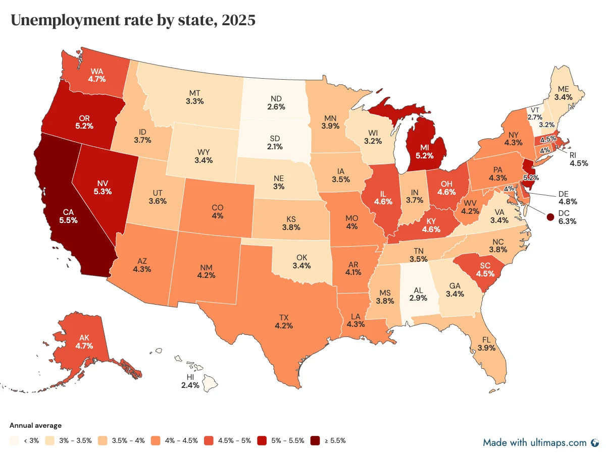
In Ultimaps
- Open Studio, start a United States map and open Import Data.
- Paste the two columns (state and rate) or upload the CSV. All 51 rows match by state name.
- Ultimaps suggests a stepped color scale with round class edges and builds the legend. Switch to quantile, Jenks or custom breaks if you like.
- Add a tooltip or popup template that shows the rate, then publish the map and embed it.
In Datawrapper
- Start a choropleth map and pick a US states basemap.
- Paste or upload the table. Datawrapper matches state names or codes to the basemap and flags rows it cannot match.
- Choose a gradient or steps, and a step type such as quantile or natural breaks (Jenks).
- Publish to get the embed code, or download a PNG. SVG and PDF need Pro.
Datawrapper’s own guide: How to create a choropleth map
Switching from Datawrapper
Your Datawrapper data moves as it is: Ultimaps reads the same spreadsheet.
- Open the spreadsheet you used in Datawrapper.
- In Ultimaps Studio, start the matching base map (US states, US counties, a state's ZIP codes, a country) and import the file or paste the table.
- Pick the column that colors the map. The other columns stay available for tooltips and popups.
- To match a chart you already published, set the palette and breaks by hand, or upload a screenshot of it with Upload Image.
Where Datawrapper is still ahead
- Thousands of basemaps (4,749 entries across 285 countries and regional sets, many in several versions), including US census vintages and many election-district and municipal maps.
- Your own boundaries: upload TopoJSON or GeoJSON under 2 MB. Ultimaps has no upload. We make custom maps to order, from €49 per map with no subscription.
- Charts and tables in the same tool, and map types Ultimaps does not have: spike and arrow symbol maps, cartograms and hexagon maps.
- A lower price per seat for teams: Pro is US$21 per user a month, billed annually. Ultimaps Pro is €499 a year for one user.
- A free team workspace that the whole team edits in.
Ultimaps vs Datawrapper: questions
More comparisons
Ultimaps vs Flourish
Animated data stories and 3D globes, or map files, built-in county and ZIP maps and public prices.
Ultimaps vs MapChart
Hand coloring and free 10,000 px exports, or data import, pins and maps you embed.
MapChart alternatives
Nine map makers for people who outgrew hand coloring, each with its free plan, price and best use.
Sources
- [1]www.datawrapper.de/pricing, checked November 6, 2026
- [2]www.datawrapper.de/academy/how-to-create-a-choropleth-map, checked November 6, 2026
- [3]www.datawrapper.de/academy/how-to-add-map-labels, checked November 8, 2026
- [4]www.datawrapper.de/developer/, checked November 8, 2026
- [5]www.datawrapper.de/academy/how-to-create-your-first-datawrapper-chart, checked November 6, 2026
- [6]www.datawrapper.de/academy/how-to-customize-stepped-color-scales, checked November 6, 2026
- [7]api.datawrapper.de/v3/basemaps, checked November 6, 2026
- [8]www.datawrapper.de/maps, checked November 6, 2026
- [9]www.datawrapper.de/academy/how-to-create-text-annotations, checked November 8, 2026
- [10]www.datawrapper.de/academy/how-to-embed-charts, checked November 6, 2026
- [11]www.datawrapper.de/academy/how-to-upload-your-own-map, checked November 6, 2026
Ultimaps figures are from our own product as of November 8, 2026.
Ultimaps is not affiliated with Datawrapper. Datawrapper is a trademark of its owner. Figures were read from Datawrapper’s own pages, linked above, on the dates shown. If something here is wrong or out of date, write to [email protected] and we will correct it.
- : Re-checked: free-plan credits stated for every tool, Ultimaps export and MCP rows added, claims where other tools lead re-verified.
- : First published. Datawrapper facts checked on its own site on November 6, 2026.