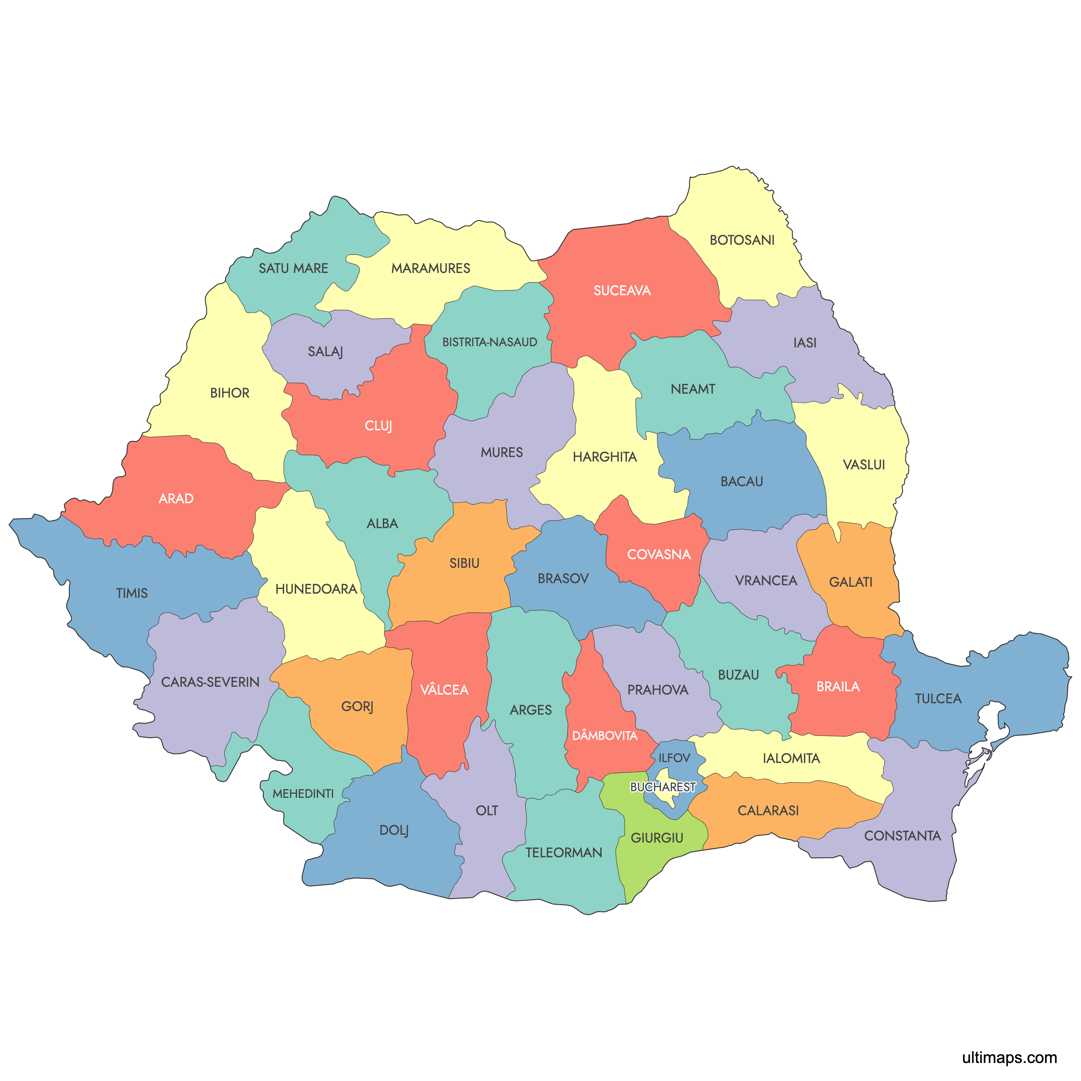
Map of Romania Counties
Romania is divided into 41 counties and the separate municipality of Bucharest, which holds county-level status. Together these 42 units span historic regions from Transylvania and Moldavia to Wallachia and Dobruja. Use the interactive maps below to explore county boundaries and major cities, download free reference maps, or create a custom map of Romania to visualize your own data.
Interactive Map of Romania Counties
List of Counties (42)
| # | County |
|---|---|
| 1 | |
| 2 | |
| 3 | |
| 4 | |
| 5 | |
| 6 | |
| 7 | |
| 8 | |
| 9 | |
| 10 | |
| 11 | |
| 12 | |
| 13 | |
| 14 | |
| 15 | |
| 16 | |
| 17 | |
| 18 | |
| 19 | |
| 20 | |
| 21 | |
| 22 | |
| 23 | |
| 24 | |
| 25 | |
| 26 | |
| 27 | |
| 28 | |
| 29 | |
| 30 | |
| 31 | |
| 32 | |
| 33 | |
| 34 | |
| 35 | |
| 36 | |
| 37 | |
| 38 | |
| 39 | |
| 40 | |
| 41 | |
| 42 |
About Romania
Romania is administratively divided into counties, each known as a "județ." These serve as the main territorial units for local government and administration. Each county has its own capital city and unique boundaries that have evolved since the country’s modern formation in the 19th and 20th centuries.
Key facts about the Romania counties map:
- Number of counties: 41, plus the municipality of Bucharest
- Largest county by area: Timiș
- Most populous county: Iași (excluding Bucharest)
- Smallest county by area: Ilfov
- County capitals include cities such as Cluj-Napoca, Constanța, Timișoara, and Brașov
- Borders neighboring countries: Hungary, Serbia, Bulgaria, Ukraine, and Moldova
- Counties (județe) are the essential level for regional organization and data collection in Romania
- Established in their current form after administrative reforms in 1968
Free Downloads
You can download free blank Map of Romania Counties and other maps in high resolution PNG, SVG and PDF formats from the blank maps section of the site: Download Blank Map of Romania Counties
Custom Map Features
This map supports labels.
This map is divided into 42 counties.
Frequently Asked Questions
Romania has 41 counties (județe) plus the municipality of Bucharest, which operates at county level, for a total of 42 first-level administrative units. These also serve as the country's NUTS-3 statistical subdivisions within the EU. The modern county system was re-established in 1968 when Romania replaced its Soviet-style regions and raions, and boundaries have remained largely stable since.
Timiș County is the largest, covering 8,697 km² (3,358 sq mi). Its county seat is Timișoara, a major city in western Romania known as the first European city with electric street lighting and for its central role in the 1989 Revolution.
Ilfov County is the smallest, covering 1,583 km² (611 sq mi). It encircles the capital Bucharest and is heavily suburbanized despite its compact size. Ilfov's proximity to the capital makes it one of the most economically dynamic counties in the country.
Iași County is the most populous, with about 760,000 inhabitants according to the 2021 census. Its county seat, Iași, is the historical capital of Moldavia and home to the Palace of Culture, numerous churches, and several major universities. Bucharest itself is more populous than any county but is classified as a separate municipality rather than a county.
Bran Castle, often associated with the Dracula legend, is in Brașov County, which also features the Black Church and Poiana Brașov ski resort. Peleș Castle, the former royal residence, sits in Sinaia within Prahova County. The Painted Monasteries of Bucovina, a UNESCO World Heritage group including Voroneț and Sucevița, are in Suceava County, while the Danube Delta Biosphere Reserve, one of Europe's largest wetlands, is in Tulcea County.
Romania shares borders with five countries: Ukraine to the north and northeast, the Republic of Moldova to the east, Bulgaria to the south, Serbia to the southwest, and Hungary to the west. The Black Sea forms Romania's eastern coastline, primarily along Constanța and Tulcea counties. The Danube River traces much of the southern border with Bulgaria and passes through numerous counties including Mehedinți, Dolj, Giurgiu, Brăila, and Tulcea.
You can use Ultimaps to create custom maps of Romania. Color-code counties manually or upload your data, place pins, customize the look, and export to PNG, PDF, or SVG. No sign-up required.