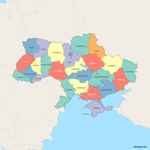
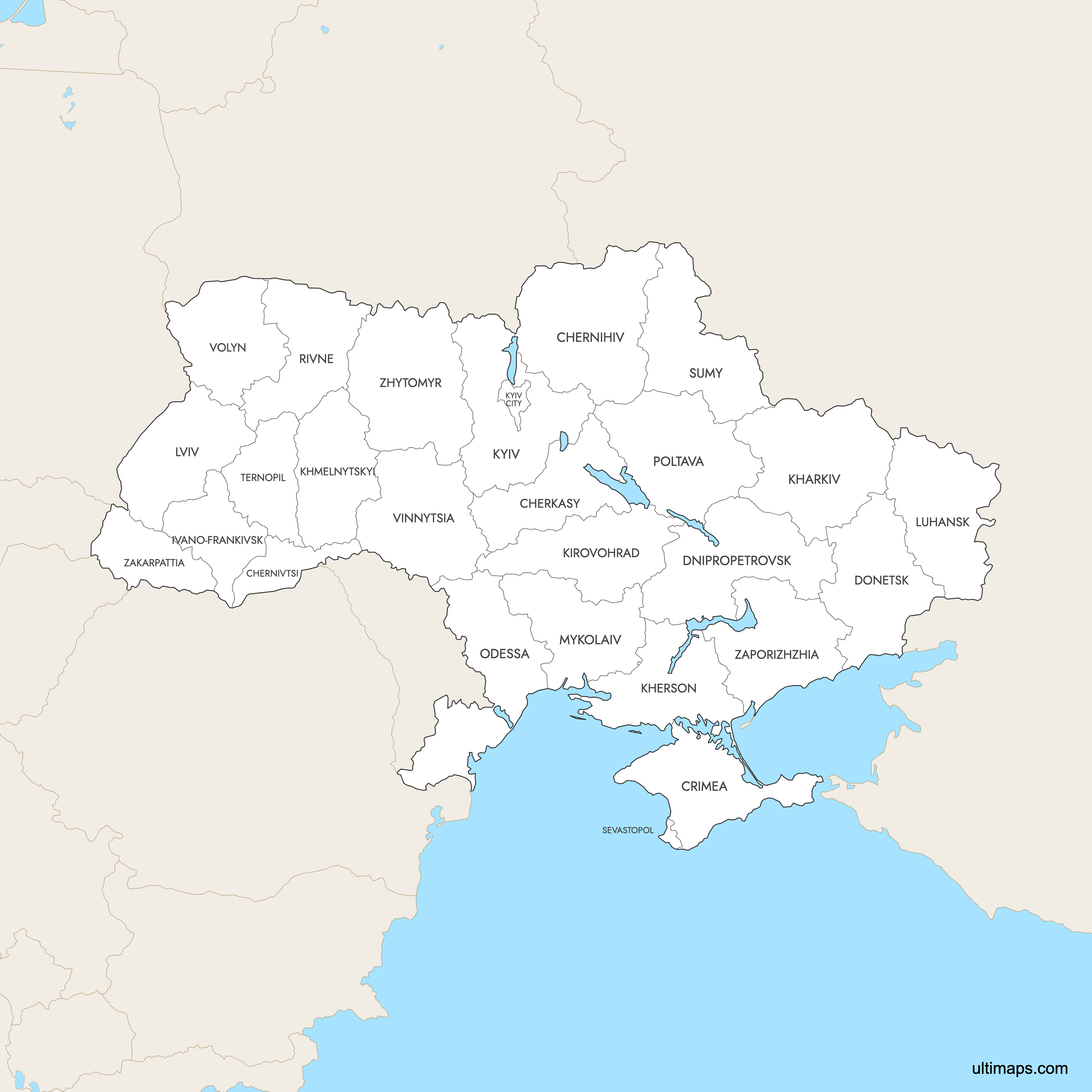
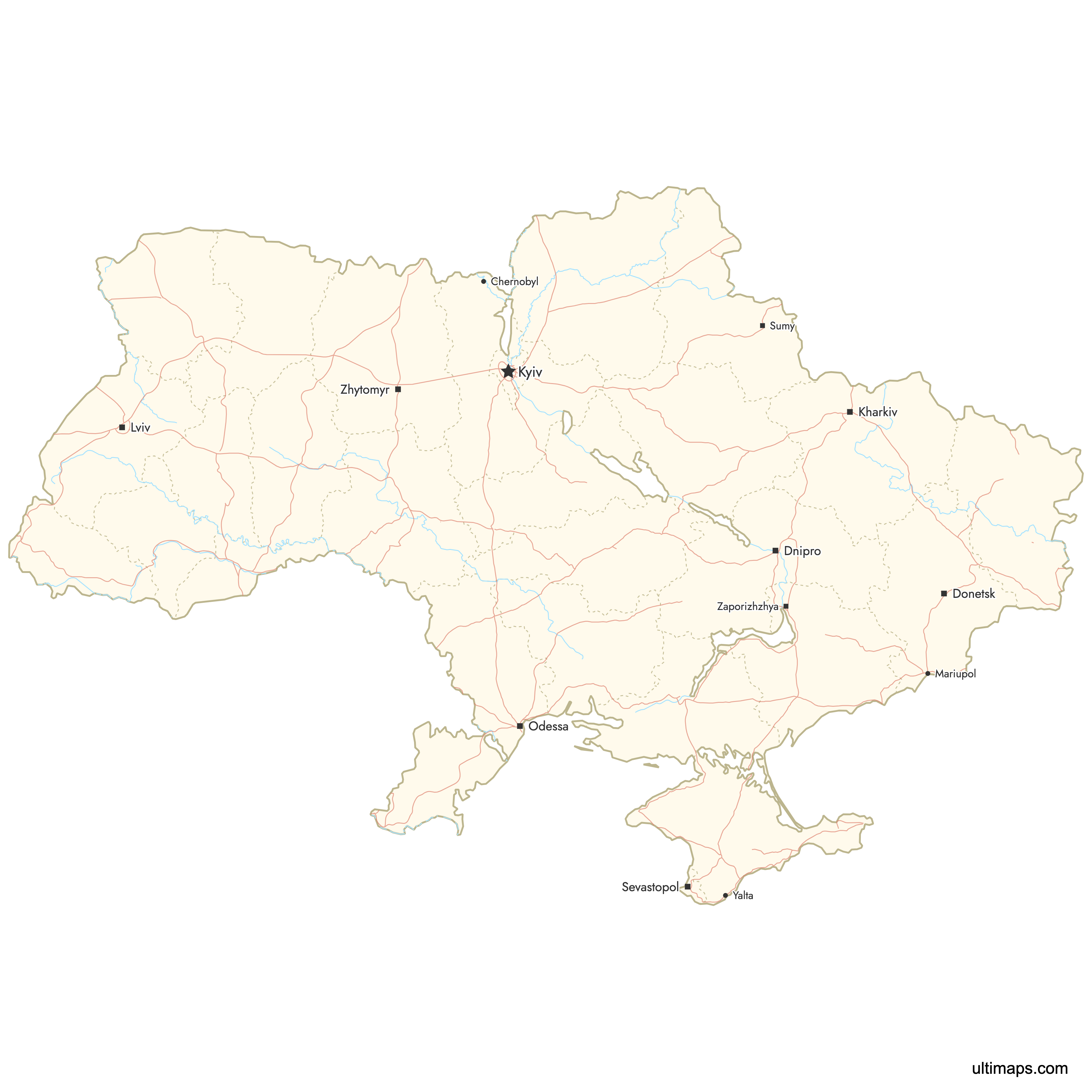
Map of Ukraine Regions
Ukraine is divided into 24 oblasts (regions), one autonomous republic (Crimea), and two cities with special status (Kyiv and Sevastopol), totaling 27 first-level administrative divisions. These oblasts serve as the primary units for regional governance and are further subdivided into raions and hromadas following a major 2020 administrative reform. Use the interactive maps below to explore Ukraine's regions and their boundaries. Download free maps or learn more about creating a custom map of Ukraine to visualize your own data.
Interactive Map of Ukraine Regions
List of Regions (27)
| # | Region |
|---|---|
| 1 | |
| 2 | |
| 3 | |
| 4 | |
| 5 | |
| 6 | |
| 7 | |
| 8 | |
| 9 | |
| 10 | |
| 11 | |
| 12 | |
| 13 | |
| 14 | |
| 15 | |
| 16 | |
| 17 | |
| 18 | |
| 19 | |
| 20 | |
| 21 | |
| 22 | |
| 23 | |
| 24 | |
| 25 | |
| 26 | |
| 27 |
Ukraine Regions: Key Facts
- Total number of regions: 27 first-level administrative divisions, consisting of 24 oblasts, 1 autonomous republic (Crimea), and 2 cities with special status (Kyiv and Sevastopol).
- Most populous oblast: Kyiv Oblast with approximately 1,775,000 people (2022 data), surrounding the capital city of Kyiv (pop. ~3 million).
- Least populous oblast: Chernihiv Oblast with approximately 994,000 people (2022 data).
- Largest oblast by area: Chernihiv Oblast at 31,851.3 km² (12,299 sq mi).
- Smallest oblast by area: Chernivtsi Oblast at 8,093.6 km² (3,125 sq mi).
- Major urban centers: Kyiv (national capital, ~3 million), Kharkiv (second-largest city, major industrial and university hub), Dnipro, Odesa (Black Sea port), and Donetsk (pre-conflict industrial center).
- Capital: Kyiv, which holds special administrative status separate from Kyiv Oblast.
- Borders: Russia (northeast and east), Belarus (north), Poland, Slovakia, Hungary, Romania, and Moldova (west and southwest). The Black Sea and Sea of Azov form the southern coastline.
- Time zone: Eastern European Time (UTC+2), with Eastern European Summer Time (UTC+3) in summer. Russian-occupied Crimea uses Moscow Time (UTC+3).
- Boundary history: The current 24-oblast structure was largely established after World War II, with additional oblasts created from border okruhas in 1937. A major 2020 reform reduced the number of raions (districts) from approximately 490 to 136 for administrative efficiency.
Interesting Facts
- Ukraine is the largest country entirely within Europe by area, with roughly 95% of its territory consisting of flat terrain on the East European Plain. Mountains are limited to the Eastern Carpathians in Zakarpattia Oblast and the Crimean Mountains.
- Chernihiv Oblast is both the largest oblast by area and the least populous, highlighting the dramatic variation in population density across Ukraine's regions.
- Chernivtsi Oblast, the smallest by area, is home to the UNESCO-listed Residence of Bukovinian and Dalmatian Metropolitans, one of Ukraine's most recognized architectural landmarks.
- The Chernobyl Exclusion Zone, site of the 1986 nuclear disaster, lies near the northern border of Kyiv Oblast and has become an unusual tourist destination.
- Ukraine's highest peak, Hoverla (2,061 m), is located in the Carpathian Mountains within Zakarpattia Oblast.
Free Downloads
 Colored Map of Ukraine Regions with Surrounding Areaspng870 KB
 Labeled Map of Ukraine Regions with Surrounding Areaspng857 KB
 Map of Ukraine Regions with Citiespng1012 KB

You can download free blank Map of Ukraine Regions and other maps in high resolution PNG, SVG and PDF formats from the blank maps section of the site: Download Blank Map of Ukraine Regions
Custom Map Features
This map supports labels.
This map supports surrounding areas, roads, rivers and cities. New
This map is divided into 27 regions.
Updates
Apr 23, 2026:
- Added map of Ukraine Regions with surrounding countries, cities and roads
Frequently Asked Questions
Ukraine has 27 first-level administrative divisions: 24 oblasts (regions), 1 autonomous republic (Crimea), and 2 cities with special status (Kyiv and Sevastopol). The oblasts are the primary regional units used for governance and administration. Following a 2020 reform, each oblast is further subdivided into raions (districts) and hromadas (communities).
Chernihiv Oblast is the largest oblast by area at 31,851.3 km² (12,299 sq mi). It is located in northern Ukraine, bordering both Russia and Belarus. Despite being the largest region, it is also the least populous oblast with approximately 994,000 residents (2022 data).
Chernivtsi Oblast is the smallest oblast by area at 8,093.6 km² (3,125 sq mi). Located in southwestern Ukraine near the Romanian and Moldovan borders, it is home to the city of Chernivtsi and the UNESCO-listed Residence of Bukovinian and Dalmatian Metropolitans.
Kyiv Oblast is the most populous oblast with approximately 1,775,000 people (2022 data). It surrounds the capital city of Kyiv, which itself has a population of about 3 million and holds separate special administrative status. Together, the Kyiv metropolitan area forms Ukraine's largest population center.
Kyiv, the capital, is home to two UNESCO World Heritage Sites: St. Sophia's Cathedral and Kyiv Pechersk Lavra. Odesa Oblast features the famous Black Sea port city of Odesa with its iconic Potemkin Stairs. Khmelnytskyi Oblast contains the historic Kamianets-Podilskyi fortress, while Ivano-Frankivsk Oblast offers the Carpathian National Nature Park and access to Ukraine's highest peak, Hoverla.
You can use Ultimaps to create custom maps of Ukraine. Color-code regions manually or upload your data, place pins, customize the look and feel, and export to PNG, PDF, or SVG. No sign-up required.
Kyiv is the capital of Ukraine and holds special administrative status as a city separate from any oblast. It is surrounded by Kyiv Oblast but is not part of it. With a population of approximately 3 million, Kyiv is the country's largest city and its political, economic, and cultural center.
Ukraine borders seven countries: Russia to the northeast and east, Belarus to the north, and Poland, Slovakia, Hungary, Romania, and Moldova to the west and southwest. Its southern coastline is formed by the Black Sea and the Sea of Azov. This makes Ukraine one of the most geographically connected countries in Europe.
Ukraine's current 24-oblast structure was largely set after World War II, with some oblasts created from border okruhas as early as 1937. The most recent major administrative change came in July 2020, when a decentralization reform reduced the number of raions (districts) from approximately 490 to 136 and introduced hromadas (communities) as a new local governance unit.
Crimea is officially the Autonomous Republic of Crimea with its administrative center in Simferopol. It has been occupied by Russia since 2014 and is internationally recognized as Ukrainian territory by most countries. Notable locations include Yalta with the historic Livadia Palace and Sevastopol, a major naval base that holds separate special-status city designation.