Israel Districts Map
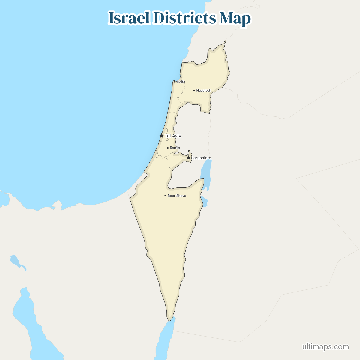
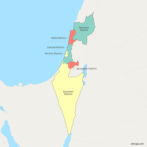
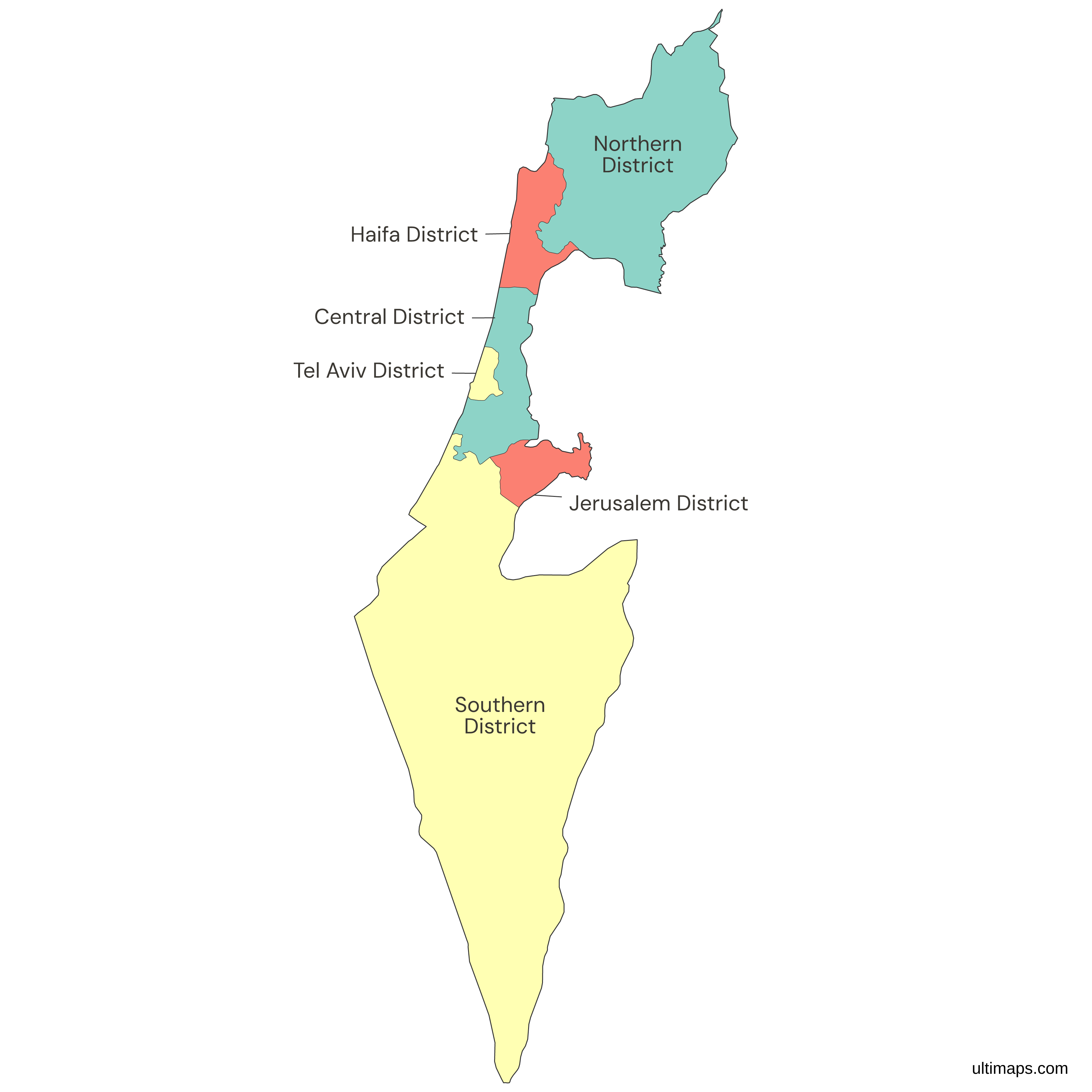
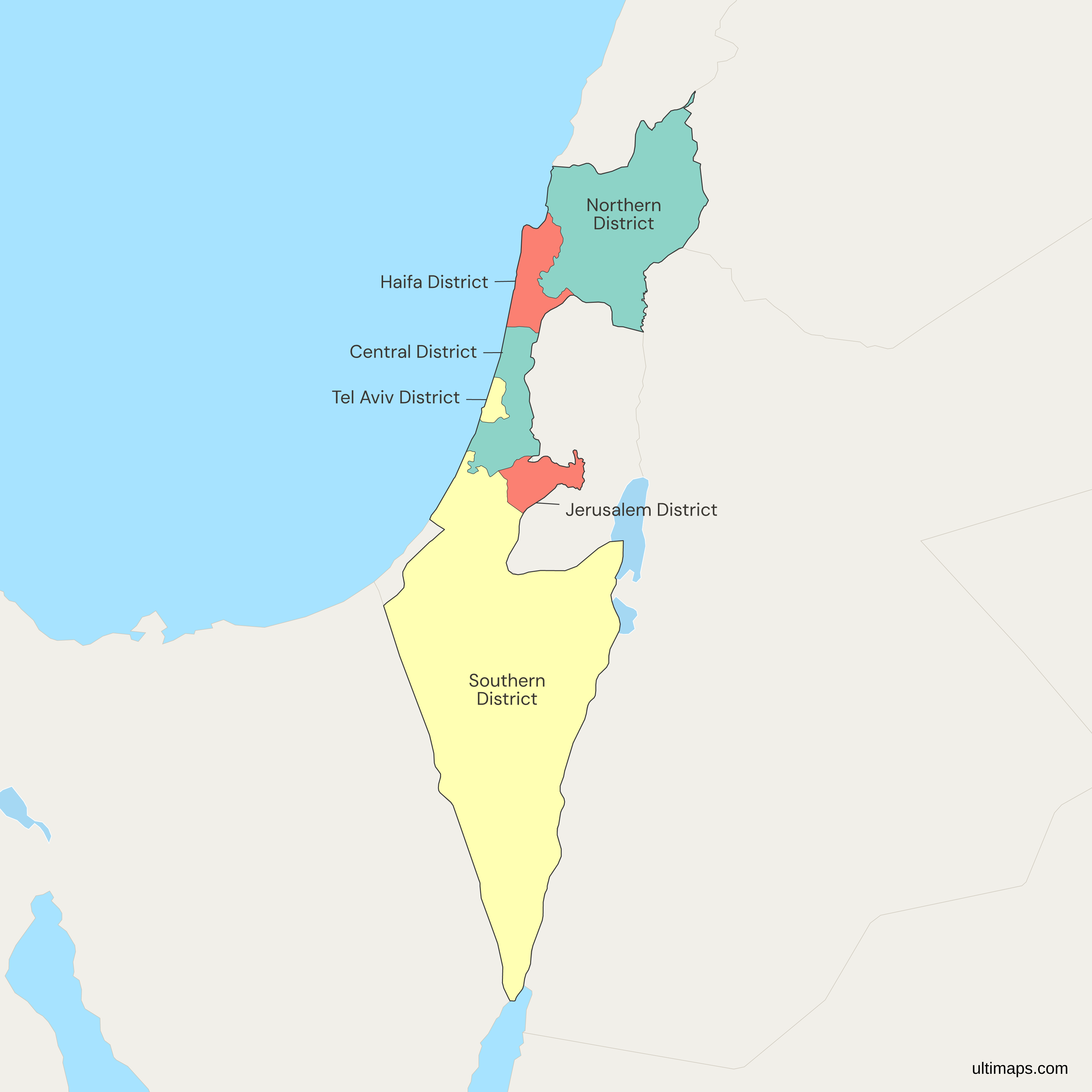
Israel's district map has 6 units: the Northern, Haifa, Central, Tel Aviv, Jerusalem and Southern districts, called mehozot in Hebrew. The Central Bureau of Statistics (CBS) treats them as the country's first-level division, the regions or provinces of other countries, and splits them into 15 subdistricts. The Southern District covers 14,185 km² (5,477 sq mi), most of it the Negev desert, while the Tel Aviv District measures just 172 km² (66 sq mi). At the CBS end-2021 estimate the Central District had the most residents, 2,304,300, and the Haifa District the fewest, 1,092,700. Jerusalem, the national capital, is also the seat of the Jerusalem District, and the other seats are Nof HaGalil, Haifa, Ramla, Tel Aviv and Beersheba.
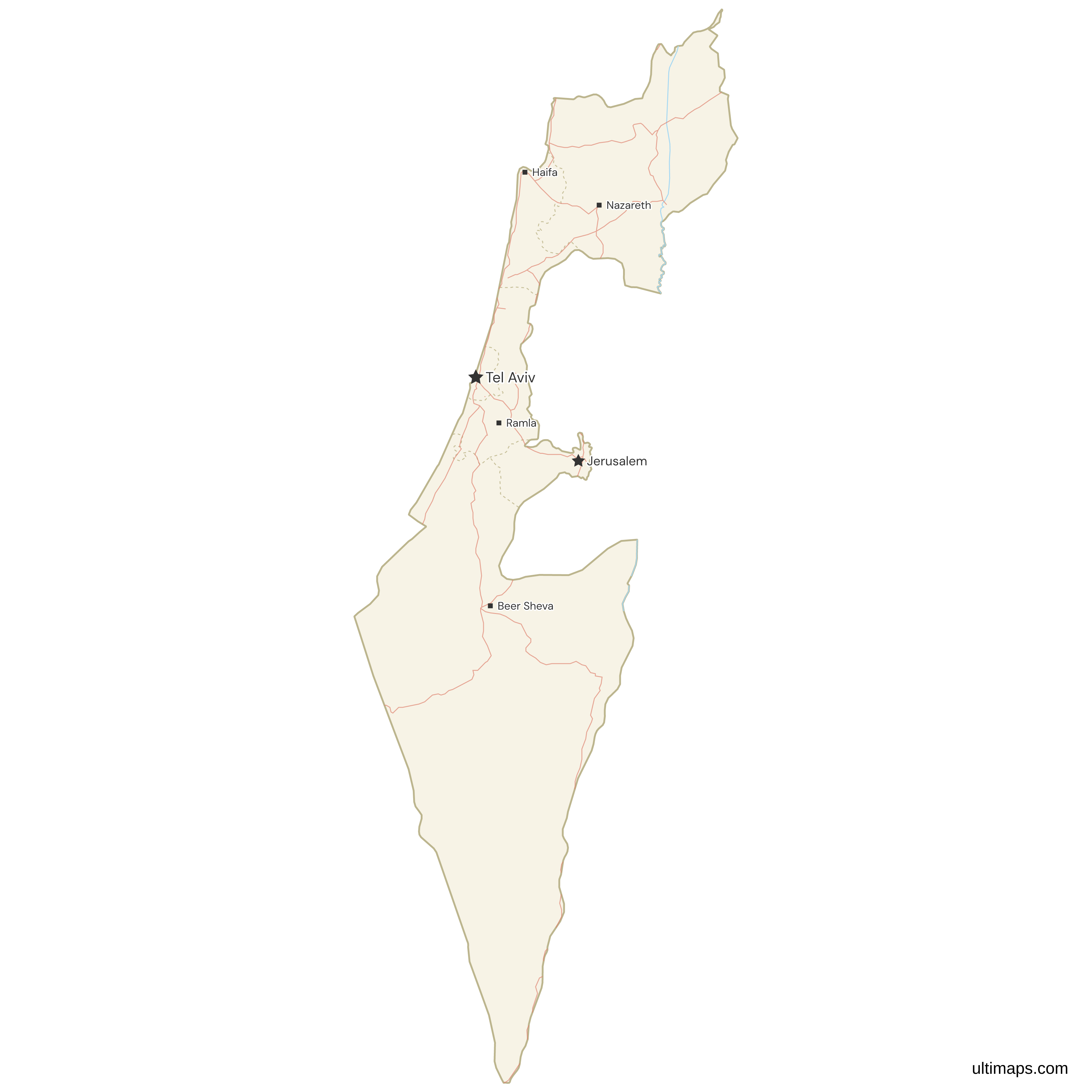
The map follows Israeli administration, so the Golan Heights sit inside the Northern District and East Jerusalem inside the Jerusalem District. Israel has held both since 1967, and their annexation is not recognized internationally. The West Bank and the Gaza Strip are drawn as surrounding territory, not as districts, and the CBS reports the Judea and Samaria Area, Israel's administrative term for the West Bank, outside the six. Zoom into the coastal strip, where the Tel Aviv, Central and Haifa boundaries run only a few kilometers apart, or color the districts with your own figures in the editor.
Interactive Israel Districts Map
List of Districts (6)
| # | District |
|---|---|
| 1 | Central District |
| 2 | Haifa District |
| 3 | Jerusalem District |
| 4 | Northern District |
| 5 | Southern District |
| 6 | Tel Aviv District |
Israel Districts: Key Facts
- Total number of districts: 6 (Northern, Haifa, Central, Tel Aviv, Jerusalem, Southern), further divided into 15 subdistricts
- Most populous district: Central District, 2,304,300 residents (CBS, end-2021 estimate), administered from Ramla
- Least populous district: Haifa District, 1,092,700 residents (CBS, end-2021 estimate)
- Largest district by area: Southern District, 14,185 km² (5,477 sq mi, CBS), covering the Negev
- Smallest district by area: Tel Aviv District, 172 km² (66 sq mi, CBS; some atlases round it up to 176 km²)
- Districts with major urban centers: Tel Aviv District holds Tel Aviv, Ramat Gan and Holon. Haifa District holds Haifa and Hadera. Central District holds Ramla, Netanya and Petah Tikva. Southern District holds Beersheba, Ashdod, Ashkelon and Eilat. Northern District holds Nazareth, Tiberias, Acre, Nahariya and Afula. Jerusalem District holds Jerusalem and Beit Shemesh
- Capital and administrative centers: Jerusalem is the national capital and the seat of the Jerusalem District. The six district seats are Nof HaGalil, Haifa, Ramla, Tel Aviv, Jerusalem and Beersheba
- Borders: Lebanon to the north, Syria to the northeast, Jordan to the east, Egypt to the southwest, the Mediterranean Sea along the western coast, and the Gulf of Aqaba, an arm of the Red Sea, at the southern tip near Eilat. The West Bank and the Gaza Strip adjoin the districts and are drawn as surrounding territory
- Time zone: Israel Standard Time (UTC+2), switching to Israel Daylight Time (UTC+3) in summer. All six districts keep the same clock
- Historical note: the six districts were set up in 1953 to replace the divisions inherited from the British Mandate, and a 1957 proclamation confirmed their boundaries, which have changed little since
Interesting Facts
- The Southern District covers 14,185 km² (5,477 sq mi), more land than the other five districts combined, yet it held 1,386,000 residents at the CBS end-2021 estimate, fewer than the Central District's 2,304,300.
- Three districts carry the name of their seat (Haifa, Tel Aviv, Jerusalem) and three are named by direction, with seats at Nof HaGalil, Ramla and Beersheba.
- The gap between largest and smallest is roughly 82 to 1: 14,185 km² in the south against 172 km² in Tel Aviv (both CBS).
- The Northern District includes the Golan Heights, and the Jerusalem District includes East Jerusalem, both administered by Israel since 1967 without international recognition of the annexation.
- The Northern District has five subdistricts, the most of any district, one of them the Golan, while the Tel Aviv and Jerusalem districts each consist of a single subdistrict.
Free Downloads
Free for personal and commercial use with a credit to Ultimaps. See the license terms for details.
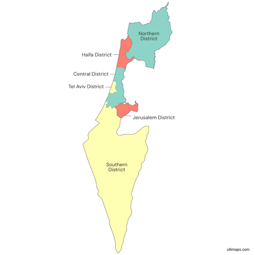 Colored Israel Districts Mappng273 KB
 Political Map of Israel with Districtspng385 KB
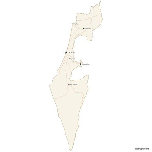 Map of Israel with Cities and Roadspng336 KB
Need it without colors? The blank version of this map comes as a print-ready PDF (A4 and US Letter), a PNG and an editable SVG.
Custom Map Features
This map supports labels.
This map supports surrounding areas, roads, rivers and cities. New
This map is divided into 6 districts.
Updates
May 14, 2026:
- Added map of Israel Districts with surrounding countries, cities and roads
Frequently Asked Questions
Israel has 6 administrative districts: Northern, Haifa, Central, Tel Aviv, Jerusalem and Southern. In Hebrew they are called mehozot, and they form the country's first-level division, the equivalent of provinces elsewhere. Below them sit 15 subdistricts, known as nafot, and below those are cities, local councils and regional councils. All 6 districts are drawn on the map on this page. Israel's Central Bureau of Statistics also publishes figures for the Judea and Samaria Area, which is administered separately and is not counted among the six, so a total of seven units sometimes appears in CBS-derived tables.
The Southern District is Israel's largest district by area at 14,185 km² (5,477 sq mi, CBS), covering the Negev and running down to the Gulf of Aqaba at Eilat. It is administered from Beersheba and also contains Ashdod and Ashkelon. The Northern District comes second at roughly 4,473 km² (1,727 sq mi), less than a third of that total, followed by the Central District at 1,294 km² (500 sq mi) and the Haifa District at 866 km² (334 sq mi), all per the CBS. Size does not track population here: the Southern District recorded 1,386,000 residents at the CBS end-2021 estimate, well behind the Central District, because much of its territory is desert.
The Central District is Israel's most populated district, with 2,304,300 residents at the Central Bureau of Statistics end-2021 estimate. It is run from Ramla and takes in Netanya and Petah Tikva on the coastal plain. The Northern District followed with 1,513,600 and the Tel Aviv District with 1,481,400, although Tel Aviv fits those residents into only 172 km² (66 sq mi, CBS), making it the most densely settled of the six by a wide margin. The Southern District recorded 1,386,000, the Jerusalem District 1,209,700, and the Haifa District 1,092,700, the lowest figure among the districts (all end-2021 CBS estimates).
The Tel Aviv District is Israel's smallest district, covering 172 km² (66 sq mi) in the CBS tables, though some atlases round it up to 176 km². It still held 1,481,400 residents at the CBS end-2021 estimate, which makes it the most densely populated unit in the country, and it forms the core of the Gush Dan metropolitan area with Tel Aviv, Ramat Gan and Holon inside it. For comparison, the Southern District is about 82 times larger at 14,185 km² (5,477 sq mi). The Jerusalem District ranks second smallest at roughly 652 km² (252 sq mi), ahead of the Haifa District at 866 km² (334 sq mi).
Jerusalem lies in the Jerusalem District and serves as both Israel's national capital and that district's administrative seat. The district covers about 652 km² (252 sq mi), recorded 1,209,700 residents at the CBS end-2021 estimate, and includes Beit Shemesh along with East Jerusalem, which Israel administers as part of the district and which is not internationally recognized as Israeli territory. Tel Aviv sits in the Tel Aviv District, one of three districts named after their central city, the others being Haifa and Jerusalem. The remaining three carry directional names, with seats at Nof HaGalil for the north, Ramla for the center and Beersheba for the south.
The map draws Israel's 6 districts as Israeli administration defines them, so the Golan Heights are part of the Northern District and East Jerusalem is part of the Jerusalem District. Israel has held both since 1967, and neither annexation is recognized internationally. The West Bank and the Gaza Strip are not districts: they appear as surrounding territory, outside the six colored units. Israel's Central Bureau of Statistics reports the Judea and Samaria Area, its administrative term for the West Bank, alongside the district tables rather than inside them, which is why a total of seven units sometimes appears in CBS-derived data.
Israel has no states, provinces or counties. Its first-level units are the 6 districts, called mehozot, and the second level consists of 15 subdistricts, called nafot. Local government runs through cities, local councils and regional councils, while the districts serve as a framework for state administration and statistics, with no elected assemblies of their own. Names like the Galilee, the Sharon plain and the Negev describe geographic regions, not administrative ones, and they cross district lines: the Negev lies almost entirely in the Southern District, while the Galilee is mostly in the Northern District. If you are looking for a map of Israel's states or provinces, the district map is the correct match.
Israel's six district capitals are Nof HaGalil (called Nazareth Illit until 2019) for the Northern District, Haifa for the Haifa District, Ramla for the Central District, Tel Aviv for the Tel Aviv District, Jerusalem for the Jerusalem District and Beersheba for the Southern District. Jerusalem carries two roles, since it is also the national capital. Three of the six districts take their name directly from their seat, while Northern, Central and Southern are named by direction. Nazareth, the Northern District's largest city, sits beside its smaller administrative seat. Ramla is the least prominent of the seats and is considerably smaller than Netanya and Petah Tikva, the biggest cities in the Central District it administers.
A custom Israel map starts right on this page, in a browser-based editor that is free to use without an account. You can color the districts from data, pasting one value for each of the 6 districts to get a scale with a legend, or pick colors district by district, giving the Negev one tone and the coastal districts another. Fonts, outline weight and the background are adjustable, labels can be rewritten, and pins from Eilat up to Nahariya can carry short captions. A free export is a standard PNG with a small Ultimaps credit, and high-resolution PNG, SVG and PDF exports come with a Pro plan.