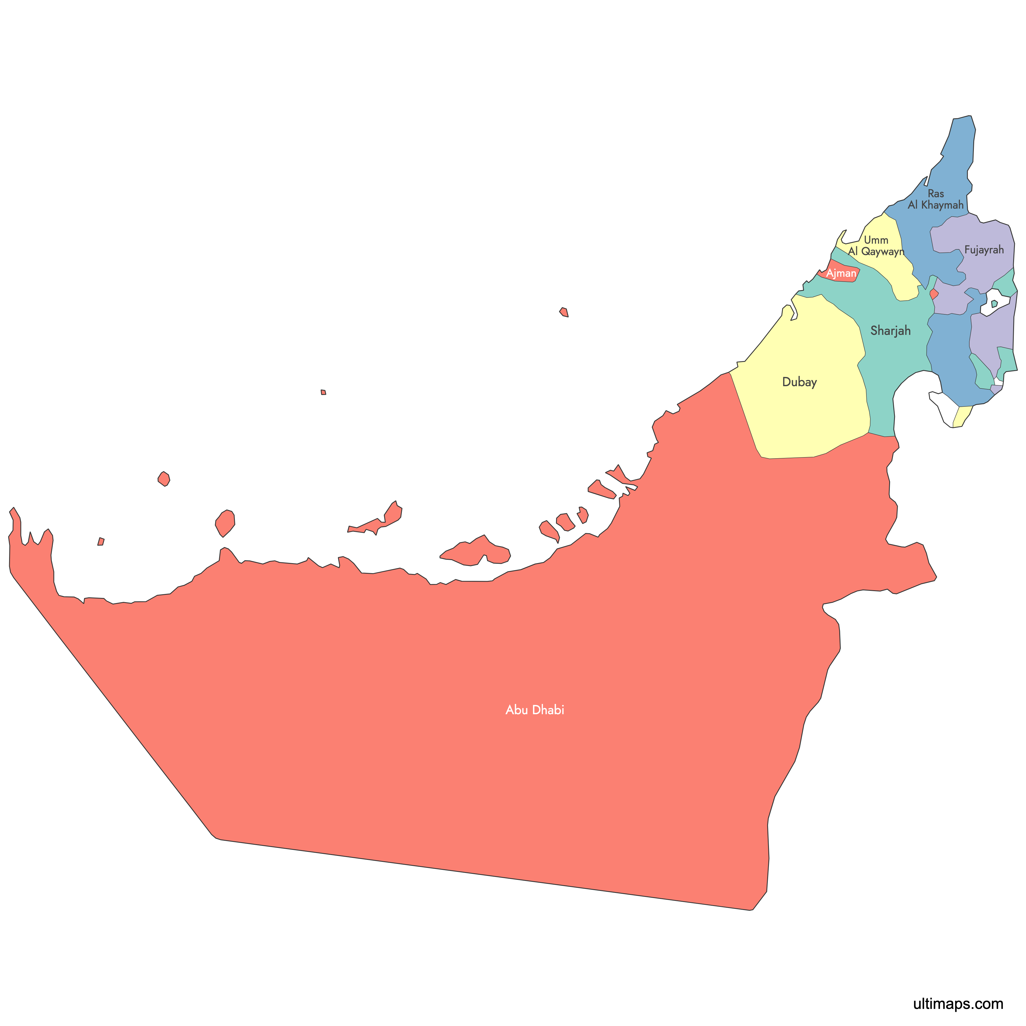
Map of United Arab Emirates
The United Arab Emirates consists of seven emirates, each with unique features and significance. Explore the federal structure and geographic diversity of the UAE through our interactive maps. Download free maps or learn about creating custom maps of the UAE to showcase your data.
Interactive Map of United Arab Emirates
List of Emirates (7)
| # | Emirate |
|---|---|
| 1 | |
| 2 | |
| 3 | |
| 4 | |
| 5 | |
| 6 | |
| 7 |
United Arab Emirates: Key Facts
- Political structure: Federal elective monarchy of seven emirates
- Capital city: Abu Dhabi
- Largest city: Dubai
- Total area: 83,600 km² (32,300 mi²)
- Land boundaries: 867 km total - Saudi Arabia (457 km), Oman (410 km)
- Coastline length: 1,318 km
- Neighboring states (land): Saudi Arabia, Oman
- Neighboring states (maritime): Iran, Qatar
- Population: Approximately 10 million
- Time zone: UTC +4
Interesting Facts
- Extreme urbanization: Population concentrated in coastal strip from Abu Dhabi to Ras Al Khaimah
- Unique dual-coast emirate: Sharjah has coastlines on both the Persian Gulf and Gulf of Oman
- Strategic location: Fujairah provides direct access to the Indian Ocean, bypassing the Strait of Hormuz
- Man-made geography: Dubai's coast features artificial islands like Palm Jumeirah
Free Downloads
You can download free blank Map of United Arab Emirates and other maps in high resolution PNG, SVG and PDF formats from the blank maps section of the site: Download Blank Map of United Arab Emirates
Custom Map Features
This map supports labels.
This map is divided into 7 emirates.
Updates
Sep 12, 2024:
- Added labeled version
Apr 14, 2024:
- Added map of UAE
Frequently Asked Questions
The United Arab Emirates is in the Middle East, on the northeastern edge of the Arabian Peninsula, bordered by the Persian Gulf and the Gulf of Oman.
The UAE shares land borders with Saudi Arabia to the west and south (457 km) and Oman to the east and northeast (410 km).
The UAE consists of seven emirates: Abu Dhabi, Dubai, Sharjah, Ajman, Umm Al Quwain, Ras Al Khaimah, and Fujairah.
Abu Dhabi is the largest emirate by area, covering 67,340 km² (26,000 mi²), approximately 87% of the UAE's total land area.
You can use Ultimaps to create custom maps of the UAE. Color-code emirates manually or upload data, place pins, customize the look and feel, and export to PNG, PDF, or SVG.