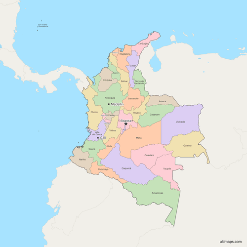
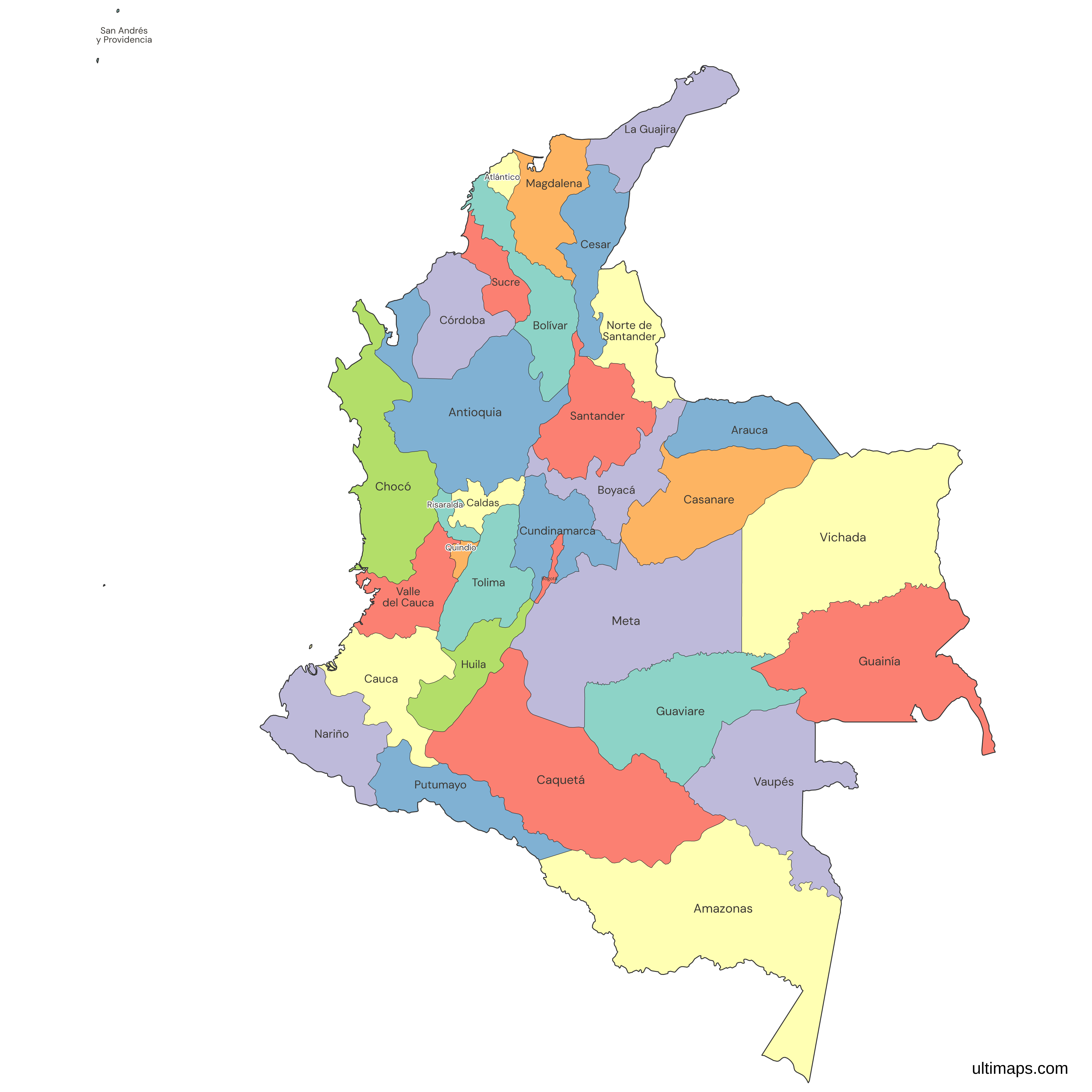
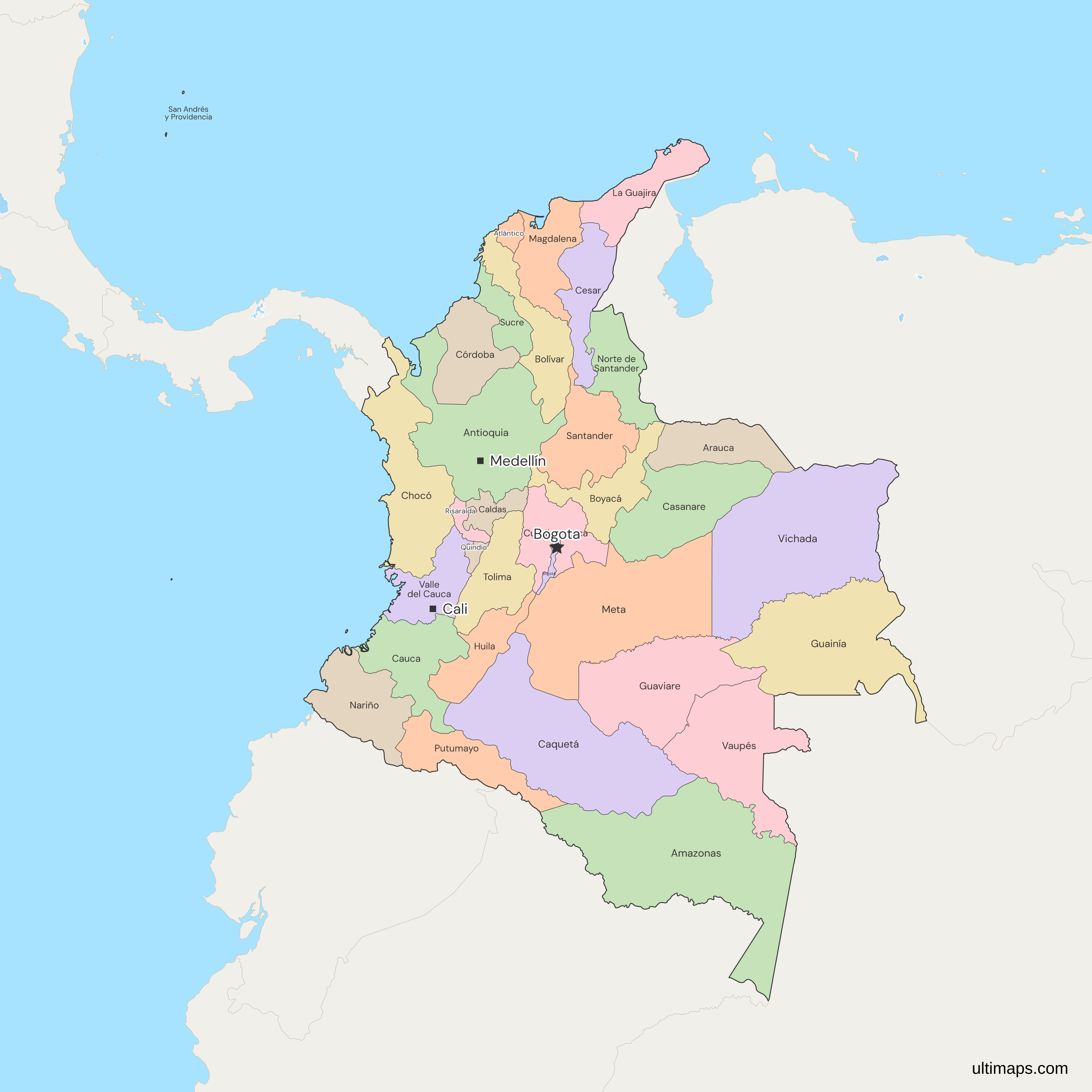
Colombia Map with Departments
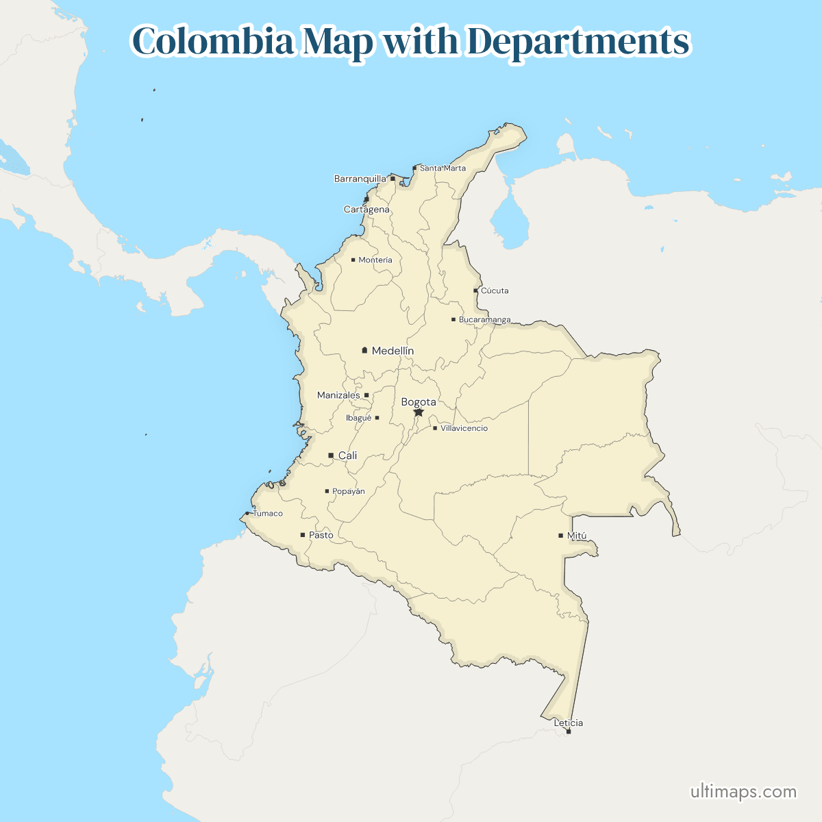
This map of Colombia shows all 32 departments and the Capital District of Bogotá, 33 first-level units in all. Colombia has no states, and the department system was last widened in 1991, when the Constitution made nine former intendencias and comisarías departments. Bogotá, the national capital, has 7.9 million people (DANE, 2026 projection), more than Antioquia, the most populous department, with 7.0 million (DANE, 2026). Amazonas is the largest department at 109,497 km² (IGAC, 2024).
Open the map in the free Ultimaps editor to make your own custom map of Colombia. You can color the departments by your data, add pins and labels, and share or embed the finished map.
Interactive Colombia Map with Departments
List of Departments (33)
| # | Department | Capital | Population (2026) | Area (km², 2024) |
|---|---|---|---|---|
| 1 | Amazonas | Leticia | 85,896 | 109,497.05 |
| 2 | Antioquia | Medellín | 6,963,990 | 62,808.63 |
| 3 | Arauca | Arauca | 280,022 | 23,851.26 |
| 4 | Atlántico | Barranquilla | 2,885,904 | 3,314.45 |
| 5 | Bogotá | Bogotá | 7,945,996 | 1,620.05 |
| 6 | Bolívar | Cartagena | 2,251,190 | 26,719.97 |
| 7 | Boyacá | Tunja | 1,295,848 | 23,138.05 |
| 8 | Caldas | Manizales | 1,056,839 | 7,425.25 |
| 9 | Caquetá | Florencia | 431,867 | 92,831.28 |
| 10 | Casanare | Yopal | 477,966 | 44,394.23 |
| 11 | Cauca | Popayán | 1,613,329 | 31,242.80 |
| 12 | Cesar | Valledupar | 1,493,824 | 22,565.31 |
| 13 | Chocó | Quibdó | 599,468 | 48,353.21 |
| 14 | Córdoba | Montería | 2,014,312 | 25,086.22 |
| 15 | Cundinamarca | Bogotá | 3,601,277 | 22,370.37 |
| 16 | Guainía | Inírida | 61,065 | 71,289.35 |
| 17 | Guaviare | San José del Guaviare | 84,833 | 55,543.85 |
| 18 | Huila | Neiva | 1,221,847 | 18,141.66 |
| 19 | La Guajira | Riohacha | 1,082,618 | 20,618.62 |
| 20 | Magdalena | Santa Marta | 1,558,748 | 23,135.94 |
| 21 | Meta | Villavicencio | 1,166,652 | 82,830.41 |
| 22 | Nariño | Pasto | 1,721,735 | 31,497.54 |
| 23 | Norte de Santander | Cúcuta | 1,717,792 | 21,856.75 |
| 24 | Putumayo | Mocoa | 395,590 | 25,976.28 |
| 25 | Quindío | Armenia | 557,850 | 1,933.57 |
| 26 | Risaralda | Pereira | 1,006,785 | 3,556.75 |
| 27 | San Andrés y Providencia | San Andrés | 63,527 | 49.42 |
| 28 | Santander | Bucaramanga | 2,410,700 | 30,561.52 |
| 29 | Sucre | Sincelejo | 1,047,052 | 10,591.86 |
| 30 | Tolima | Ibagué | 1,390,982 | 24,139.52 |
| 31 | Valle del Cauca | Cali | 4,714,987 | 20,665.66 |
| 32 | Vaupés | Mitú | 44,490 | 53,299.28 |
| 33 | Vichada | Puerto Carreño | 154,190 | 100,063.37 |
Data sources:
- Capital: DANE, DIVIPOLA (cut of 30 December 2024); Constitución Política de Colombia art. 322. License: facts compiled by Ultimaps, CC BY 4.0.
- Population: DANE, departmental population projections 2018-2050 (CNPV 2018 base, July 2025 update), 2026 projection. License: use with citation under DANE terms. Fuente: Departamento Administrativo Nacional de Estadística: www.dane.gov.co
- Area: IGAC, Extensión (km²), via DNP TerriData. License: CC BY 4.0.
Colombia Departments: Key Facts
- Number of departments: 32 departments plus the Capital District of Bogotá, 33 first-level units, all drawn on the map.
- Capital: Bogotá, which is both the national capital and the Capital District. It is a unit of its own, separate from Cundinamarca, the department around most of it.
- Largest and smallest by area: Amazonas is the largest at 109,497 km² (IGAC, 2024) and Vichada is second at 100,063 km². San Andrés y Providencia is the smallest at 49 km², and Quindío is the smallest on the mainland at 1,934 km² (IGAC, 2024). Bogotá covers 1,620 km².
- Population: Antioquia is the most populous department with 6,963,990 people and Vaupés the least with 44,490 (DANE, 2026 projection). Bogotá has 7,945,996, and the whole country 53.4 million.
- Borders: Colombia has five land neighbors. Venezuela borders Guainía, La Guajira, Cesar, Norte de Santander, Boyacá, Arauca and Vichada. Guainía, Vaupés and Amazonas face Brazil, and Putumayo and Amazonas face Peru. Ecuador meets Nariño and Putumayo, and Panama meets only Chocó.
- Coast: The Caribbean coast belongs to La Guajira, Magdalena, Atlántico, Bolívar, Sucre, Córdoba and Antioquia, and the Pacific coast to Chocó, Valle del Cauca, Cauca and Nariño. Chocó has both, and San Andrés y Providencia is an island department in the Caribbean.
- Former territories: Arauca, Casanare, Putumayo and San Andrés y Providencia were intendencias, and Amazonas, Guaviare, Guainía, Vaupés and Vichada were comisarías, until the 1991 Constitution made them departments.
- Last change: No department has been created, merged or abolished since 1991. Bogotá's name changed in 2000, from Santa Fe de Bogotá to Bogotá, Distrito Capital, and the set stayed the same.
- Natural regions: The six regions usually taught are the Andean, Caribbean, Pacific, Orinoquía, Amazon and Insular. Mountains, plains and coasts set their edges, and several cut across departments, so the map leaves them out.
- Codes: ISO 3166-2 codes run from CO-AMA for Amazonas to CO-VID for Vichada, with CO-DC for Bogotá.
Interesting Facts
- Before 1886, Colombia was the United States of Colombia, a federation of nine states: Antioquia, Bolívar, Boyacá, Cauca, Cundinamarca, Magdalena, Panamá, Santander and Tolima. The 1886 Constitution turned them into departments.
- Malpelo Island, in the Pacific, belongs to Valle del Cauca and is drawn there. Gorgona Island belongs to Cauca.
- The map places the town of Belén de Bajirá in Chocó, as the IGAC's 2017 maps do. Antioquia disputes the line, and its case before the Consejo de Estado had no ruling as of November 2026.
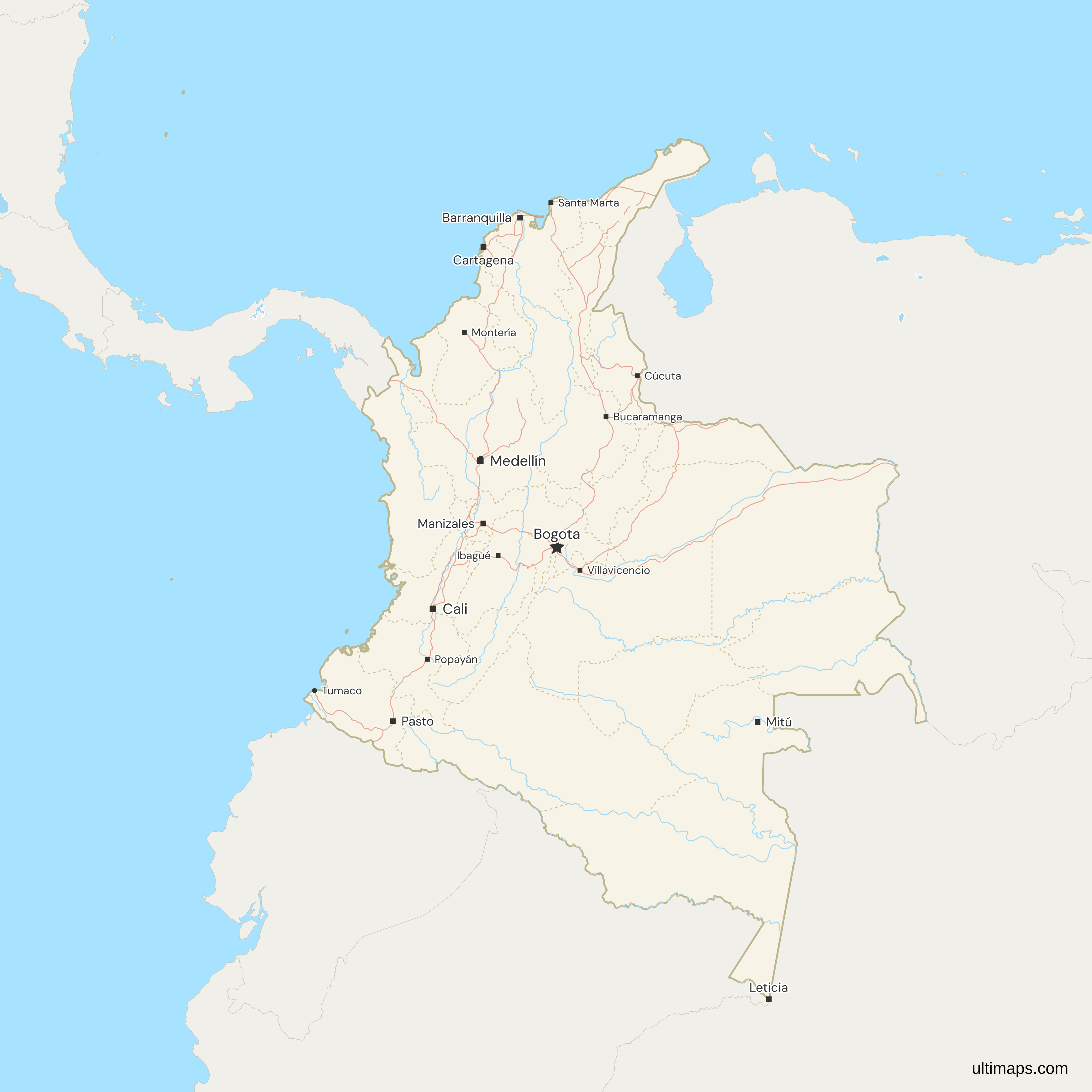
- The map's cities layer marks 18 places: Bogotá with the capital star, 15 department capitals, and Bello and Tumaco.
Free Downloads
Free for personal and commercial use with a credit to Ultimaps. See the license terms for details.
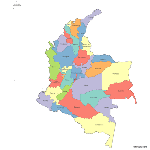 Colored Colombia Map with Departmentspng592 KB
 Political Map of Colombia with Departmentspng725 KB
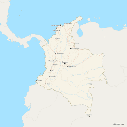 Map of Colombia with Cities and Roadspng831 KB
Need it without colors? The blank version of this map comes as a print-ready PDF (A4 and US Letter), a PNG and an editable SVG.
Custom Map Features
This map supports labels.
This map supports surrounding areas, roads, rivers and cities. New
This map is divided into 33 departments.
Updates
Nov 5, 2026:
- Added map of Colombia departments
Frequently Asked Questions
Colombia has 32 departments and the Capital District of Bogotá, 33 first-level units in all, and this map draws every one. Sources that say 32 leave out Bogotá, a district outside every department. The count has stood since the 1991 Constitution, whose article 309 turned the former intendencias of Arauca, Casanare, Putumayo and San Andrés y Providencia and the former comisarías of Amazonas, Guaviare, Guainía, Vaupés and Vichada into departments. Colombia's departamentos administrativos, such as DANE, are national government agencies with no territory of their own.
No, Colombia has no states, and it has had none since 1886. Its first-level units are departments, a system the 1886 Constitution set up in place of the nine states of the United States of Colombia. Those states were Antioquia, Bolívar, Boyacá, Cauca, Cundinamarca, Magdalena, Panamá, Santander and Tolima, and Panamá later left the country. Colombia's provinces, used in Boyacá, Cundinamarca and Santander, are groups of municipalities inside a department and not first-level units, although some English-language sources use the word for the departments.
Colombia's departments and their capitals are Amazonas (Leticia), Antioquia (Medellín), Arauca (Arauca), Atlántico (Barranquilla), Bolívar (Cartagena), Boyacá (Tunja), Caldas (Manizales), Caquetá (Florencia), Casanare (Yopal), Cauca (Popayán), Cesar (Valledupar), Chocó (Quibdó), Córdoba (Montería), Cundinamarca (Bogotá), Guainía (Inírida), Guaviare (San José del Guaviare), Huila (Neiva), La Guajira (Riohacha), Magdalena (Santa Marta), Meta (Villavicencio), Nariño (Pasto), Norte de Santander (Cúcuta), Putumayo (Mocoa), Quindío (Armenia), Risaralda (Pereira), San Andrés y Providencia (San Andrés), Santander (Bucaramanga), Sucre (Sincelejo), Tolima (Ibagué), Valle del Cauca (Cali), Vaupés (Mitú) and Vichada (Puerto Carreño). Bogotá is the capital of Cundinamarca under the Constitution, but as the Capital District it is a separate unit and not part of that department.
Colombia is usually taught as six natural regions: Andean, Caribbean, Pacific, Orinoquía, Amazon and Insular. Relief draws their edges instead of administrative lines, so most regions contain parts of several departments, and Antioquia, for one, is usually split between the Andean and Caribbean regions. The Insular region covers the island department of San Andrés y Providencia and Colombia's smaller islands in both seas, such as Gorgona and Malpelo. This map colors departments only. You can show the regions by coloring each department with the region where most of it lies, and Antioquia needs a choice because it is split. The regional planning administrations (RAP), which Law 1962 of 2019 strengthened, are a different arrangement, and they are not territorial units.
No, the municipalities are not drawn: this map of Colombia stops at the 33 first-level units. Departments are divided into municipalities, though parts of Amazonas, Guainía and Vaupés are non-municipalized areas and the island of San Andrés is not a municipality, and Bogotá is divided into localities. Several cities, including Barranquilla, Cartagena and Santa Marta, are districts with special status, but they are municipalities inside their departments, and only Bogotá stands outside any department. To show municipalities, add pins for individual towns. The map's cities layer marks only 18 places.
Amazonas covers 109,497 km² (IGAC, 2024), more than any other department in Colombia. Next come Vichada at 100,063 km², Caquetá at 92,831 km², Meta at 82,830 km² and Guainía at 71,289 km². Antioquia ranks sixth at 62,809 km², ahead of Guaviare at 55,544 km² and Vaupés at 53,299 km². Amazonas alone covers nearly a tenth of the country's 1.14 million km². The ten largest end with Casanare at 44,394 km², and the other 23 units are all below 32,000 km².
San Andrés y Providencia is an island department in the Caribbean, more than 700 km northwest of the mainland, and at 49 km² (IGAC, 2024) it is the smallest in Colombia. The map draws San Andrés, Providencia and Santa Catalina but not the smaller cays of the archipelago. On the mainland Quindío is smallest at 1,934 km², then Atlántico at 3,314 km² and Risaralda at 3,557 km². Bogotá, the Capital District, covers 1,620 km² but is a district and not a department.
Bogotá has 7,945,996 people (DANE, 2026 projection), more than any department, but it is a district. The most populous department is Antioquia with 6,963,990. Behind it come Valle del Cauca with 4,714,987 and Cundinamarca with 3,601,277. Vaupés has the fewest people of any department, at 44,490, and Guainía and San Andrés y Providencia are the next smallest. Bogotá and Antioquia together hold about 28 percent of the 53.4 million people DANE projects for the 33 units in 2026, a series based on the 2018 census.
Open the map in the free Ultimaps editor, which needs no account. To color the departments by hand, click each one. To color them by data, upload a table of department names and values, and list Bogotá under its own name because it is a separate unit. You can add pins and labels, then share the finished map by link or embed it on a website. A free export is a standard PNG with a small Ultimaps credit. High-resolution PNG, SVG and PDF export are Pro features.