Venezuela Map with States
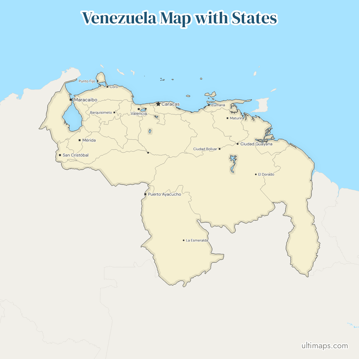
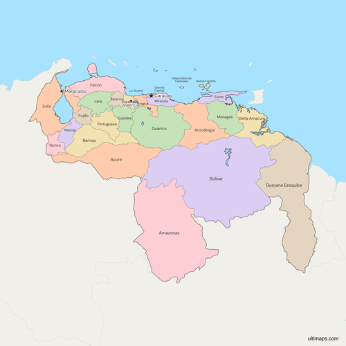
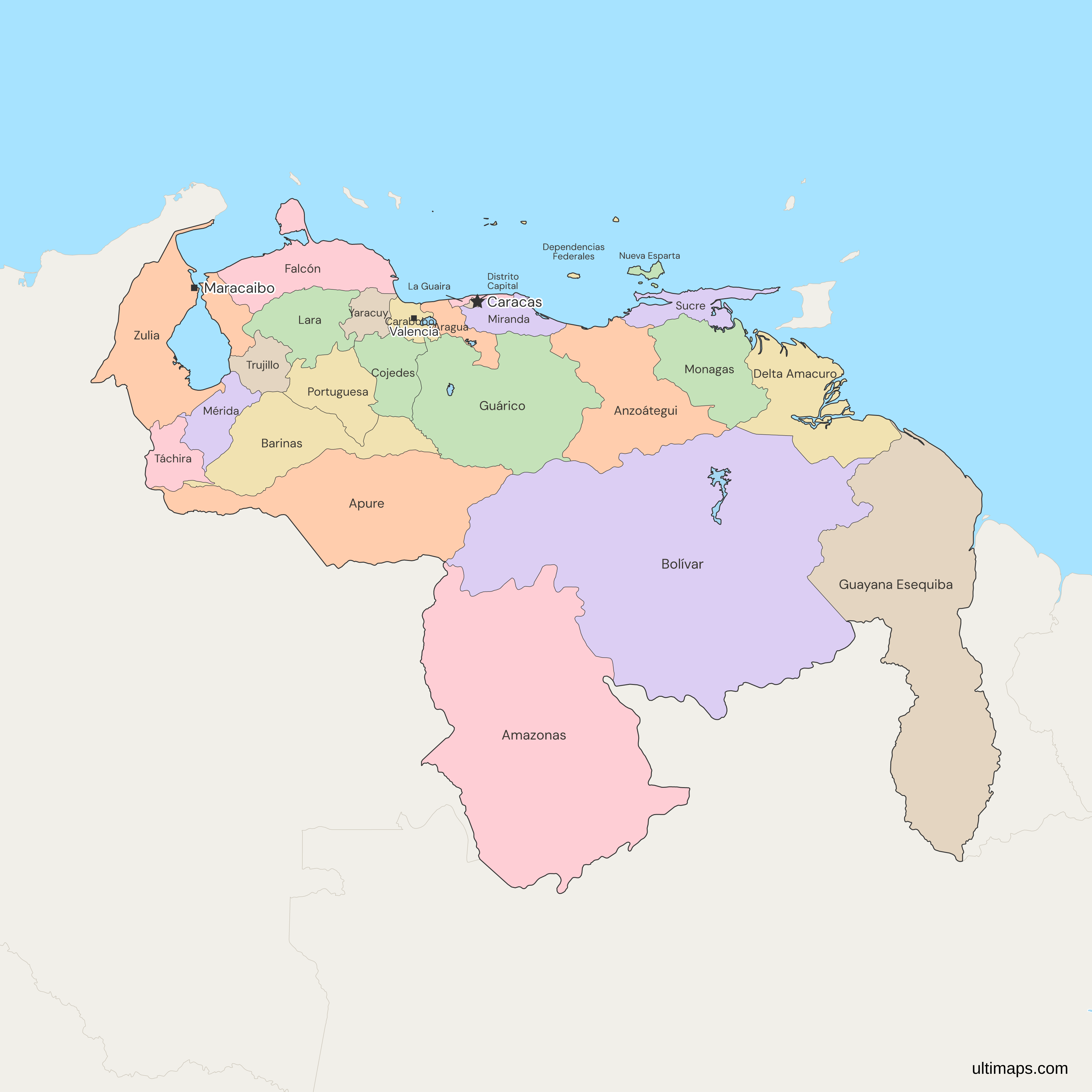
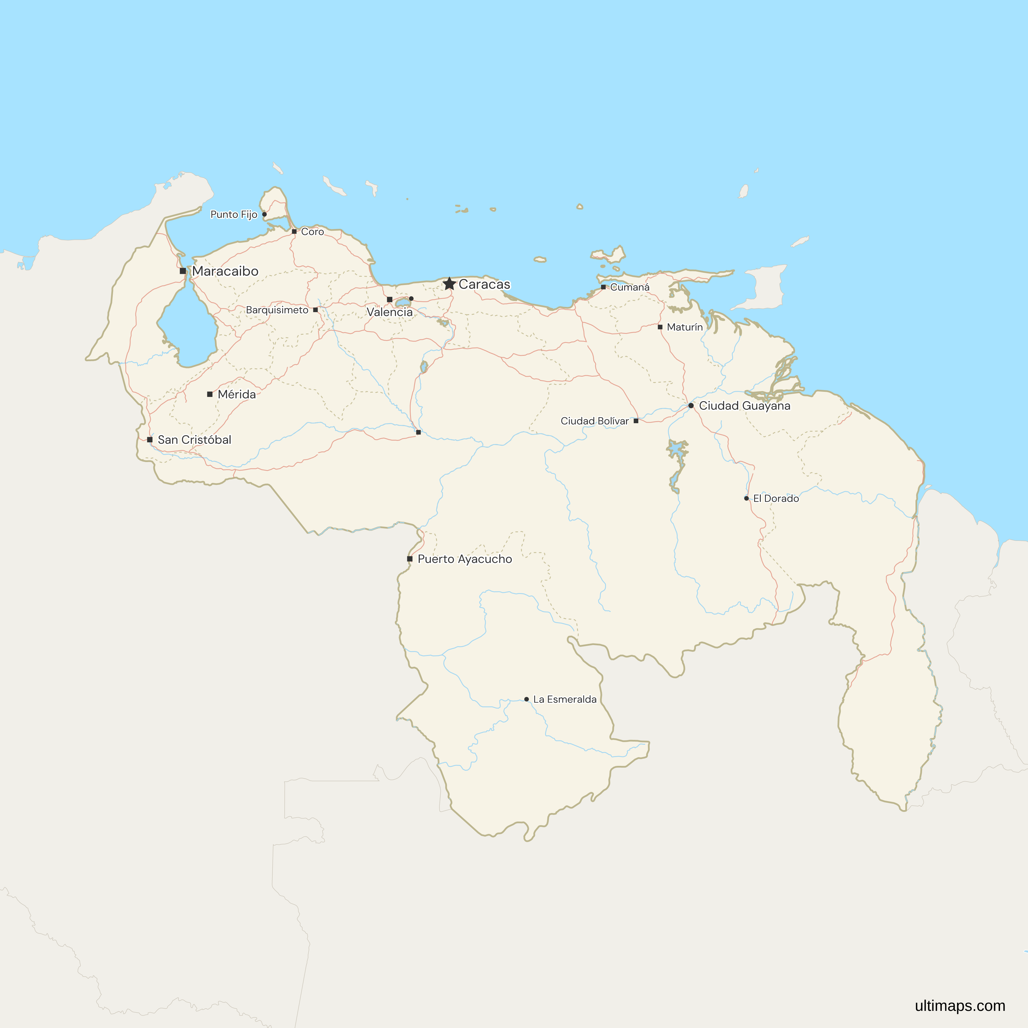
This map of Venezuela shows all 24 states: the 23 that ISO 3166-2 and most references list, and Guayana Esequiba, created by a Venezuelan law of 3 April 2024 on the land west of the Essequibo River. Guyana administers that territory, which Venezuela claims, and the case over it is before the International Court of Justice. With the Capital District and the Federal Dependencies, which are not states, the map has 26 divisions. The national capital, Caracas, covers the Capital District and part of Miranda. The Capital District alone had 1,943,901 people at the 2011 census. That census, Venezuela's most recent, ranked Zulia first of the states, at 3,704,404.
Open the map in the free Ultimaps editor to make your own custom map of Venezuela. You can color the states by your data, add pins and labels, and share or embed the finished map.
Interactive Venezuela Map with States
List of States (26)
| # | State | Capital | Population (2011) | Area (km², 2011) |
|---|---|---|---|---|
| 1 | Amazonas | Puerto Ayacucho | 146,480 | 177,617 |
| 2 | Anzoátegui | Barcelona | 1,469,747 | 43,300 |
| 3 | Apure | San Fernando de Apure | 459,025 | 76,500 |
| 4 | Aragua | Maracay | 1,630,308 | 7,014 |
| 5 | Barinas | Barinas | 816,264 | 35,200 |
| 6 | Bolívar | Ciudad Bolívar | 1,413,115 | 240,528 |
| 7 | Carabobo | Valencia | 2,245,744 | 4,650 |
| 8 | Cojedes | San Carlos | 323,165 | 14,800 |
| 9 | Delta Amacuro | Tucupita | 165,525 | 40,200 |
| 10 | Dependencias Federales | — | 2,155 | — |
| 11 | Distrito Capital | Caracas | 1,943,901 | 433 |
| 12 | Falcón | Coro | 902,847 | 24,800 |
| 13 | Guárico | San Juan de los Morros | 747,739 | 64,986 |
| 14 | Guayana Esequiba | — | — | — |
| 15 | La Guaira | La Guaira | 352,920 | 1497 |
| 16 | Lara | Barquisimeto | 1,774,867 | 19,800 |
| 17 | Mérida | Mérida | 828,592 | 11,300 |
| 18 | Miranda | Los Teques | 2,675,165 | 7,950 |
| 19 | Monagas | Maturín | 905,443 | 28,900 |
| 20 | Nueva Esparta | La Asunción | 491,610 | 1150 |
| 21 | Portuguesa | Guanare | 876,496 | 15,200 |
| 22 | Sucre | Cumaná | 896,291 | 11,800 |
| 23 | Táchira | San Cristóbal | 1,168,908 | 11,100 |
| 24 | Trujillo | Trujillo | 686,367 | 7,400 |
| 25 | Yaracuy | San Felipe | 600,852 | 7,100 |
| 26 | Zulia | Maracaibo | 3,704,404 | 63,100 |
Data sources:
- Capital: INE Venezuela, División Político Territorial con fines estadísticos (2013). License: facts compiled by Ultimaps, CC BY 4.0.
- Population: INE Venezuela, XIV Censo Nacional de Población y Vivienda 2011, Cuadro 2.2. License: no reuse licence published.
- Area: INE Venezuela, Censo 2011 state monographs. License: no reuse licence published.
Venezuela States: Key Facts
- Number of states: 24 under Venezuelan law, up from 23 before the law of April 2024. The Capital District and the Federal Dependencies, provided for in the 1999 Constitution, bring the map to 26 divisions. ISO 3166-2 lists 25 divisions: the 23 long-standing states, the Capital District and the Federal Dependencies. Guayana Esequiba is not among them, and the cartography that the National Institute of Statistics (INE) published before the 2024 law leaves it out too.
- Capital: Caracas. The Capital District is the city's Libertador municipality, 433 km² (INE, 2011). It replaced the Federal District, on the same land, under the 1999 Constitution. The rest of the city lies in Miranda.
- Largest and smallest: Bolívar (about 240,000 km²) and Amazonas (about 180,000 km²) are the two largest states and take up 46% of the country's 916,445 km² (INE, 2011). Nueva Esparta, an island state of 1,150 km², is the smallest.
- Population: At the 2011 census (INE), the three most populous states were Zulia (3,704,404), Miranda (2,675,165) and Carabobo (2,245,744). Amazonas, second in area, came last among the states with 146,480. The Federal Dependencies counted 2,155.
- Borders: Colombia lies along Zulia, Táchira, Apure and Amazonas, in the west and south. Brazil borders Amazonas and Bolívar, and on this map Guayana Esequiba too. Guyana touches only Guayana Esequiba here, along the Essequibo River. On maps that follow the boundary Guyana administers, such as the Guyana map, Guyana borders Delta Amacuro and Bolívar.
- Coast: 11 of the 23 long-standing states reach the sea. Zulia, Falcón, Carabobo, Aragua, La Guaira, Miranda, Anzoátegui, Sucre and Monagas face the Caribbean or the Gulf of Paria, Delta Amacuro faces the Atlantic, and Nueva Esparta is made of islands. Guayana Esequiba has the Atlantic coast east of Delta Amacuro. Trinidad and Tobago lies 11 km off Venezuela's coast, across the strait from Sucre's Paria peninsula.
- Lakes: Lake Maracaibo is drawn as water, outside Zulia's shape, though INE's 2011 figure of 63,100 km² for Zulia includes it. Zulia has most of its shore. Mérida touches the southeast corner, and Trujillo the east shore just north of it. Lago de Valencia, between Carabobo and Aragua, is water on the map too, and so are three reservoirs: Guri in Bolívar, Camatagua in Aragua and the Guárico reservoir in Guárico.
- Administrative regions: 9 groupings of states, a system that dates from 1969. Zulia is a region by itself, and the Capital region joins the Capital District with Miranda and La Guaira.
- Vargas and other changes since 1998: Vargas became a state on 31 December 1998 and took the name La Guaira in a reform of its state constitution on 14 June 2019, with the same territory and code. The 2024 law added Guayana Esequiba. No reform since 2000 has moved land between the other 25 divisions.
- Codes: ISO 3166-2:VE gives each of its 25 divisions one letter. VE-A is the Capital District, VE-B to VE-V (skipping Q) are 20 states in alphabetical order from Anzoátegui to Zulia, and VE-W is the Federal Dependencies. The three states created in the 1990s took the last letters: Delta Amacuro VE-Y, Amazonas VE-Z and La Guaira VE-X.
- Municipalities: 335, in the 23 long-standing states and the Capital District, which is one municipality by itself. The Federal Dependencies have none.
Interesting Facts
- Cities on the map: Caracas carries the capital star, and 11 state capitals have a capital square: Maracaibo, Valencia, San Cristóbal, Mérida, Puerto Ayacucho, Barquisimeto, Maturín, Ciudad Bolívar, Cumaná, Coro and San Fernando de Apure. Maracay, the capital of Aragua, appears as an ordinary city, and the other state capitals, Los Teques and La Guaira among them, are not drawn. Natural Earth, the map's source, lists the towns west of the Essequibo as Guyana's, so no city is marked in Guayana Esequiba.
- Seat and vote outside the state: Guayana Esequiba's provisional seat, Tumeremo, and the district that elected its governor on 25 May 2025 both lie in Bolívar.
Free Downloads
Free for personal and commercial use with a credit to Ultimaps. See the license terms for details.
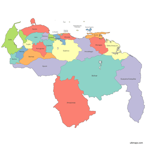 Colored Venezuela Map with Statespng570 KB
 Political Map of Venezuela with Statespng611 KB
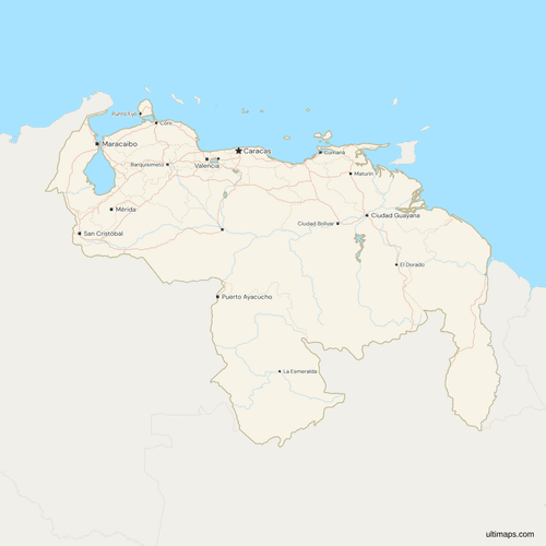 Map of Venezuela with Cities and Roadspng744 KB
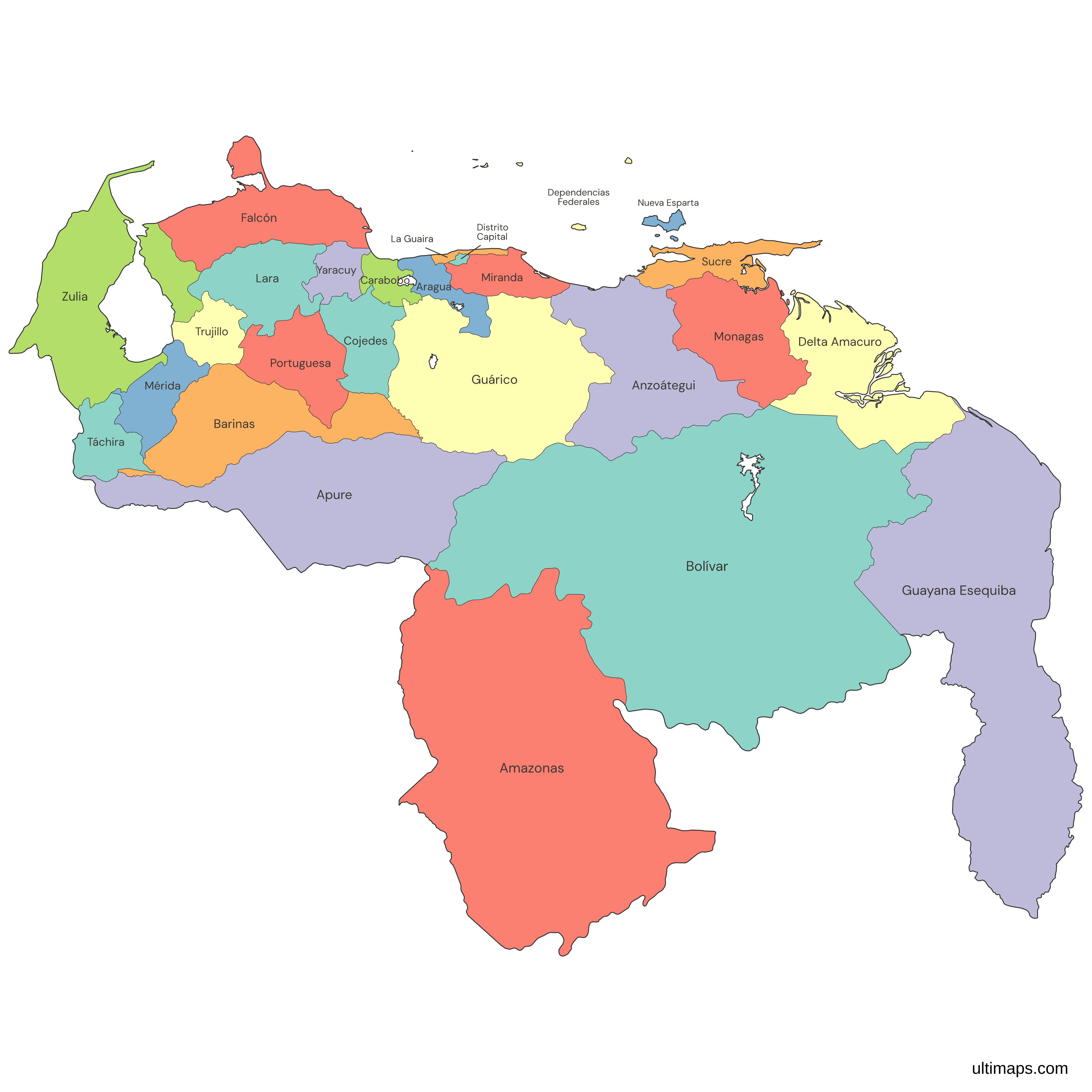
Need it without colors? The blank version of this map comes as a print-ready PDF (A4 and US Letter), a PNG and an editable SVG.
Custom Map Features
This map supports labels.
This map supports surrounding areas, roads, rivers and cities. New
This map is divided into 26 states.
Updates
Nov 5, 2026:
- Added map of Venezuela states
Frequently Asked Questions
Venezuelan law has counted 24 states since April 2024, while ISO 3166-2 and most English references count 23. The difference is Guayana Esequiba, which that law made a state on territory Guyana administers and Venezuela claims. The map follows the Venezuelan count of 24. Two more divisions, provided for in the 1999 Constitution, are not states: the Capital District, in Caracas, and the Federal Dependencies, the offshore islands outside any state. Venezuela uses states, or estados, rather than provinces or departments, and below them are 335 municipalities.
Caracas, the national capital, is the Capital District's seat, and Venezuela's 23 long-standing states have these capitals: Amazonas (Puerto Ayacucho), Anzoátegui (Barcelona), Apure (San Fernando de Apure), Aragua (Maracay), Barinas (Barinas), Bolívar (Ciudad Bolívar), Carabobo (Valencia), Cojedes (San Carlos), Delta Amacuro (Tucupita), Falcón (Coro), Guárico (San Juan de los Morros), La Guaira (La Guaira), Lara (Barquisimeto), Mérida (Mérida), Miranda (Los Teques), Monagas (Maturín), Nueva Esparta (La Asunción), Portuguesa (Guanare), Sucre (Cumaná), Táchira (San Cristóbal), Trujillo (Trujillo), Yaracuy (San Felipe) and Zulia (Maracaibo). La Guaira was called Vargas until 2019. The National Institute of Statistics (INE) lists no capital for the Federal Dependencies. For Guayana Esequiba, the 2024 law sets only a provisional seat for its authorities: Tumeremo, in Bolívar.
Guayana Esequiba is a state under Venezuelan law, and this map includes it as the 24th state. The Organic Law for the Defense of Guayana Esequiba, of 3 April 2024, created it on the land west of the Essequibo River, about two-thirds of the territory Guyana administers. The case over the 1899 arbitral award on the boundary is pending at the International Court of Justice. Venezuela claims the land, and Guyana administers it. ISO 3166-2 gives the state no code, and the National Institute of Statistics (INE) has no population or area for it. The map of Guyana draws the same land inside Guyana's ten regions, and the map of South America draws it as part of Guyana.
Venezuela's administrative regions date from a decree of 11 June 1969, which set eight. The present list has nine: Andean (Barinas, Mérida, Táchira, Trujillo), Capital (Capital District, Miranda, La Guaira), Central (Aragua, Carabobo, Cojedes), Central-Western (Falcón, Lara, Portuguesa, Yaracuy), Guayana (Amazonas, Bolívar, Delta Amacuro), Insular (Nueva Esparta and the Federal Dependencies), Llanos (Apure, Guárico), Northeastern (Anzoátegui, Monagas, Sucre) and Zulian (Zulia). The regions do not all follow this map's lines: Apure's Páez municipality belongs to the Andean region, and the rest of Apure to the Llanos. Guayana Esequiba, created in 2024, is not one of the nine. Some Spanish-language lists add it to the Guayana region. The natural regions, such as the Andes, follow relief rather than state lines.
The largest state in Venezuela is Bolívar, at about 240,000 km² in 2011 figures from the National Institute of Statistics (INE), more than a quarter of the 916,445 km² INE gives for the country. Amazonas, to its southwest, is second at about 180,000 km², and the two together cover 46% of Venezuela. Apure (76,500 km²), Guárico (64,986 km²) and Zulia (63,100 km², Lake Maracaibo included) are next in INE's figures. Guayana Esequiba, the 2024 state, has no official area, but on the map it is smaller than Bolívar and Amazonas, so the two largest do not change.
Nueva Esparta, Venezuela's smallest state, is made up of the Caribbean islands of Margarita, Coche and Cubagua, with its capital, La Asunción, on Margarita. It covers 1,150 km² in 2011 figures from the National Institute of Statistics (INE). La Guaira, at 1,497 km², is the smallest state on the mainland, on the coast north of Caracas. The Capital District and the Federal Dependencies are not states, and both are smaller than Nueva Esparta. The Capital District covers 433 km². The Federal Dependencies are smaller still: INE gives no total, but the island areas it lists come to under 400 km².
The Federal Dependencies of Venezuela are the offshore islands that belong to no state, under articles 16 and 17 of the 1999 Constitution. They have no municipalities, and the National Institute of Statistics (INE) names no capital. The 2011 census counted 2,155 people in three of INE's 15 island groups: Los Roques, Los Testigos and Chimanas. Since 2011, Los Roques, La Orchila and Las Aves have formed the Francisco de Miranda Insular Territory. The map draws La Tortuga, La Blanquilla, La Orchila, Los Roques and Las Aves as one unit. Isla de Aves, about 550 km north of the mainland, belongs to them but is not drawn: it is below the map's 1 km² minimum for islands.
Zulia leads Venezuela's states in population, with 3,704,404 people at the 2011 census of the National Institute of Statistics (INE), which counted 27,227,930 nationwide. Miranda (2,675,165), Carabobo (2,245,744) and Lara (1,774,867) come next among the states. The Capital District, which is not a state, had 1,943,901 people, fewer than the top three states and more than Lara. The 2011 count is still the latest by state: a 15th census was decreed in September 2019 but had not been held by November 2026. INE did not count Guayana Esequiba. Guyana's 2022 census counts the people there by Guyanese region, but those regions do not follow the Essequibo, so no total for the state can be taken from it.
A custom map of Venezuela starts from this map in the free Ultimaps editor, and you can begin without signing up. Color the states by hand or paste a table of values. Names match with or without accents or the word Estado, so Tachira matches Táchira. Vargas matches La Guaira, Caracas matches the Capital District, and Essequibo matches Guayana Esequiba. ISO codes such as VE-V work for the other 25 divisions. Pins can add unmarked capitals such as Los Teques. You need a free account to save, publish, share a link or embed the map. The free export is a standard PNG with a small Ultimaps credit, and Ultimaps Pro is needed for high-resolution PNG, SVG and PDF.