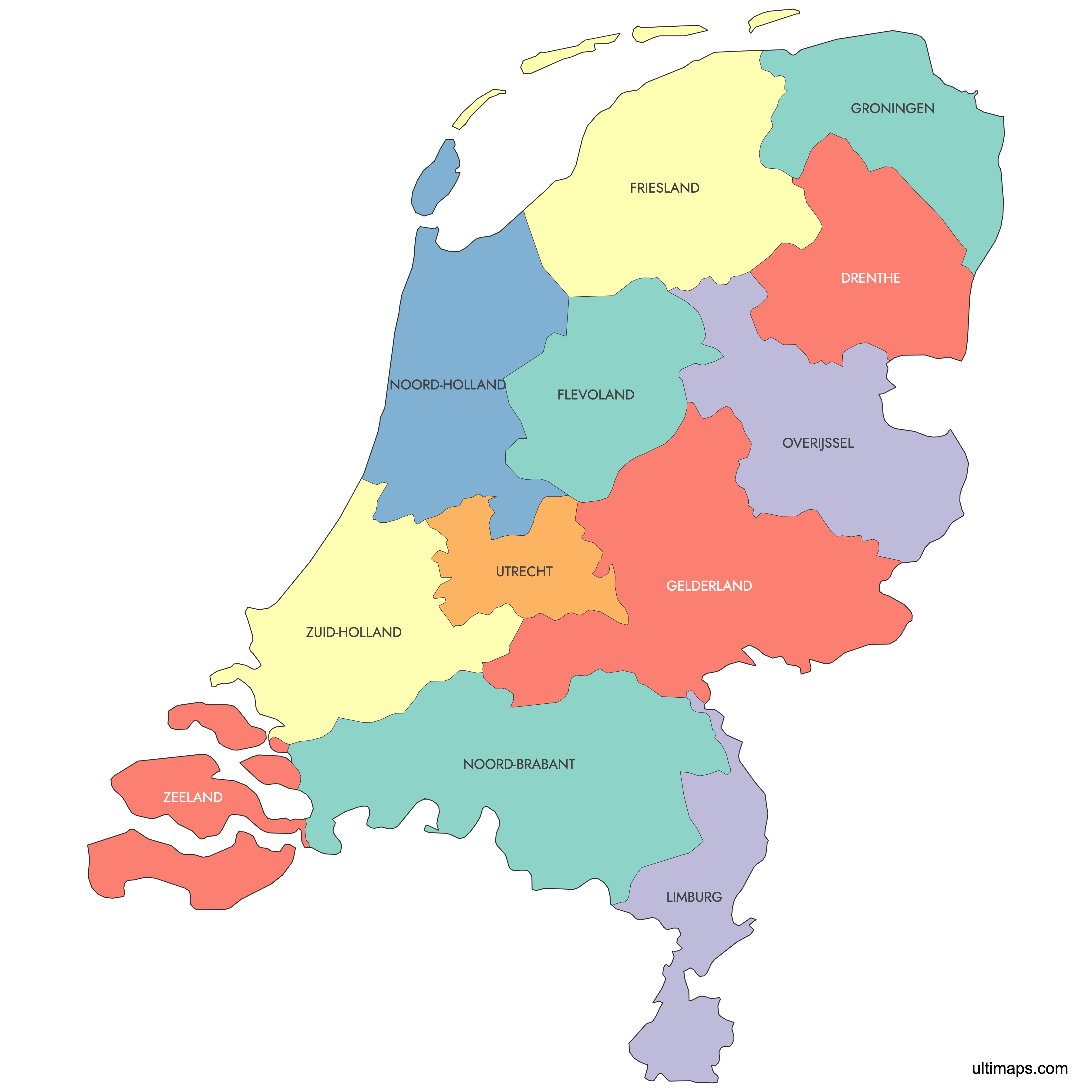
Map of Netherlands Provinces
The Netherlands is divided into 12 provinces, each with its own capital, government, and distinct character. Use the interactive maps below to explore provincial boundaries, capitals, and major cities. Download free reference maps or learn more about creating a custom map of the Netherlands to visualize your own data.
Interactive Map of Netherlands Provinces
List of Provinces (12)
| # | Province |
|---|---|
| 1 | |
| 2 | |
| 3 | |
| 4 | |
| 5 | |
| 6 | |
| 7 | |
| 8 | |
| 9 | |
| 10 | |
| 11 | |
| 12 |
About Netherlands Provinces
The Netherlands is composed of 12 provinces, each with its own local government and distinct administrative functions. The provinces have their own identities, histories, and roles within the broader Dutch state. These provinces act as intermediate administrative layers between national and municipal authorities.
Key facts about the Netherlands provinces map:
- Number of provinces: 12
- Largest province by area: Friesland
- Most populous province: South Holland
- Smallest province by area: Utrecht
- Capital cities include: Amsterdam (North Holland), Rotterdam (South Holland), Utrecht (Utrecht)
- Provincial boundaries are well-defined and form the core regions for governmental and statistical purposes
- The Netherlands borders Germany, Belgium, and the North Sea
Free Downloads
You can download free blank Map of Netherlands Provinces and other maps in high resolution PNG, SVG and PDF formats from the blank maps section of the site: Download Blank Map of Netherlands Provinces
Custom Map Features
This map supports labels.
This map is divided into 12 provinces.
Updates
Jun 12, 2025:
- Added map of Dutch Provinces
Frequently Asked Questions
The Netherlands has 12 provinces, which form the middle tier of government between the national level and municipalities. The provinces are Drenthe, Flevoland, Friesland, Gelderland, Groningen, Limburg, North Brabant, North Holland, Overijssel, South Holland, Utrecht, and Zeeland. Each province has its own elected council and capital city.
Gelderland is the largest province by area at 5,136 km² (1,983 sq mi). It is known for diverse landscapes ranging from river valleys along the Rhine and Waal to the forested heathlands of the Veluwe. Its capital is Arnhem.
Flevoland is the smallest province by land area at approximately 2,412 km² (931 sq mi). It is also the youngest province, established in 1986 entirely on land reclaimed from the IJsselmeer. Its capital is Lelystad.
South Holland (Zuid-Holland) is the most populous province with just over 3.8 million residents as of January 2023. It contains The Hague, the seat of the Dutch government, and Rotterdam, home to one of Europe's largest ports. The least populous province is Zeeland, with roughly 390,000 inhabitants.
Amsterdam, the national capital, is in North Holland and is famous for its historic canal ring and museums. The Delta Works storm surge barriers, one of the largest hydraulic engineering projects in the world, are located in Zeeland. In Drenthe you can visit the Hunebedden, prehistoric megalithic tombs dating back thousands of years.
The Netherlands shares land borders with Germany to the east and Belgium to the south. Its western and northern coasts face the North Sea, while the Wadden Sea lies along the northern shoreline of Friesland and Groningen. Major inland waters include the IJsselmeer and Markermeer, bordered by North Holland, Friesland, and Flevoland.
You can use Ultimaps to create custom maps of the Netherlands. Color-code provinces manually or upload your data, place pins, customize the look, and export to PNG, PDF, or SVG. No sign-up required.