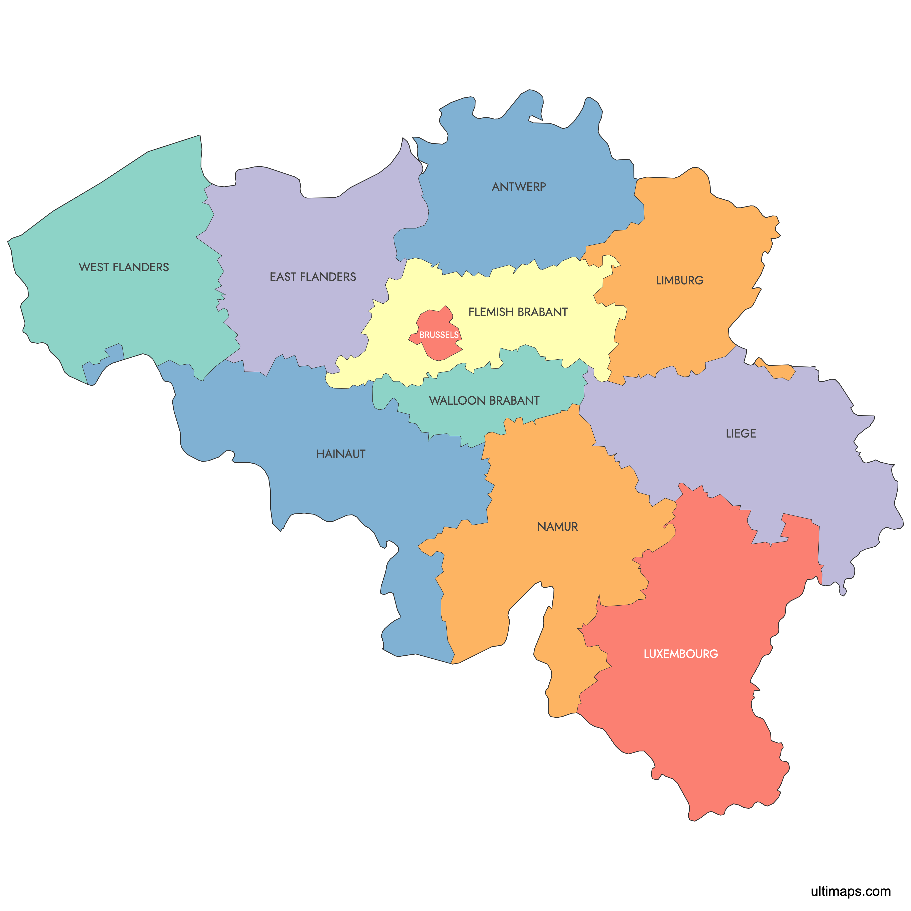
Map of Belgium Provinces
Belgium is divided into 10 provinces, split evenly between the Flemish Region and the Walloon Region, with the Brussels-Capital Region standing outside the provincial system. Use the interactive maps below to explore provincial boundaries, capitals, and neighboring countries. Download free reference maps or learn more about creating a custom map of Belgium to visualize your own data.
Interactive Map of Belgium Provinces
List of Provinces (11)
| # | Province |
|---|---|
| 1 | |
| 2 | |
| 3 | |
| 4 | |
| 5 | |
| 6 | |
| 7 | |
| 8 | |
| 9 | |
| 10 | |
| 11 |
About the Belgium Provinces Map
Belgium is divided into ten provinces, which serve as the main administrative divisions outside of the Brussels Capital Region. The provinces are grouped into the Flemish and Walloon regions, each reflecting cultural and linguistic distinctions in the country. Belgian provinces have defined boundaries that have been stable since the mid-1990s, following the administrative reforms that separated the Brussels Capital Region.
Key facts about the Belgium provinces map:
- Number of provinces: 10
- Provinces in Flanders: Antwerp, Limburg, East Flanders, Flemish Brabant, West Flanders
- Provinces in Wallonia: Walloon Brabant, Hainaut, Liège, Luxembourg, Namur
- The Brussels Capital Region is not part of any province
- Largest province by area: Luxembourg
- Most populous province: Antwerp
- Capital cities: Each province has its own capital, such as Antwerp for the Antwerp province and Namur for Namur
- Belgium shares borders with France, Germany, Luxembourg, and the Netherlands
Free Downloads
You can download free blank Map of Belgium Provinces and other maps in high resolution PNG, SVG and PDF formats from the blank maps section of the site: Download Blank Map of Belgium Provinces
Custom Map Features
This map supports labels.
This map is divided into 11 provinces.
Updates
Jun 16, 2025:
- Added map of Belgium Provinces
Frequently Asked Questions
Belgium has 10 provinces. Five belong to the Flemish Region (Antwerp, East Flanders, Flemish Brabant, Limburg, and West Flanders) and five to the Walloon Region (Hainaut, Liège, Luxembourg, Namur, and Walloon Brabant). The Brussels-Capital Region is a separate entity that performs provincial functions for its 19 municipalities but is not itself a province.
Luxembourg is the largest province by area at 4,459.01 km² (1,721.72 sq mi). Despite its size, it is also the least populated province, giving it a very low population density compared with the national average. It borders the country of Luxembourg to the south and France to the southwest.
Walloon Brabant is the smallest province at 1,091.29 km² (421.38 sq mi). Its capital is Wavre, and it is located just south of the Brussels-Capital Region. The province is also home to the Waterloo battlefield, site of the famous 1815 Napoleonic battle.
Antwerp is the most populous province with 1,920,024 inhabitants as of 1 January 2024. Its capital, the city of Antwerp, is Belgium's largest port and one of Europe's leading seaports, situated on the Scheldt River. Other notable cities in the province include Mechelen and Turnhout.
Bruges, the capital of West Flanders, is a UNESCO-listed medieval city known for its canals. Leuven in Flemish Brabant is home to KU Leuven, one of Europe's oldest universities. The Spa-Francorchamps Formula 1 circuit is located in the province of Liège, and the World War I battlefields and memorials at Ypres (Ieper) are in West Flanders.
Belgium shares borders with four countries: France to the southwest, the Netherlands to the north, Germany to the east, and Luxembourg to the southeast. The North Sea forms its northwestern coastline, with coastal towns such as Ostend and Knokke-Heist in the province of West Flanders.
You can use Ultimaps to create custom maps of Belgium. Color-code provinces manually or upload your data, place pins, customize the look, and export to PNG, PDF, or SVG. No sign-up required.