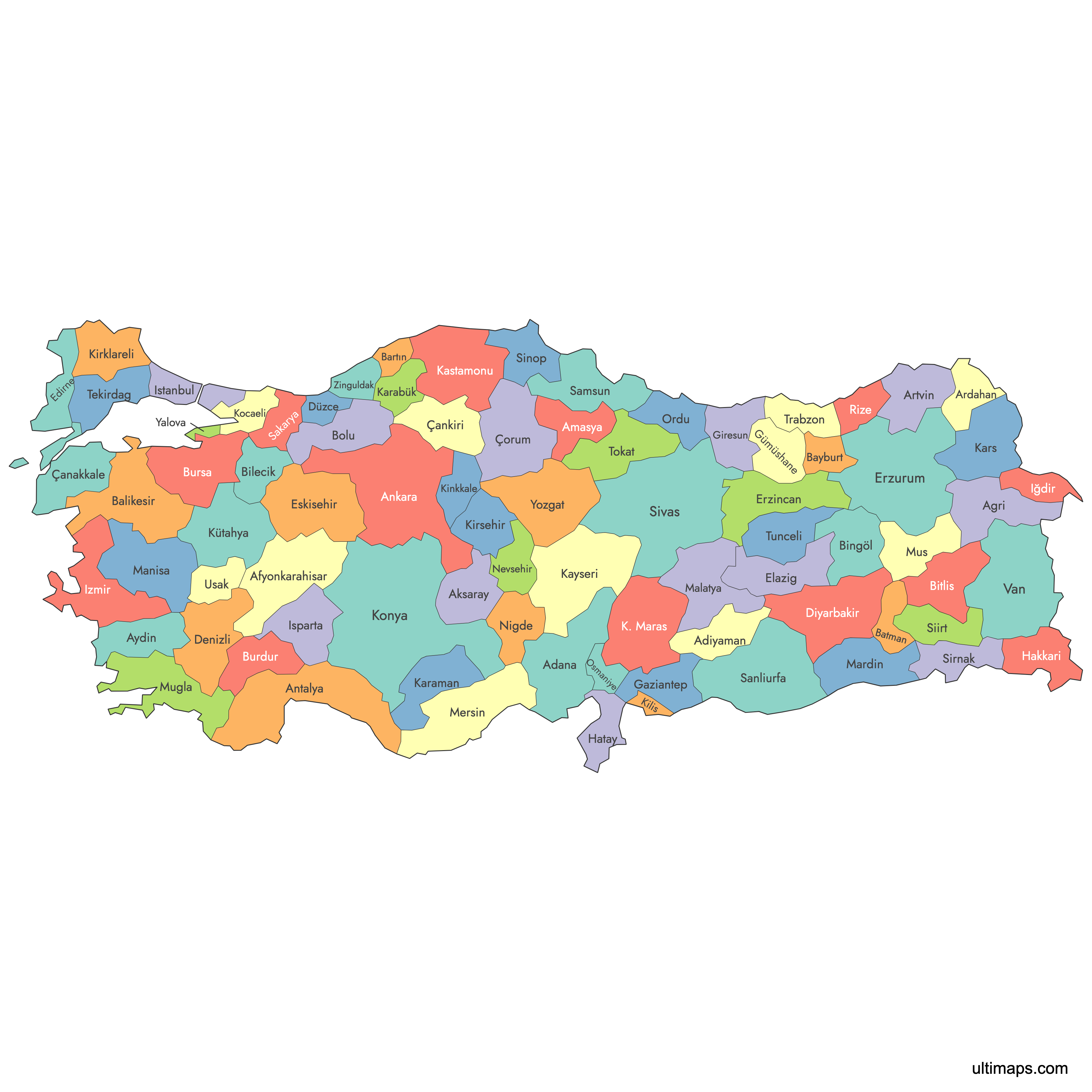
Map of Turkey
Turkey is divided into 81 provinces (iller), the country's top-level administrative units, each governed by a centrally appointed governor. Use the interactive maps below to explore provincial boundaries, major cities, and geographic features across both European and Asian Turkey. Download free reference maps or learn more about creating a custom map of Turkey to visualize your own data.
Interactive Map of Turkey
List of Regions (81)
| # | Region |
|---|---|
| 1 | |
| 2 | |
| 3 | |
| 4 | |
| 5 | |
| 6 | |
| 7 | |
| 8 | |
| 9 | |
| 10 | |
| 11 | |
| 12 | |
| 13 | |
| 14 | |
| 15 | |
| 16 | |
| 17 | |
| 18 | |
| 19 | |
| 20 | |
| 21 | |
| 22 | |
| 23 | |
| 24 | |
| 25 | |
| 26 | |
| 27 | |
| 28 | |
| 29 | |
| 30 | |
| 31 | |
| 32 | |
| 33 | |
| 34 | |
| 35 | |
| 36 | |
| 37 | |
| 38 | |
| 39 | |
| 40 | |
| 41 | |
| 42 | |
| 43 | |
| 44 | |
| 45 | |
| 46 | |
| 47 | |
| 48 | |
| 49 | |
| 50 | |
| 51 | |
| 52 | |
| 53 | |
| 54 | |
| 55 | |
| 56 | |
| 57 | |
| 58 | |
| 59 | |
| 60 | |
| 61 | |
| 62 | |
| 63 | |
| 64 | |
| 65 | |
| 66 | |
| 67 | |
| 68 | |
| 69 | |
| 70 | |
| 71 | |
| 72 | |
| 73 | |
| 74 | |
| 75 | |
| 76 | |
| 77 | |
| 78 | |
| 79 | |
| 80 | |
| 81 |
About Turkey's Provinces
- Number of Provinces: 81 provinces, further subdivided into 957 districts.
- Largest Province by Area: Konya — 38,260 km² (14,771 sq mi).
- Smallest Province by Area: Yalova — 850 km² (327 sq mi).
- Most Populous Province: İstanbul — 15,840,900 inhabitants (2021).
- Least Populous Province: Tunceli — 83,645 inhabitants (2021).
- Capital: Ankara, which is also a province.
- Bordering Countries: Greece and Bulgaria to the northwest, Georgia to the northeast, Armenia, Azerbaijan (Nakhchivan exclave), and Iran to the east, Iraq to the southeast, and Syria to the south.
- Surrounding Seas: Black Sea (north), Sea of Marmara (northwest), Aegean Sea (west), Mediterranean Sea (south).
- Time Zone: Turkey Time (TRT), UTC+3 year-round with no daylight saving time.
- Current Boundaries: The modern 81-province structure has been in place since the late 1990s, after the creation of provinces such as Düzce, Osmaniye, and Yalova.
Interesting Facts
- Each province is assigned a license plate code from 01 to 81. The first 67 codes follow alphabetical order, while codes 68 through 81 reflect the chronological order in which newer provinces were created.
- İstanbul Province straddles two continents, spanning both Europe and Asia across the Bosporus strait.
- Turkey's provinces descend from the Ottoman Empire's vilayet system and were reorganized under the Republic in the early 20th century.
- Konya Province, the largest by area, is home to the city of Konya, known worldwide as the resting place of the poet and mystic Mevlana (Rumi).
Free Downloads
You can download free blank Map of Turkey and other maps in high resolution PNG, SVG and PDF formats from the blank maps section of the site: Download Blank Map of Turkey
Custom Map Features
This map supports labels.
This map is divided into 81 regions.
Updates
Nov 21, 2024:
- Added map of Turkey Provinces
Frequently Asked Questions
Turkey has 81 provinces (iller), which are the country's top-level administrative divisions. These 81 provinces are further subdivided into 957 districts (ilçeler). Each province is headed by a governor (vali) appointed by the Ministry of the Interior.
Konya Province is the largest, covering 38,260 km² (14,771 sq mi). It is located in central Anatolia and is known as the home of Mevlana (Rumi). By contrast, the smallest province, Yalova, covers just 850 km² (327 sq mi).
Yalova Province is the smallest, with an area of only 850 km² (327 sq mi). It is located in northwestern Turkey along the Sea of Marmara. Yalova was one of the last provinces to be created, bringing the total to 81 in the late 1990s.
İstanbul Province is by far the most populous, with 15,840,900 inhabitants as of 2021. It is Turkey's economic and cultural center, straddling both Europe and Asia across the Bosporus. The least populous province is Tunceli, with 83,645 inhabitants (2021).
Göbekli Tepe, one of the world's oldest known temple complexes, is in Şanlıurfa Province. The ancient ruins of Troy and the Gallipoli battlefields are in Çanakkale Province. The medieval ruins of Ani, a former Armenian capital, are in Kars Province near the Armenian border.
Turkey shares land borders with eight countries: Greece and Bulgaria to the northwest, Georgia to the northeast, Armenia, Azerbaijan (Nakhchivan exclave), and Iran to the east, Iraq to the southeast, and Syria to the south. It is surrounded by the Black Sea to the north, the Aegean Sea to the west, the Mediterranean Sea to the south, and the Sea of Marmara internally.
You can use Ultimaps to create custom maps of Turkey. Color-code regions manually or upload your data, place pins, customize the look, and export to PNG, PDF, or SVG. No sign-up required.