Ultimaps Aug'24 Release: AI Updates, Interactive Maps Improvements
In our August release, we have made significant enhancements to our AI features and the interactive map editing experience. Additionally, we have introduced the option to enable labels on maps.
Updates to AI-Generated Maps
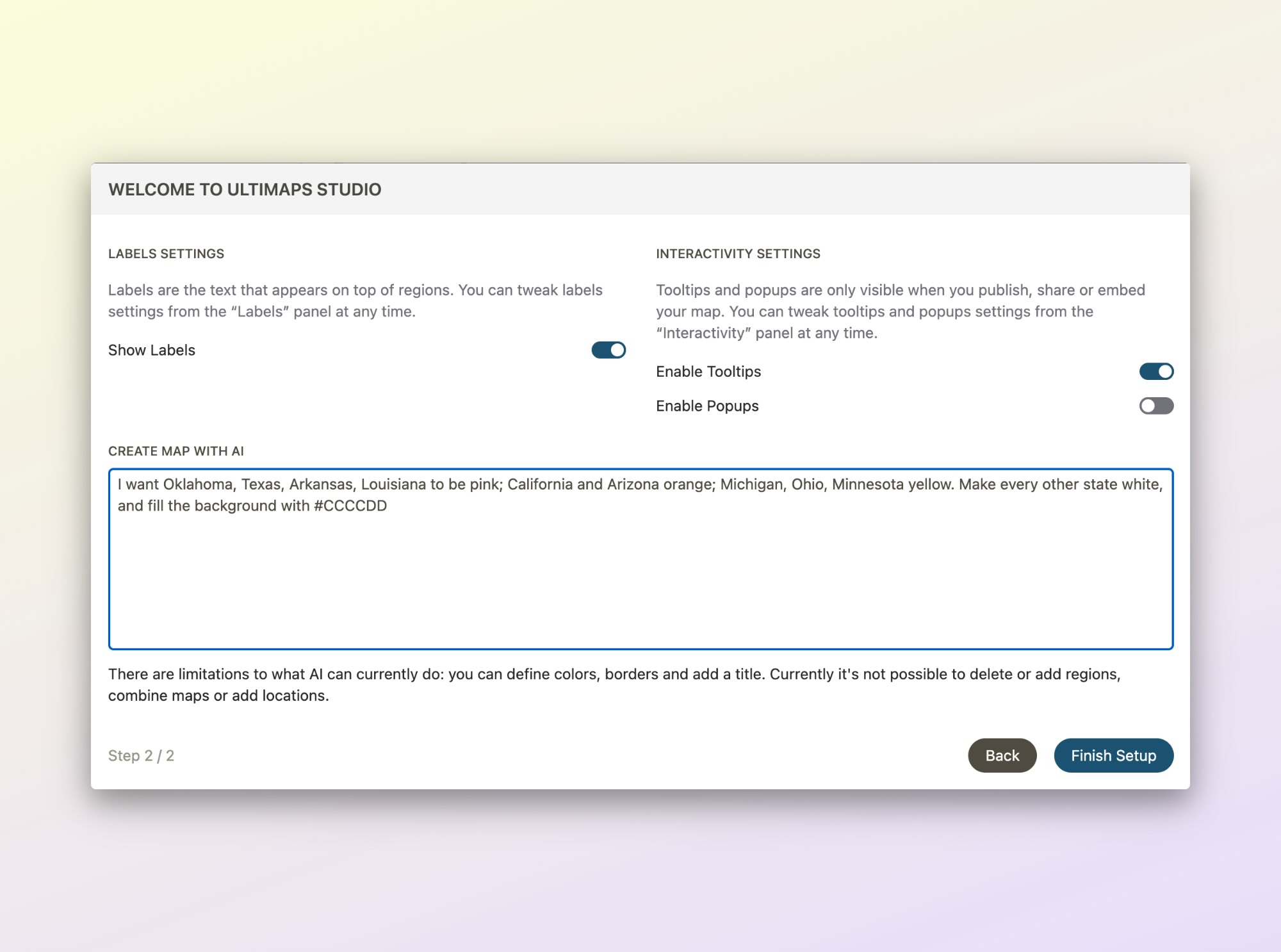
With this update, Illustration maps can now be generated using AI. Often, our users create these maps without importing spreadsheet data, preferring to color the maps manually. We have streamlined the process, allowing users to generate such maps using natural language instructions. For example, in order to create and color a map of the United States you can type:
I want Oklahoma, Texas, Arkansas, Louisiana to be pink; California and Arizona orange; Michigan, Ohio, Minnesota yellow. Make every other state white, and fill the background with #CCCCDD.
We have also improved the algorithm to accurately interpret hex color codes and support defining the colors of the map's background and borders. Additionally, users can specify a map title, which will be automatically included in the final design.
Labels on Maps
This highly requested feature now allows you to enable labels on your maps and customize their appearance. You can optionally enable labels to display only for regions with assigned colors. Furthermore, a dedicated panel has been added to the editor to manage label settings.

This feature is currently available for selected maps, and will be rolled out to other maps in subsequent updates. Supported maps include: the United States, the United States with Territories, all states of the United States, Germany, Qatar and United Arab Emirates.
Interactive Maps Improvements
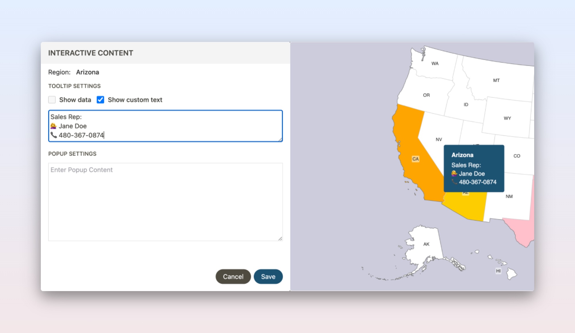
We have enhanced the editing experience for interactive maps. Users can now customize the content of tooltips or popups for specific regions, providing an additional layer of personalization to their interactive map designs. We also added support for the tooltips and popups to the Illustration maps.
New Maps
We added a whole set of US states divided into counties to the collection:
- Map of Alabama
- Map of Arizona
- Map of Arkansas
- Map of California
- Map of Colorado
- Map of Connecticut
- Map of Delaware
- Map of Florida
- Map of Georgia
- Map of Hawaii
- Map of Idaho
- Map of Illinois
- Map of Indiana
- Map of Iowa
- Map of Kansas
- Map of Kentucky
- Map of Louisiana
- Map of Maine
- Map of Maryland
- Map of Massachusetts
- Map of Michigan
- Map of Minnesota
- Map of Mississippi
- Map of Missouri
- Map of Montana
- Map of Nebraska
- Map of Nevada
- Map of New Hampshire
- Map of New Jersey
- Map of New Mexico
- Map of New York
- Map of North Carolina
- Map of North Dakota
- Map of Ohio
- Map of Oklahoma
- Map of Oregon
- Map of Pennsylvania
- Map of Rhode Island
- Map of South Carolina
- Map of South Dakota
- Map of Tennessee
- Map of Texas
- Map of Utah
- Map of Vermont
- Map of Virginia
- Map of Washington
- Map of West Virginia
- Map of Wisconsin
- Map of Wyoming
Thank you for reading, and happy color-coding, everyone!
Published Aug 31, 2024