Liberia Map with Counties
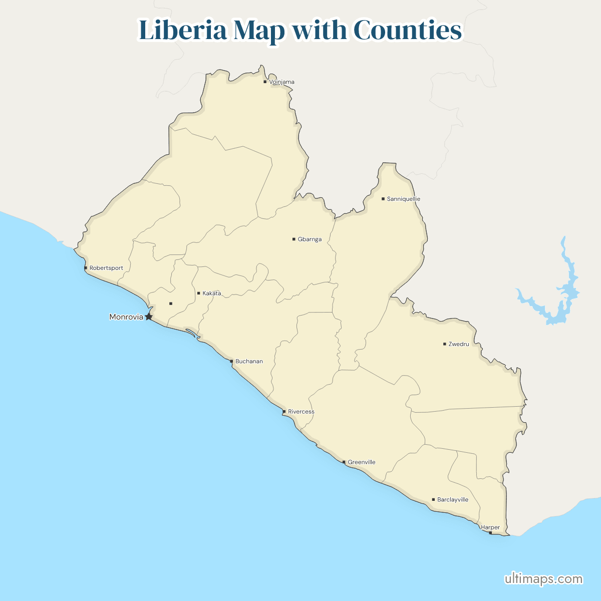
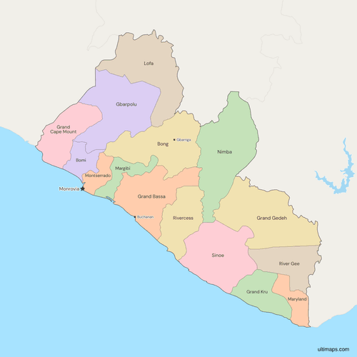
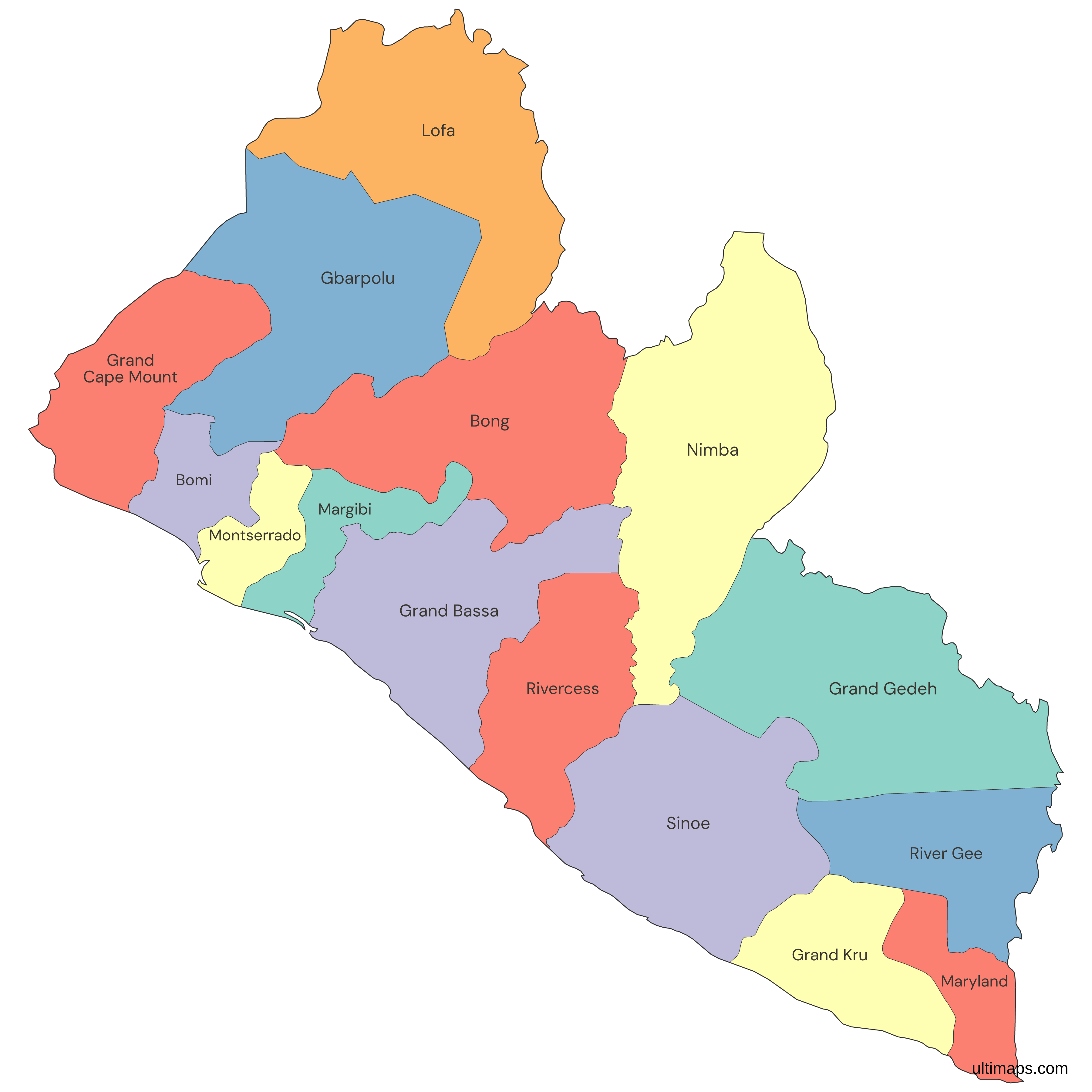
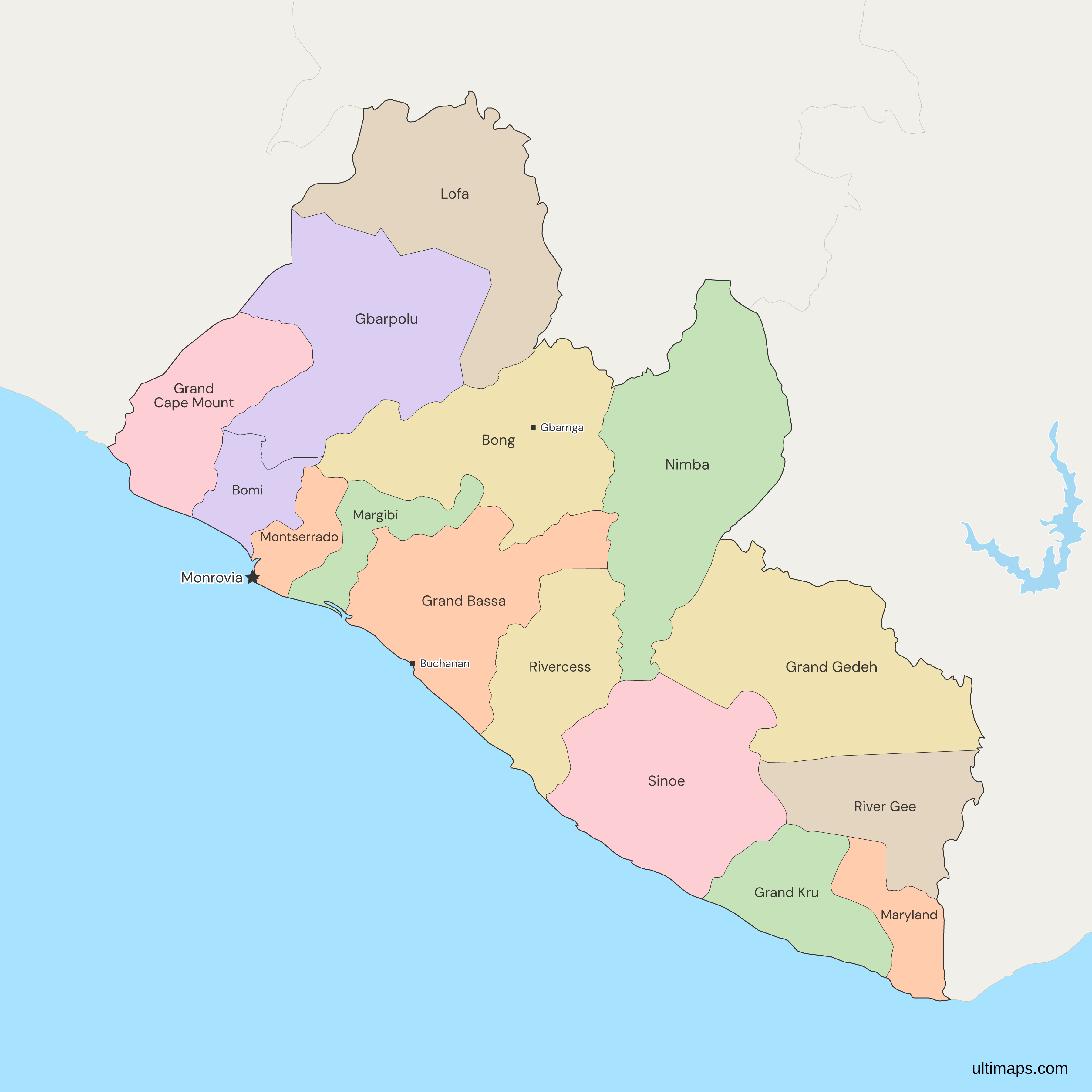
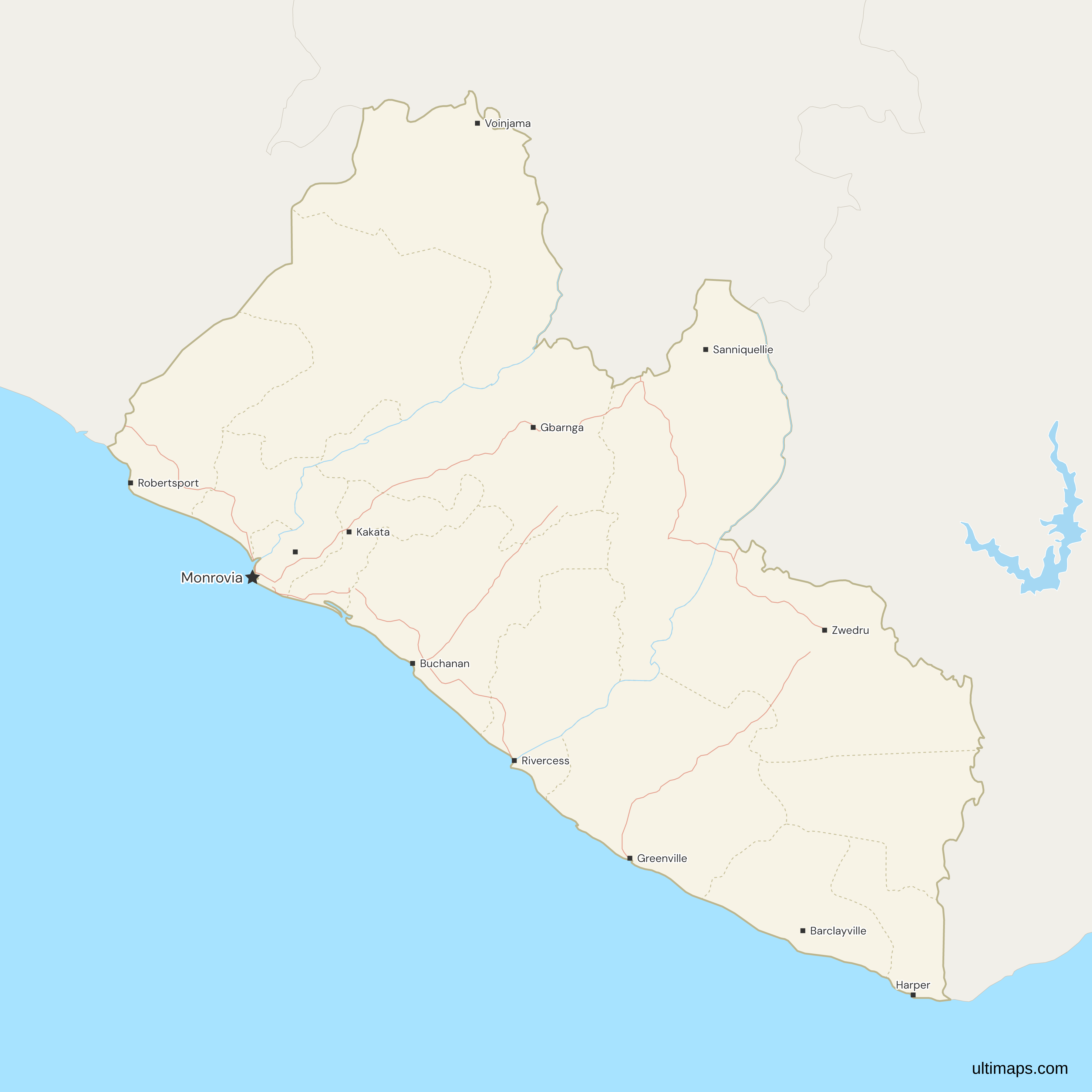
This map of Liberia shows all 15 counties, the set in place since 2001. River Gee was cut from Grand Gedeh in 2000, and Gbarpolu from Lofa in 2001. Nimba is the largest, with a land area of 11,551 km² (LISGIS, 2022), and Montserrado the smallest at 1,909 km². Montserrado still has the most residents, 1,920,965 in the 2022 census (LISGIS), about 37% of the national total. Monrovia, the national capital, lies in Montserrado County, whose county seat is Bensonville. No 16th county had been enacted as of November 2026.
Open the map in the free Ultimaps editor to make your own custom map of Liberia. You can color the counties by your data, add pins and labels, and share or embed the finished map.
Interactive Liberia Map with Counties
List of Counties (15)
| # | County | Capital | Population (2022) | Land area (km², 2022) |
|---|---|---|---|---|
| 1 | Bomi | Tubmanburg | 133,705 | 1942 |
| 2 | Bong | Gbarnga | 467,561 | 8,772 |
| 3 | Gbarpolu | Bopolu | 95,995 | 9,689 |
| 4 | Grand Bassa | Buchanan | 293,689 | 7,936 |
| 5 | Grand Cape Mount | Robertsport | 178,867 | 5,162 |
| 6 | Grand Gedeh | Zwedru | 216,692 | 10,484 |
| 7 | Grand Kru | Barclayville | 109,342 | 3,895 |
| 8 | Lofa | Voinjama | 367,376 | 9,982 |
| 9 | Margibi | Kakata | 304,946 | 2,616 |
| 10 | Maryland | Harper | 172,587 | 2,297 |
| 11 | Montserrado | Bensonville | 1,920,965 | 1909 |
| 12 | Nimba | Sanniquellie | 621,841 | 11,551 |
| 13 | River Gee | Fish Town | 124,653 | 5,113 |
| 14 | Rivercess | Cestos City | 90,819 | 5,594 |
| 15 | Sinoe | Greenville | 151,149 | 10,137 |
Data sources:
- Capital: Statoids, Counties of Liberia; LISGIS, 2022 census thematic report on migration and urbanization. License: facts compiled by Ultimaps, CC BY 4.0.
- Population: LISGIS, 2022 Population and Housing Census, Final Results, Table A3. License: CC BY 4.0.
- Land area: LISGIS, 2022 Census Thematic Report on Population Size, Distribution and Structure, Table 2.5 (square miles converted to km² by Ultimaps). License: CC BY 4.0.
Liberia Counties: Key Facts
- Number of counties: 15, all of the same type, with no separate capital district. Liberia's 1986 constitution does not name the counties, and it gives the Legislature the power to create counties and readjust their boundaries.
- Capital: Monrovia, the national capital, in Montserrado County. The county seat of Montserrado is Bensonville.
- Largest and smallest by land area: Nimba at 11,551 km² and Montserrado at 1,909 km² (LISGIS, 2022). Grand Gedeh (10,484 km²) and Sinoe (10,137 km²) follow Nimba, and Bomi (1,942 km²) is the second smallest.
- Most and least populous: Montserrado with 1,920,965 residents and Rivercess with 90,819 (LISGIS, 2022 census). The 15 counties total 5,250,187.
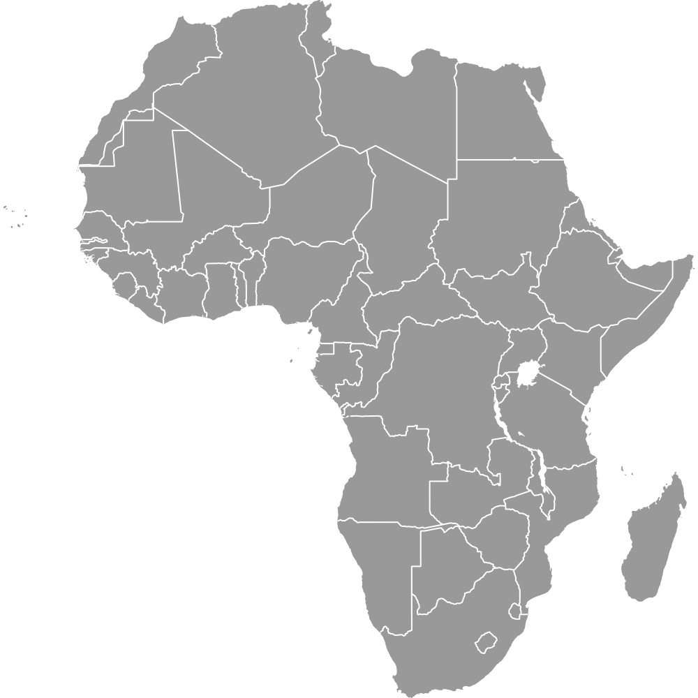
- Borders: on the west African coast (Africa map), Liberia borders Sierra Leone, Guinea and Côte d'Ivoire. Grand Cape Mount, Gbarpolu and Lofa touch Sierra Leone. Lofa, Nimba and Bong touch Guinea. Nimba, Grand Gedeh, River Gee and Maryland touch Côte d'Ivoire.
- Coast: 9 counties reach the Atlantic: Grand Cape Mount, Bomi, Montserrado, Margibi, Grand Bassa, Rivercess, Sinoe, Grand Kru and Maryland.
- Inland counties: 6 have no coast: Gbarpolu, Lofa, Bong, Nimba, Grand Gedeh and River Gee.
- Last change: River Gee was split from Grand Gedeh (Senate approval of 7 March 2000) and Gbarpolu from Lofa (Senate approval of 14 September 2000, in force 2001). The count has been 15 since.
- Codes: ISO 3166-2 codes run LR-BM, LR-BG, LR-CM and so on, such as LR-MO for Montserrado and LR-NI for Nimba. LR-GP and LR-RG were added in 2007 for the two newest counties.
- Pending: a 2018 Senate bill to create a Bong Range County from Lower Bong was sent to committee and has not been enacted, and the Sinoe and Grand Gedeh line came under House inquiry in February 2026.
Interesting Facts
- Montserrado, the smallest county by area, has about 21 times the residents of Rivercess, the least populous.
- The county lines are largely undemarcated, so the map's inner borders are approximate.
- The map draws no lake inside Liberia, so Lake Piso and the coastal lagoons do not appear.
Free Downloads
Free for personal and commercial use with a credit to Ultimaps. See the license terms for details.
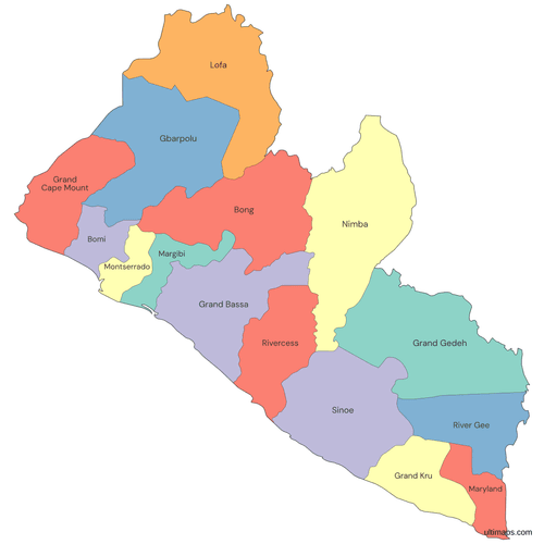 Colored Liberia Map with Countiespng460 KB
 Political Map of Liberia with Countiespng495 KB
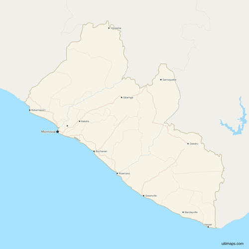 Map of Liberia with Cities and Roadspng534 KB
Need it without colors? The blank version of this map comes as a print-ready PDF (A4 and US Letter), a PNG and an editable SVG.
Custom Map Features
This map supports labels.
This map supports surrounding areas, roads, rivers and cities. New
This map is divided into 15 counties.
Updates
Nov 5, 2026:
- Added map of Liberia counties
Frequently Asked Questions
Liberia has 15 counties, and it has had 15 since 2001. River Gee was split from Grand Gedeh in 2000, after Senate approval on 7 March 2000. Gbarpolu was split from Lofa after Senate approval on 14 September 2000 and took effect in 2001, which brought the 13 older counties to 15. The 1986 constitution leaves the creation of counties and the adjustment of their boundaries to the Legislature. No 16th county had been enacted as of November 2026. A 2018 bill for a Bong Range County was sent to a Senate committee and has not been enacted. The same outline also appears on the world map.
The capital of Liberia is Monrovia, which lies in Montserrado County. Monrovia is not the seat of Montserrado, whose county seat is Bensonville. The two places are separate towns in the same county, and the map marks Monrovia with the national-capital star. Other county seats include Gbarnga in Bong, Zwedru in Grand Gedeh and Harper in Maryland. Montserrado is also the smallest county by land area, at 1,909 km² (LISGIS, 2022), so the national capital sits in the most compact county in the country.
Liberia's largest county is Nimba, one of only three above 10,000 km² of land area (LISGIS, 2022). Nimba covers 11,551 km², ahead of Grand Gedeh at 10,484 km² and Sinoe at 10,137 km². It lies in the northeast, borders both Guinea and Côte d'Ivoire, and has no coast. Montserrado, the smallest, covers about one sixth of Nimba's area. The county lines are largely undemarcated, so areas measured from a map differ from the official figures, and this page uses the LISGIS census figures for every ranking.
Montserrado covers just 1,909 km² of land (LISGIS, 2022), which makes it Liberia's smallest county. Bomi comes next at 1,942 km², only 33 km² larger. Maryland ranks third at 2,297 km² and Margibi fourth at 2,616 km², and no other county falls under 3,000 km². Maryland is the only one of these four on an international border, with Côte d'Ivoire. Nimba, the largest county, is about six times the size of Montserrado. The ranking uses the LISGIS land area, not the area measured from the map.
In the census taken on the night of 11 November 2022, Montserrado County counted 1,920,965 residents (LISGIS), the most of any Liberian county. Final results replaced the provisional figures published in early 2023. Nimba follows with 621,841 and Bong with 467,561, so the capital county outnumbers the next two combined. Rivercess has the fewest residents at 90,819, followed by Gbarpolu at 95,995. The 15 counties total 5,250,187 residents, and the five largest hold about 70% of them. The ten smaller counties share the remaining 30%.
Liberia is divided into 15 counties rather than states, each run by a superintendent whom the president appoints with the consent of the Senate, which makes the superintendent the nearest thing to a state governor. Under the 1986 Constitution, the Legislature alone can create counties or readjust their boundaries. Counties are sometimes grouped into regions for statistics, but a region is not an administrative unit, so those groupings never appear as a layer on the map. The counties are the only first-level layer you can color here.
Liberia's six inland counties are Gbarpolu, Lofa, Bong, Nimba, Grand Gedeh and River Gee. Guinea is bordered only by inland counties: Lofa, Nimba and Bong. Côte d'Ivoire is reached by Nimba, Grand Gedeh and River Gee, and also by coastal Maryland in the far southeast. The other nine counties reach the Atlantic, from Grand Cape Mount near the Sierra Leone border to Maryland on the Côte d'Ivoire border, with Bomi, Montserrado, Margibi, Grand Bassa, Rivercess, Sinoe and Grand Kru between them.
The Ultimaps editor is free, needs no account, and opens this map of Liberia as a starting point. To color the 15 counties from a table, enter one value per county, using names or codes such as LR-MO. Rivercess also matches River Cess. You can also color by hand, add pins for towns such as Buchanan or Harper, and share or embed the result. A free export is a standard PNG with a small Ultimaps credit, and high-resolution PNG, SVG and PDF exports are part of the Pro plan.